Wednesday, January 26, 2011

Snow Line Pushing Into Eastern NJ


For all the patient souls waiting for the snow, the line is almost to the coastline. There still will be some sleet and freezing rain in the eastern counties, but the line is pushing towards the coast. The freezing rain and sleet has made for extremely dangerous and treacherous travel. Now with the wet snow and colder air moving down to the surface, the ice and water will solidify well.

The snowfall rates of one to three inches will be very common. Some isolated four inch per hour pockets are likely. Thunderstorms have been reported tonight with rare thundersnow and thundersleet. What was even more interesting is that there was hail reported in eastern Ocean and Monmouth Counties from a strong thunderstorm… that even appeared to have some upper level rotation over water.

Snow Line Continues Progress Eastward

Rapid Changeover Next Two Hours...Thunderstorms...Strong Winds


DO NOT DRIVE THIS EVENING AND TONIGHT UNLESS ABSOLUTELY NECESSARY.

The snow line will rapidly move to the coastline. In addition, the thunderstorms will pull down colder air helping to change any potential rain to sleet and quickly to snow. The thunderstorms could contain quite a bit of unusual lightning for this time of the year, let alone with snow. Snowfall rates of one to four inches per hour likely! Roads will become impassible.

Strong winds being reported will only get stronger as the storm intensifies. While there are no blizzard warnings, I believe we may be very close or hit the criteria at least somewhere.

The temperatures are now starting to drop and the expected flash freeze is now in progress of developing.

Blizzard Tonight?


I am watching the wind speeds at this hour as they continue to get stronger. This wind I think will get even stronger this evening as rapid deepening continues to occur as the low moves up from the Carolinas and gets energized by a strong piece of energy moving from the southwest. Winds are already sustained 15 to 20 MPH with gusts to 30 MPH. If these winds increase further, they could approach limits that would take down a weak tree and some branches. What I am more concerned about with the wind is the potential for blizzard conditions this evening as the strongest winds could coincide with the heavy snowfall rates.

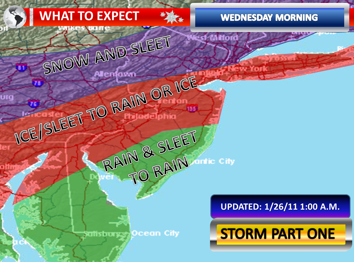
The snow this morning as transitioned to a light mix of precipitation. If the precipitation is light, it is in the form of drizzle. This is the lull before a quick intensification of the system this evening into early Thursday Morning. Temperatures are just around or above freezing right now. Once the precipitation becomes heavy again, we lose daylight, and we see the precipitation change to snow …flash freezing will occur.

The water on the trees, surfaces, and wires will turn to ice. This will add some weight to the trees and wires. Then as we see wet snow begin to fall, this will stick very easily to the ice. The worst still looks to be from 7:00 p.m. to 2:00 a.m. The second piece of energy looks quite strong and potent at this hour. One must wonder what awaits with this joins forces.

The snowfall map from this morning remains unchanged. 10 to 16 inches total with less in the far Northwest and the far Southeast looks good at this time. This includes the snow from this morning which averaged 1.5 to 5 inches. Thunderstorms are possible with sleet and snow.

Significant Upgrade in My Snowfall Forecast


I am still expecting the sleet and perhaps some rain or freezing rain. But as soon as it is time for the evening commute...snow will takeover. The new NAM blasts the Garden State with very heavy snow and near-blizzard conditions.

I am going to increase my totals. It appears even Cape May could get several inches after holding out the longest with mixing.

This snow map also includes the messy one to four inches that occured this morning.

Unexpected Snow Causes Morning Commute Nightmare


Last night, Kathy Orr from CBS 3 and I were talking about the possibilities of what may happen with this winter storm. She was concerned that this storm would not behave as the models projected and she could not be more correct. Heavy snow developed this morning and has left an accumulation everywhere, even in Southern New Jersey. A wintry mix is lifting up slowly through Southeastern New Jersey and is trying to push up to Philadelphia. The snow is also a wet snow which is causing accumulations on trees and power lines. At the very moment, the precipitation could shut off before that snow line makes as it that far north.

Roadways are totally snow covered in many spots around Central and Southern New Jersey. Along the mixing line, there is some evidence of icing and sleet accretion. The morning commute is a mess as this is more than a nuisance event. This is what we would call an over performing system because of the much more intense precipitation areas than what the models and forecasts called for.

Areas that remain snow could see several inches this morning before a lull when part two starts. Some areas that may eventually switch to a wintry mix still will see several inches. Areas that see a wintry mix still may see quite a bit of sleet and freezing rain. Rain and some sleet will fall in Southeastern New Jersey and along the coastline.

Round two will be a subject for later this morning.

Morning Light Mix, Drizzle/Light Rain Before Part 2


Temperatures this evening fell back into the upper twenties and lower thirties across the region. As precipitation approaches, some sleet will develop...even with some brief wet snow. The sleet could be mixed with rain. The rain may freeze on surfaces causing a very light, but hazardous coating of ice. Temperatures will rise as the column moistens, but it will only be in Southeastern New Jersey where they will rise above freezing before the rain begins. Eventually, the wintry mix will change to light rain or drizzle somewhere between 9:00 a.m. and Noon.

The morning commute will be sloppy. However, this is a nuisance compared to what will likely transpire for the evening commute into the night. The liquid to work with will generally be under 0.25” of an inch. Snow and sleet without a change to any rain would occur further north and west.