Showing posts with label Wintry Mix. Show all posts

Sunday, February 20, 2011

2/20/2011 Extended Forecast: Wintry Mix Overnight, Again Monday Night

8:35 p.m. UPDATE: The National Weather Service is now expanding the advisory to include Monmouth and Mercer Counties.


Precipitation arrives around or before Midnight.

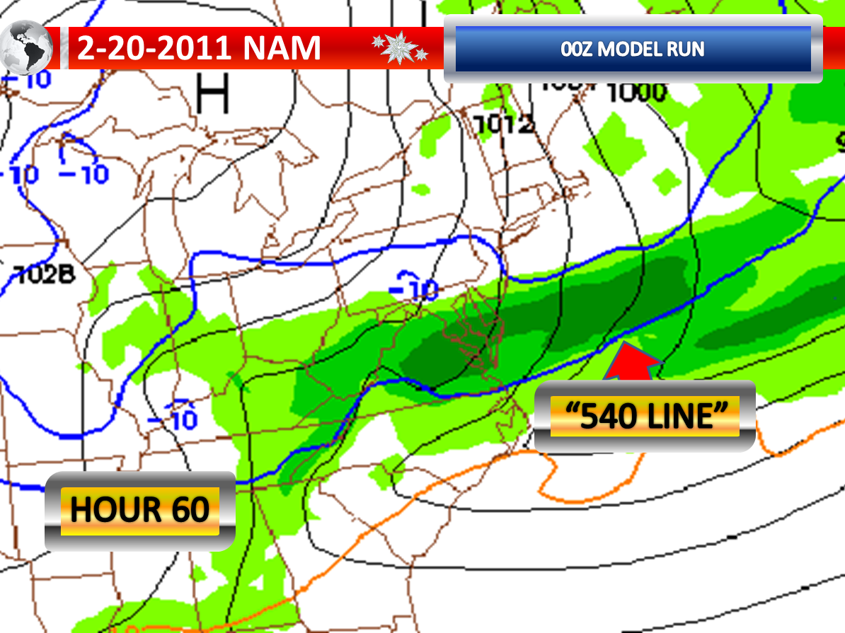
A winter weather advisory has been issued for Sussex, Warren, Morris, Hunterdon, Middlesex, Bergen, Union, Essex, Hudson, and Passaic Counties. These areas will likely see a burst of heavy precipitation overnight with a warm front and it will also be cold enough for several hours of wet snow and sleet. Two to four inches of accumulation is quite possible in these areas, with perhaps localized higher amounts. There could even be some rain or freezing rain mixed in at times in these areas. The latest high resolution models are showing that it continues to snow and sleet in Northern New Jersey even into the morning commute. The “540 Line” on the 18z GFS and 18z NAM continues not to move north of Central New Jersey which is a change from twenty-four hours ago.

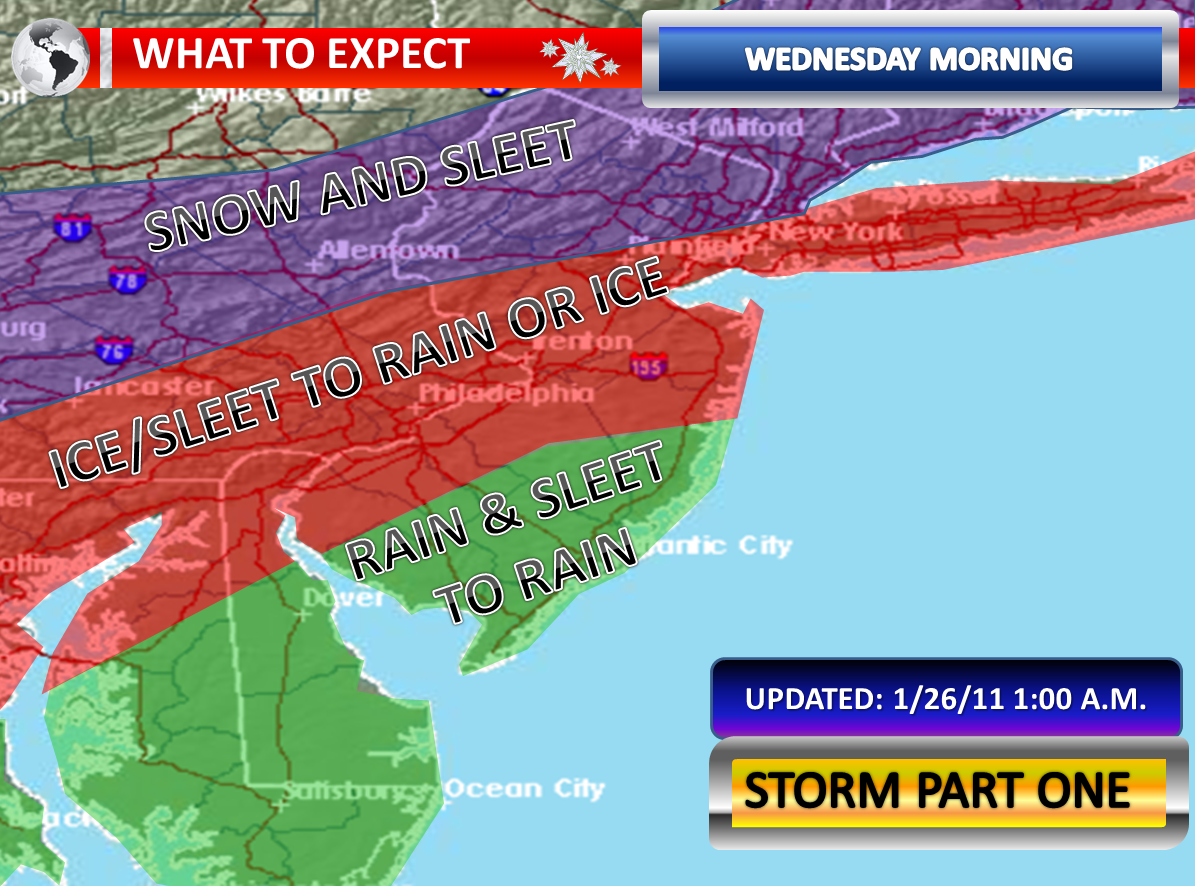
Meanwhile, in areas between Interstate 195 and the Atlantic City Expressway, there will initially be sleet and possible wet snow. A gradual rise in temperatures in this area should allow the snow and sleet to switch over to rain. The models are not painting much measurable precipitation in this area and with a faster transition expected here, I would suspect the accumulations will be limited to a coating to an inch at most. Should the precipitation be more pronounced in this area or should temperatures not respond to the warm air advection, then we could have some problems this far south as well and this will have to be handled with great caution.

From the Atlantic City Expressway and points south, the model guidance does not show much measurable precipitation at all. The lack of heavy intensity and warmer air temperatures suggests a drizzle and fog situation here with gradually rising temperatures in this area. The area will be entering the warm sector into Monday Morning and some very gusty winds may develop in the area, eventually dissipating the fog. The wind gusts could be strong for a time in this area. Should a shower form before the morning commute, it could contain some sleet pellets.

A lull is likely by midday. Temperatures will rise and will begin to drop as the evening approaches. There could be quite a contrast from north to south.

Round two, with an area of low pressure moving to our south, will be an even colder event. The change here is that the guidance has shifted the low further to the north and so has this expected aggressive band of heavier precipitation. It appears as though temperatures will rapidly drop as precipitation breaks out with this second round late Monday Night into Tuesday Morning. This means rain will likely transition to snow and sleet. There could be precipitation heavy enough for accumulations in the zone from Interstate 195 and points south. The precipitation may be heaviest in Cape May County, but this is where it will be warmest. Overall, this band is going to setup somewhere and could be quite intense where it does, even possibly containing some thunderstorms. There could be a sharp gradient in snow and sleet with this band, especially if it is a narrow intense band of snow as some of our higher resolution models show. Transitioning precipitation types, mixing, and warmer ground temperatures make the accumulation projections quite difficult with this second system. Some places could end up with 3 to 6 inches of snow, but where is the big question.

Wednesday through Friday will be impacted by any potential snow on the ground. A warm front will approach on Thursday with a strong cold front and low pressure area on Friday. Friday could end up being quite wet according to the long term guidance. The clouds and rain look to limit the temperatures in the extended, which if it was not raining would have a shot at reaching 60 degrees. The cold front timing is also faster and therefore Saturday won’t be as warm as I initially was hoping for.

Wintry Mix Threat Tonight for Some, Snow & Sleet Threat Late Monday into Tuesday for Some


Trouble could be brewing.

System number one is only about eighteen hours away. The computer model guidance this morning is much colder and shows more available liquid with the 12z Guidance for Northern and Central New Jersey. The “540 Line” on both models never really lifts through Central New Jersey on both the GFS and NAM models during the heaviest precipitation. Temperatures this morning are running several degrees colder than the guidance indicated. The column also seems to be colder when peaking at the atmospheric profiles.

It would appear as though some areas may see the precipitation start as wet snow, with a mixture of sleet where the precipitation is heavy enough. There still is expected to be a transition to rain in Central New Jersey, but this could be delayed until the steadier precipitation turns lighter and more sporadic. Meanwhile, it still appears that south of the Atlantic City Expressway, the precipitation will be light and the likely conditions would be fog and drizzle. But, if heavier showers should occur here, they may contain some sleet pellets initially. It could be a very interesting temperatures situation on Monday Morning with a huge difference from north to south.

The models continue to show a lull during Monday, around midday. A second low pressure area will pass to our south on Monday Night into Tuesday. However, the 12z Guidance has trended further to the north. As you can see from the previous post, the NAM model has the heavy axis of precipitation in Delaware last night. The latest 12z NAM model shows the heart of this site’s forecast area seeing that band of heavier precipitation. Even the GFS from 12z has shifted further to the north, showing the heavier band including more of Southern New Jersey. The models also seem to be a bit colder with this storm as well, indicating a faster transition to sleet and wet snow.

With the transitioning precipitation and the bouncing back and forth on the models, it is very hard to make a snow and sleet graphic prediction. I think someone could end up with as much as four to six inches of snow and sleet when this is all said and done…but where is the question that really doesn’t have an answer at this late hour.

Burst of Snow & Sleet Monday Night into Tuesday or Nothing?


The Monday Night into Tuesday possible snow and sleet event is now about 54 to 60 hours away. There is a lot to iron out between now and Monday Night. The 00z guidance is now in.

The GFS from 00z suggests that the area of low pressure passing to our south will be closer to our region. This track would be somewhat warmer as a result, with the “540 Line” pushing through our region as the precipitation begins to fall. This would indicate a transition from rain to sleet and snow in areas that receive precipitation. The GFS shows a fairly decent burst of precipitation in Southern New Jersey as it continues to get colder. It looks like the model is showing some convective banding, so even some thunderstorms would be possible. Notice the sharp cutoff though. New Brunswick is not getting anything measurable while Hammonton, Atlantic City, and Cape May are getting heavy precipitation. But here is the thing if this solution were correct. Is Cape May really going to see it change to all wet snow and sleet with the “540 Line” in the location it is? This could be a situation where the heaviest burst doesn’t necessarily coincide with temperatures supportive for snow. It will be a close call.

Meanwhile, the NAM shows the “540 Line” almost down into the Delmarva as the precipitation begins. But even here, some rain or mix initially would occur where it precipitates. However, it shows such a strong push of colder air, that the storm is actually suppressed by the heavier and denser air and practically misses most of New Jersey with the exception of Cape May. It shows intense banding though in Southern Delaware. So while it is cold for accumulations on the NAM, there is literally precipitation that will be non-existent if this solution were correct.

At this point, I continue to believe Southern New Jersey has the best chance at observing accumulations, if any at all. Will the surface be too warm? Will it be precipitating at all? Will the precipitation be transitioning to all frozen? These are three questions which do not have definitive answers as of early Sunday Morning.

Saturday, February 5, 2011

Colder Start To Winter Weather Event?


The clouds have had a great difficulty building into our region so far and now just hours away from the start of precipitation, we still have some breaks in the clouds being reported. The clear conditions have allowed temperatures to drop very well north of the Atlantic City Expressway with lower and mid-twenties for current temperatures. This suggests a colder start to the temperatures when the precipitation arrives. This probably means the column of air will be colder higher up, allowing for a more prolonged period of sleet mixing with freezing rain than just freezing rain. It still is not cold enough all the way up for much more than an hour of snow. We were expecting to start off from 28 or 29 degrees by dawn. Now we are starting off at 20 to 23 degrees in some cases. A southerly wind will cause the temperatures to rise ever so often once it kicks in. But the recovery may be slower than expected. It can be a substantial rise with a nice, persistent southerly flow...but the winds don't look to strong...hmmmm....

On the other side of the aisle is that the later start time means more precipitation will be falling as daylight comes upon us and usually any frozen precipitation has more difficulty sticking and temperatures respond faster when there is some solar radiation. This idea could have some merit to it and counter the fact that we have seen a significant drop in temperature tonight.

As of 11:54 p.m.:

21 in Wrightstown
23 in Mount Holly
23 in Southampton
20 in Lakehurst
28 in Belmar
33 in Atlantic City
33 in Millville
15 in Somerville
13 in Morristown
24 in Trenton
28 in Newark

Friday, February 4, 2011

2/4/2011 Extended Forecast: Wintry Mix, 2 More Storms


Another wintry mess is about to strike. Sussex, Warren, Morris, Bergen, Passaic, Union, Essex, Hudson, Mercer, Monmouth, Middlesex, Hunterdon, Somerset, Northwestern Burlington, Camden, Gloucester, and Salem Counties are under a winter weather advisory on Saturday. South of Interstate 195, the advisory expires by midday. Up north, it expires late Saturday Night. The snow amounts will be minimal in comparison with other storms. However, the freezing rain criterion is a trace for an advisory and these amounts will definitely be realized across the advisory area. A trace of freezing rain can cause widespread accidents and bring things to a halt. In fact, these minor events can be more hazardous as many usually do not stay home…especially with ice as many just believe it is liquid rain falling.

Initially, there could be a brief period of wet snow. This period of snow is going to be limited if the latest model guidance is correct. I think there will be a quick transition to sleet and rain. In the advisory areas, temperatures on Saturday Morning will hover around the freezing mark or remain slightly below that which poses a risk for the rain freezing on services. The below freezing temperatures could linger for the entire event on Saturday in Northwest New Jersey. The high resolution models indicate temperatures rising to about 33 or 34 degrees in the interior of Central and Southern New Jersey, so this will be a close call. At this point, I will put out an ice map. There could be a lull around mid-afternoon as an upper-level low pressure area that delivered a rare winter storm to southern Texas comes in.

The models are slower with the intensification of a coastal storm as I look at the 18z suite. This means that only snow showers will occur as the storm pulls away and we contend with an upper level low of energy that may yet combine to form a true coastal storm by that time. Northern New Jersey still has the potential to pick up an inch or two of snow as the system pulls away. This area of snow could perhaps extend into portions of Central New Jersey. The GFS also shows that initially the low would be inland, so this would in fact help with a warm push of air into New Jersey unlike previous solutions which had the low offshore when passing out latitude. At this present time, I will put out a map indicating where the best potential lies for a light snow accumulation.

Please look for updates on Saturday as this system affects New Jersey. Refresh your browser frequently tomorrow.

Sunday and Monday will be tranquil. Tuesday is appearing to be more active on the latest computer model guidance. A front will move through our region with an area of low pressure developing on it. This could cause a six hour period of steady, accumulating snow. The timing of the frontal energy would be critical as if the front lags behind, we initially would have more rain than snow. The 18z suite of models shows the cold air catching up to us before the balk of the precipitation. This frontal passage will have to be monitored for interaction with moisture coming up from Florida to see if it would generate a coastal low or intensify a low forming on the front further. The frontal passage could usher in some fairly good wind gusts.

On Thursday, the computer models today backed off on a solution that indicated the potential for a significant winter storm with primarily snow. This is typical of long range models and my guess would be that overtime it may shift this storm back to a coastal solution or even bring it inland further. The Tuesday event must pass us by before we can get specific details on this system. Climatology wise, there is definitely reason to believe something could be in the pipeline. The 18z GFS by the way shows the area completely dry for Thursday and Friday of next week. This storm is out of the five day forecast range, but there have been many questions about it considering the concern raised yesterday by those that focus on the long range when some of the guidance had a serious snowfall on paper. So it is worth mentioning here that I will be watching it.

Wintry Mix For Saturday Update


A winter weather advisory has been issued for Sussex, Warren, Hunterdon, Morris, Somerset, Mercer, Passaic, Bergen, Union, Essex, and Middlesex Counties. This is where there is the greatest the chance of freezing rain and snow accumulations that meet the advisory criteria.

It will be a close call elsewhere. Daytime highs in the mid thirties continue to be expected on my end for the entire region, including the non-advisory areas. This likely means that some additional areas may be included in later advisories for some freezing rain in the morning.

The models also show a drop in temperature later in the evening as the storm pulls away. There still is a chance for an inch or two of snow on the back-side, especially in Northern and Central New Jersey if things work out perfectly.

For now, I have included the WRF model which shows the temperatures during the midday hours with the event. I have also included a graphic showing the advisory area. Later today, I will post more information...including a snow and ice total graphic.

Wednesday, January 26, 2011

Morning Light Mix, Drizzle/Light Rain Before Part 2


Temperatures this evening fell back into the upper twenties and lower thirties across the region. As precipitation approaches, some sleet will develop...even with some brief wet snow. The sleet could be mixed with rain. The rain may freeze on surfaces causing a very light, but hazardous coating of ice. Temperatures will rise as the column moistens, but it will only be in Southeastern New Jersey where they will rise above freezing before the rain begins. Eventually, the wintry mix will change to light rain or drizzle somewhere between 9:00 a.m. and Noon.

The morning commute will be sloppy. However, this is a nuisance compared to what will likely transpire for the evening commute into the night. The liquid to work with will generally be under 0.25” of an inch. Snow and sleet without a change to any rain would occur further north and west.

Thursday, January 20, 2011

Latest Snow Map, Mixing Potential Results in Hard Fcst


There has been a complete overhaul of my snow total map for this storm system. The first change is to account for the heavier liquid amounts projected by the computer models for the Northeast portions of New Jersey into New York City. This looks like all snow for these areas on the higher resolution models. The latest computer model guidance is indicating 0.25” to 0.50” of liquid across the area. This would equate to a range of 3 to 6 inches of snow.

The next tier down, the precipitation amounts may be closer to 0.25” of an inch for the entire event. This area will also be snow, perhaps with the exception of Ocean and Burlington Counties, and therefore I have gone with a 2 to 4 inches of snow range.

Then there is the yellow shaded area which represents 1 to 3 inches of snow. Areas well into the interior will have 0.10” to 0.25” of liquid to work with. However, the yellow area now appears in South Jersey into Maryland with a red dashed circle. Here, the amounts of precipitation are expected to be over 0.25” to as much as 0.50”. However, the latest temperature observations and the higher resolution models indicate the potential for freezing rain and sleet. So despite the higher available liquid, this could significantly keep snow accumulations down. However, should this red shaded area not see mixing, then the 2 to 4 inches of snow would have to be extended down into this zone.

Last night the guidance was indicating a weaker storm and also a storm that would be further to our east. Now with the storm stronger and perhaps tucked in closer to our coast, the Cape May to Atlantic City corridor may not see mainly rain with some sleet. Should this area not see a mix, then some accumulating snow in excess of 2 inches would be likely.

Timing wise, I still think we are on target for a start right around Midnight in Central and Southern New Jersey. I also think this system will be wrapping up just before or after rush hour. The short time frame and the potential for mixed precipitation will hinder high snowfall accumulations.