Tuesday, January 25, 2011

Late Night Model Runs on Winter Storm


If I had to make any change tonight, it would be to shift the heaviest snow accumulation to the east. However, the initialization reveals that the storm track may actually be slightly west of both 00z Guidance low pressure positions. Therefore, I will not make any changes until tomorrow morning if necessary.

Temperatures tonight have dropped below freezing in many areas. Therefore, any light precipitation, should it develop, will be sleet or freezing rain until about 10 or 11 in the morning. After that, we may see any freezing rain or drizzle changeover to plain rain in Central and Southern New Jersey.

Again, the snow line begins to move east around or just after rush hour....doing so quickly...and that is when the precipitation will become heavy.

1/25/2011 Extended Forecast: Snow Map Forecast


A major winter storm is about to impact New Jersey on Wednesday. A winter storm watch remains in effect for the entire state with the exception of Coastal Atlantic and Cape May County.

At this point, it looks like initially we will have enough mild air in place for sleet to begin this storm in many places in the interior of Central and Southern New Jersey. This sleet may mix with rain at times, especially the closer one lives to the coastline. A changeover to rain is possible in Southeastern New Jersey. In Central and Western New Jersey, the question continues to be raised about the potential of freezing rain if in fact the rain mixes with sleet. Overall, there is a possibility of a coating of ice in some areas and this is going to be difficult to pinpoint down. The liquid amounts we have to work with the initial part of the storm from dawn to dusk looks to be around or below 0.25”. I could even see a lull in the precipitation happening or just some drizzle during this period. This may lead to the perception that this storm is a bust. This leaves me with the concerns that many will not postpone their travel plans in the evening.

The interesting period begins during the evening rush hour as the coastal storm intensifies rapidly as a piece of energy approaches from Maryland. The intensification will wrap around colder air into the storm changing any mixture or rain over to snow. This transition will happen very suddenly from west to east. The “540 Line” pushes well off the coast by the early evening hours. This is also when we have potentially more than 0.75” of liquid to work with in some areas. This means a good thumping of accumulation snow can be expected across the entire state with the least amounts around the Cape May area where the warmer air holds the longest. Any areas that see rain during the day will likely experience a rapid drop in temperature once the snowfall begins. This would likely be a flash freeze in these areas.

There is going to be some banding with this system. The North American Model is very good at picking up such convective features. On the future radar above from the 18z run, you can clearly see a band developing right over New Jersey during the height of the storm. This band will contain snowfall rates of two to four inches per hour. This band will occur, but on the modeling it will likely shift run to run. There could be some rare thunderstorms with snow in the band as well.

As the low rapidly deepens, the winds will become stronger across the area. This may coincide with the heavy snow raising the possibility of at least near-blizzard conditions. The winds would be strongest along the coastline. Wind gusts of at least 40 MPH could transpire across the region, particularly coastal regions.

Any sleet or icing during the day or a flash freeze of water on trees will coat the trees with ice. This will already give some extra weight. The snow is expected to be a wet snow the further and further away you are from the Delaware River. This suggests the potential for some downed trees and wires and power outages. If there is icing on the trees, it is like applying glue to poster board and then sprinkling glitter on it. Even a three to six inch snowstorm, if it is wet snow, can bring wires and trees down.

Snowfall totals across the region are on the accumulating snowfall map. I will tell you that for the moment I am putting a cap on the amounts. There are some models still showing the potential for 12 to 16 inches of snow for portions of the region. I am using a lower snow ratio because of the possibility of snowflakes with more moisture content and the air temperature could take an hour to get primed for accumulation…dependent on that flash freeze. Be prepared for an additional increase in snowfall should models continue to indicate more than 1.00” of available liquid.

Winter Storm Watch Expanded


Most of NJ on GFS: 6 to 12 inches of snow.
Most of NJ on NAM: 12 to 16 inches of snow.

Either way, both American Models are forecasting a significant snowfall across the area. This is the reason the winter storm watch has been expanded.

Any mix switches to snow around the evening rush hour.

Heaviest snowfall: 8:00 p.m. Wednesday to 1:00 a.m. Thursday

12z North American Model....MUCH Colder


**Note the images start from the bottom up**


The 12z North American Model that has just come in this morning shows a much colder storm for New Jersey. The "540 Line" does not even lift through all of Southern New Jersey. This means that the chance of liquid precipitation, according to this run, is decreasing. Even if there was some liquid or mixed precipitation, the NAM shows only about 0.25" of liquid during this time frame.

It also shows a whopper of a snowstorm about 36 hours from now. The model indicates the potential for 12 to 16 inches of snow in parts of New Jersey. I caution this is just one model run and this is not the forecast. We must wait for the other runs to come in later this morning and this afternoon.

Watching the Winter Storm


The National Weather Service has issued a winter storm watch for Somerset and Hunterdon Counties in Central New Jersey. Northwestern New Jersey has also been placed in the watch area. This is the area which will likely not see any plain rain during the milder part of the storm….allowing frozen precipitation to occur most of the day. This area will also be expected to pick up additional snowfall as colder air moves in on the backside of this Nor’easter. Therefore, with an all frozen event, confidence is high in this area that winter storm criterion will be met.

Elsewhere, no winter products have been issued at this moment. The National Weather Service is holding off at the moment on the rest of the region. They will likely make a decision after the late morning guidance is received and analyzed. At this moment, I think some counties will definitely be added to the watch area if the trends continue.

A snow map will be posted late this afternoon. The 12z Guidance is going to play a crucial role in how we develop a snowfall forecast map.

Monday, January 24, 2011

Start and Middle of Storm in Question....Ending Becomes Clear


Another significant winter storm appears to be on the horizon. The storm is bizarre and complicated.

Tonight, confidence is growing for an accumulating snow in New Jersey as the storm departs. This could be a quick thumping of snow that could quickly deteriorate weather conditions. As colder air pushes in and snow begins to fall, areas that see rain will likely experience a flash freeze. The models are indicating 0.50” to 1.00” of available liquid after the “540 Line” pushes well off the coastline. This amount of liquid typically means that anywhere from 6 to 12 inches of snow would be possible across the region. Both the NAM and GFS from 00z agree on this. We are now in a good range for model accuracy.

What we have to work on in the next twelve hours is determining what precipitation types will be occurring at the beginning and middle parts of the storm. The latest high resolution model shows that much of the interior of Central and Southern New Jersey will be seeing sleet or some sort of rain and sleet mixture. Temperatures may be above freezing in most areas for there to be freezing rain, but it cannot be ruled out and this is something that will have to be watched. For Southeastern New Jersey, it appears to be mainly rain during the start and end, but even here there could be some sleet. I could see the opportunity for some prolonged icing in portions of Central New Jersey.

It also seems to be prudent to indicate that there is the possibility of strong wind gusts as the storm intensifies. This could potentially coincide with the heavy snowfall. The snow appears to be wet in nature, so power outages could become an issue in portions of the state. Of course any rain water would freeze on trees, especially pine trees, should there be a drop in temperature. This would allow the snow to stick like it was glued to the trees. Any icing of 0.25"+ would also lead to power outages.

1/24/2011 Extended Forecast


The frigid air across New Jersey will begin to moderate overnight as temperatures rise with the passage of a weak warm front. Some snow showers can be seen around Pittsburgh, but the eastern extent of the precipitation does not make it through Central Pennsylvania. The front will begin to moisten the columns and will throw clouds our way. The models indicate the warm air advection precipitation will miss our region. It will also take several hours to moisten the atmosphere with the arctic air in place, so any echoes on the radar may not actually be precipitation. I will allow for a few flurries or a snow shower. Some peaks of sun could break through the clouds at times on Tuesday. The high temperature will probably be recorded late on Tuesday as temperatures will rise throughout the day.

By the way, parts of Central New Jersey once again went down well into the negative digits….especially in Morris and Somerset Counties into Northwestern New Jersey.
It looks as though a better idea of how this storm will affect us is materializing on Wednesday. This can be expected 48 hours in advance of the storm. There is still some disagreement amongst the computer models. However, I will go with the more consistent modeling. It appears that the region will see precipitation break out on Wednesday Morning from south to north. The most available liquid amounts will be in New Jersey.

Models are coming into better agreement on the track of this storm being off the New Jersey and Delaware coastline. This means that Central and Southern New Jersey will be on the “colder” side of the storm. Being on the colder side of the storm implies that the counterclockwise flow around low pressure cyclones in the Northern Hemisphere prevents an east or southeast wind. Such a wind would take above freezing ocean water temperature affected air out in the Atlantic and bring it over New Jersey. However, the inland air will not be supportive of an all snow event for the entire area as it is just marginally cold. This introduces mixed precipitation chances which can make for an extremely challenging forecast.

At this hour, I think some cold air will be hanging around, particularly at lower levels. Therefore, the precipitation could start as some sleet or freezing rain along the Delaware River and then change to rain, potentially mixed with sleet. The colder solutions prolong the sleet and ice potential in these areas which could be overdone. This is too difficult to determine for sure at this point and a prolonged icing event in portions of this area cannot be ruled out, but the chance is very low at this moment.

Along the coastal counties, expect rain perhaps briefly mixed with sleet.

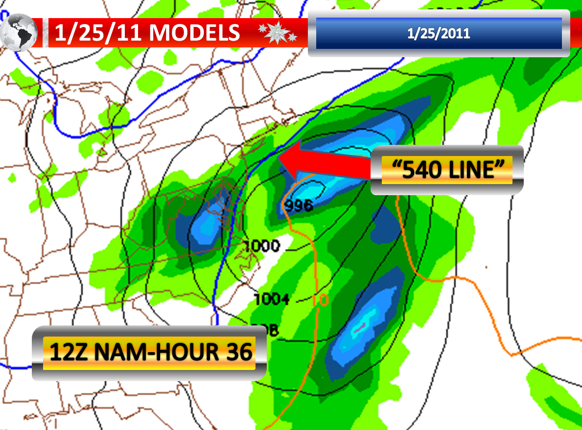
Then as the storm begins to intensify, expect everywhere to changeover to snow. The changeover will happen last in Atlantic, Monmouth, Ocean, and Cape May Counties. Some of the computer models show quite a bit of liquid available as the colder air enters our area, especially in New Jersey and Delaware, as the “540 Line” swings out over the ocean. Therefore a fairly decent amount of snow may fall in a three to six hour window of time at the end of the storm. This also raises the possibility of a flash freeze, which could set to happen around the evening commute and later further to the east. I think this will occur around 54 hours from this posting.