Showing posts with label Extended Forecast. Show all posts

Saturday, May 14, 2011

Showers and Thunderstorms For Six Days


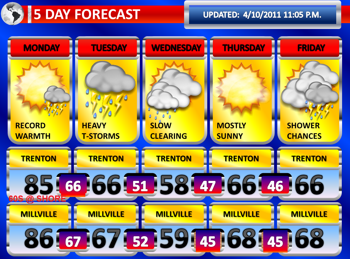
The omega block has broken down across our region and the result has been a return to unsettled weather conditions. An area of low pressure is now crawling from the Mississippi valley into the Ohio Valley. This low pressure area will crawl at turtle speed across the Ohio Valley as the atmospheric traffic jam continues and eventually it will arrive in Maryland. Basically, as slow as the high was in position over us, it will be that slow for the low before a push to bounce this jammed traffic out occurs late next week. Gulf of Mexico and Atlantic Moisture should be able to stream into our region for the next few days, particularly Tuesday and Wednesday. Initially, through Monday, the features will be more scattered and it will hard to pinpoint the exact area for development…but more widespread rains are likely Tuesday and Wednesday when the flow will be most enhanced.

Tonight, a MCV is affecting Washington D.C. and Baltimore with very heavy thunderstorms and some dangerous cloud to ground lightning. This area appears to be moving west of New Jersey at the moment. However, some scattered showers and thunderstorms were developing to the north and east of the MCV. Therefore, there is a 30% chance of a thunderstorm between now and the morning hours.

For (daytime) Sunday, the chances for scattered showers and thunderstorms look pretty good at this moment. There is probably greater than a 60% chance of showers and thunderstorms. I do see the potential for more organization and aerial coverage as the Sunday focal point will be stronger than the focal point that we have seen today. There should also be more instability in place on Sunday. Thunderstorms could very well be slow movers and they also will have access to some decent moisture to produce heavy rainfall. This raises the concern for potential localized flash flooding and excessive rainfall. Extensive cloudiness should limit the potential for severe weather to some degree. Any ongoing showers and thunderstorms in the morning would really limit severe weather. However, should there be some peaks of sunshine; a few severe thunderstorms could develop. The Storm Prediction Center has placed southern and western areas under a “see text” probability for severe thunderstorms within 25 miles of a point.

For Monday, another round of showers and thunderstorms is likely. The severe threat will be highly dependent on convective cloud debris and any potential ongoing action from the overnight. Hail and strong wind gusts appear to be the primary threats, especially if sunshine breaks out through the cloudiness. Any thunderstorm could contain localized heavy rainfall and they could be very slow movers suggesting localized flash flooding is once again not out of the question. There could be a little less in the way of activity on Monday.

For Sunday and Monday, while we do not have any flash flood watches in effect, I could see a few polygon warnings being needed. Sometimes, watches are not posted until the day of the event when there is higher confidence of the axis zone of organized development. History suggests the higher terrain influences, but it can happen elsewhere. The week of dry weather helped, but we are still running well above average in our basins with the wet spring season. The Raritan Basin is the most vulnerable to flooding this week...especially with 3" or more this week in one shot. All you need is a soaking MCV like the one tonight in Washington D.C. and then you have streams rising to bankful.

The stationary system and frontal boundary makes the closest approach on Tuesday and Wednesday. With the flow most enhanced at this point and time, this is when the heaviest rainfall will occur and the most widespread shower and thunderstorm activity of this entire stretch. The flood threat will be highly dependent on how bad the damage is done on Sunday and Monday. However, folks living in low-lying areas, along creeks, along streams, and along rivers should be aware that quite a bit of rain could fall in some communities on top of what falls prior to this time frame.

Residual moisture and effects from this system appear to linger into Thursday and Friday. While the coverage will be less, showers and thunderstorms are still a possibility, especially during peak daytime heating. At this point, a new powerhouse storm system will be taking shape in the Western United States and shift into the Central United States on Saturday. We will probably experience our first precipitation free day on Saturday (of the next seven). A pretty nasty severe weather outbreak may take shape in the Central United States next weekend if all the ingredients can come together. This system could impact our region by Monday according to the latest long range guidance, although it may be slower in arrival overtime and further adjustments could place this system in our territory Tuesday or Wednesday.

Please remember to turn around and don’t drown if you see rising flood waters. Also, if you hear thunder, you are close enough to be struck by lightning. Move indoors immediately when you hear thunder.

Friday, May 13, 2011

Several inches of rain possible the next 7 Days


Finally, we have some weather worth mentioning and discussing. After a very quiet period, the high pressure area that maintained control of fair weather in our region is breaking down. As the high pressure area breaks down, an area of low pressure will move from the Mississippi valley into the Ohio Valley. This low pressure area will move extremely slowly across that region as the atmospheric traffic jam continues. Basically, as slow as the high was in position over us, it will be that slow for the low before a push to bounce this jammed traffic out occurs late next week. Gulf of Mexico and Atlantic Moisture should be able to stream into our region for the next few days, particularly Tuesday and Wednesday. Initially, through Monday, the features will be more scattered and it will hard to pinpoint the exact area for development…but more widespread rains are likely Tuesday and Wednesday when the flow will be most enhanced.

At this point, isolated and in-significant rain showers are likely on Saturday. The models are no longer suggesting much for Saturday, delaying the arrival of this extremely slow moving weather pattern. It should be another mostly cloudy day with a peak of sunshine here and there.

For Sunday, the chances for showers and thunderstorms look pretty good at this moment. If some peaks of sunshine break through the clouds on Sunday and there is no thunderstorm activity ongoing, then some scattered severe thunderstorms would also be a possibility. Otherwise, any thunderstorm could contain localized heavy rainfall and they could be very slow movers suggesting flash flooding is not out of the question. As the case this week with the convection development that has been occurring with the same system, hail and strong wind gusts would be the main severe threats.

For Monday, another round of showers and thunderstorms is likely. The severe threat will be highly dependent on convective cloud debris and any potential ongoing action from the overnight. Hail and strong wind gusts appear to be the primary threats. Any thunderstorm could contain localized heavy rainfall and they could be very slow movers suggesting flash flooding is not out of the question.

The stationary system and frontal boundary makes the closest approach on Tuesday and Wednesday. With the flow most enhanced at this point and time, this is when the heaviest rainfall will occur and the most widespread shower and thunderstorm activity of this entire stretch. The flood threat will be highly dependent on how bad the damage is on Sunday and Monday. However, folks living in low-lying areas, along creeks, along streams, and along rivers should be aware. Some of our slower guidance keeps the chance for thunderstorms and showers for Thursday and Friday.

Friday, April 15, 2011

Major Storm Saturday P.M....Widespread Issues


A major rain and wind event is anticipated for Saturday, especially Saturday Night into early on Sunday Morning. The system has the potential to create moderate coastal flooding, damaging winds, flash flooding/flooding, and coastal flooding.

A strengthening low pressure system is moving eastward towards the Great Lakes and in response a cold front will approach our region on Saturday. A significant wave of low pressure is anticipated to develop along the front which will energize it further. A fetch off the Atlantic Ocean and support from the Gulf of Mexico should be capable of causing a huge intensification in the rain over our area. Therefore, several inches of rain may occur and it could come in a 6 to 12 hour period, introducing the possibility of localized flash flooding. At this point, 1.50” to 3.50” of rain is looking like a very good possibility. If the rain doesn’t fall quick enough for flash flooding, these rainfall amounts could be very well capable of causing creeks and streams to rise to or over their banks. The North American Model is showing a good slug of purple on the 18z run, therefore I think the proposal of an excessive rainfall event is gaining more confidence.

There is an opportunity for some strong winds across the region. A strong jet will develop aloft and maximize over our region during the evening hours. Heavy rain will transport the strong winds down to the surface, but even without the rain…some of this wind will be capable of mixing to the surface with the tightening gradient. Thunderstorms, which are expected to occur any time after 6:00 p.m., will be even more capable of producing damaging wind gusts. Right now, a widespread severe weather outbreak is expected south of the region by the Storm Prediction Center where sunshine and warmer temperatures will allow for more destabilization of the atmosphere resulting in stronger downdrafts. However, we could definitely see at least scattered thunderstorms with damaging winds and I will continue to monitor the latest forecasts from the Storm Prediction Center. Right now, South Jersey is under a “see text” or a 5% risk for severe thunderstorms. The National Weather Service has issued a wind advisory meaning conditions are imminent or occurring in which sustained winds of 31 to 39 MPH or frequent gusts of 46 to 57 MPH from Noon to Midnight on Saturday. This product is issued for non-convective wind potential. I think we may even see some areas, especially along the coast where the east-southeast wind could be the strongest, upgraded to a high wind warning. I can see some gusts maximizing to around 65 MPH. Inland, widespread 40 to 55 MPH gusts are expected…possibly higher with thunderstorms.

Huge impact on the Delaware River and Atlantic Coasts with coastal flooding: Widespread minor tidal flooding likely, at least scattered moderate tidal flooding likely...maybe even some major tidal flooding if gusts can reach 55 or 60 MPH at the shore

Power Outages: Certainly possible just with the wind, not adding the wet ground and the soaking expected.

Temperatures tonight will drop into the lower forties in many locations and slowly work their way through into the fifties on Saturday. Temperatures will reach their highest point Saturday Evening. The storm pulls away early on Sunday morning, with rain leaving the coastline by daybreak. Sunshine should follow with breezy conditions. Temperatures will rise into the sixties during the afternoon.

Sunday, April 10, 2011

Record Heat Monday...T-storms Monday Late into Tuesday


Record challenging high temperatures are anticipated for Monday, especially away from the coastline. Temperatures could approach 80 degrees or better once the sunshine comes out. I am still expecting a range of temperatures between 82 and 86 degrees. At the coast, the clearing will arrive last here and I also think the wind off the ocean will not be ideal for much better than 65-70 degrees.

On Monday Night, temperatures will be slow to cool. It is possible the readings drop a few degrees, before rising again ahead of a strong cold front arrive late Monday Night into Tuesday Morning. Thunderstorms may accompany the front. The models are not too robust with the convective activity and they are showing rapid dissipation with nightfall and as the thunderstorms enter into slightly more stable air near the Middle Atlantic Coastline. However, the nighttime temperatures of near seventy degrees will still allow for some instability to linger and at least some scattered severe thunderstorms may be possible.

The front may actually be more active on Tuesday as a wave of low pressure develops along the front as it slows down significantly over the region. There could be additional strong to severe thunderstorms on Tuesday, but there will be extensive cloudiness which could limit the potential. Heavy rainfall may be more of an impact on Tuesday. Several inches of rain could fall on Tuesday and may result in flash flooding. The first half of Wednesday could even be showery as the system takes time to gradually move out.

More showers and thunderstorms are possible on Friday with a warm front and on Saturday with a cold front.

Saturday, April 9, 2011

Extended Forecast for Sunday, April 10, 2011

As you may or may not know, I do the forecast for Phillyweather.net on Saturday Evening's. This is a plug for a very great site, rich in history about Eastern Pennsylvania, Delaware, and New Jersey for weather...in addition to excellent weather discussions! Check out phillyweather.net ....


Another severe weather outbreak from a potent feature has occurred today from Indiana down into South Carolina. This area has so far been getting hammered this past spring by severe thunderstorms and it appears that at least for the time being, this has developed into a weather pattern. Another outbreak of severe weather, potentially large, will develop in the northern half of the Midwest and this will slide east.

A warm front is moving northward and will arrive on Sunday Night. Ahead of the warm front, mostly cloudy skies and potential showers may develop. There could even be a few isolated thunderstorms on Sunday ahead of the front. All of this will slide to the north and east by early on Monday Morning.

The entire region should see skies clear on early Monday Morning, with northern sections observing the clearing line last. The sunshine will come out and the region will be entrenched well into a warm sector. Southerly winds, gusty at times, will pump in very warm air. Temperatures will likely range between 82 and 86 degrees across most of the region, with cooler readings in the Poconos. Some of our loyal site readers have done some research and have raised the prospect that we may squeeze out 90 degrees. At this point, I don’t believe it will be too widespread, but I will raise the maximum temperature to 86 degrees in Philadelphia. For Philadelphia International Airport, this could be a tricky scenario as a breeze off of the Delaware River could have a localized affect at the airport.

On Monday Night into very early on Tuesday Morning, a round of showers and thunderstorms is expected with a cold front. The cold front will likely arrive earlier in Central and Western Pennsylvania and this is where I anticipate a more widespread outbreak of severe thunderstorms. However, some instability will still be around in our region when the front arrives due to the near or actual record breaking temperature readings on Monday. Therefore, scattered severe thunderstorms are a possibility. It is still a little too early to speculate on the specific types of severe weather the region will see. Both the NAM and GFS really loose the convection at nightfall in our region.

Friday, April 8, 2011

Friday's Rain Givesway to Warm Times Ahead


A wave of low pressure continues to ride along a stalled frontal boundary. This system is bringing rain to our entire area. South of Interstate 195, the rain may be heavy at times. The NAM is indicating some colder air developing aloft this evening and the heavier bursts of rain may contain some sleet pellets or wet snowflakes. The rain will taper off to drizzle early on Saturday Morning before gradual clearing takes place.

There is a change in the forecast for Sunday. The modeling has delayed the warm front arrival until Sunday Night. This means Sunday will be cooler than previously forecast. It also means that Sunday Morning will be dry and now we are looking for some isolated showers or thunderstorms Sunday Evening into early on Monday Morning.

At this point, the warm front should clear Monday Morning and I am still expecting a very warm day with highs in the middle eighties in much of Central and Southern New Jersey. Should the warm front fail to clear the region, a few degrees could be shaved off the temperatures predicted.

Showers and thunderstorms will arrive Monday Evening and Monday Night, perhaps lingering into early Tuesday Morning. The exact timing will make a difference with the potential for severe thunderstorms. At this point, if they occur during nightfall, the likelihood of severe weather will decrease some. However, instability will not totally wane this quickly and some scattered severe thunderstorms are probable. The timing of the thunderstorms could move up and this may have an adverse effect on the high temperatures and severity of the storms.

Thursday, April 7, 2011

Record Warmth Expected on Monday---T-Storms Monday Night


Not much change from the previous forecast two days ago with the overall expectations of the weather features. A stalled frontal boundary will allow a wave of low pressure to ride along it on Friday. A cool, easterly flow will make for a miserable day. It will feel damp and cool with an east-northeast breeze. Rain should build in and if it is not raining, it will likely be drizzling.

On early Sunday Morning, a warm front will lift through the region. The warm front could be preceded by isolated showers and thunderstorms. The showers and thunderstorms along with clouds will likely clear the region by mid-morning and sun will appear from south to north. As the front clears, the sunshine will combine with a strong southerly flow to cause temperatures to accelerate. Middle seventies look very reasonable and I could see some locations in Southern New Jersey reach near 80 degrees.

On Monday, temperatures will soar into the middle eighties and we could potentially see some upper eighties. A cold front will approach at night into early Tuesday Morning. This timing, if it does not move up, will allow us to once again miss the brunt of what could potentially be another outbreak of severe weather to our west. However, with such warm temperatures expected even at night and at least some instability lingering from the intense April heat, I expect at least some scattered severe thunderstorms. The cold front and thunderstorms will bust the record warmth. However, temperatures will be in the sixties and seventies afterwards.

Tuesday, April 5, 2011

Severe Wx Outbreak for U.S. One of the Biggest Ever


On this blog, I discussed the potential for a major severe weather outbreak, particularly south and west of here for several days. Now that the dust has settled, more than 1,200 preliminary reports of severe weather, according to the Storm Prediction Center, occurred. This is one of the highest numbers ever recorded for a single day. There were 32 reports of tornadoes, 1312 reports of wind damage, and 89 reports of large hail. Today, there were 50 reports of wind damage and there was 1 report of large hail.

An unsettled pattern is expected for our region. A cold front will swing through the region tomorrow night. The front is expected to stall to our south and allow numerous disturbances to ride along it. The result will be periods of showers. On Friday, a more organized area of rain and possibly a few rumbles of thunder may occur. Then a warm front lifts northward Saturday Evening into early on Sunday Morning. This will allow for showers and thunderstorms during that period. Then Sunday will be mostly sunny and a very similar day to Wednesday of this week with increasing sunshine and very warm readings. At this point, with the distance we have, I won’t go with lower eighties…but Sunday could very well end up being that warm.

Sometime during the time frame of Monday, a strong cold front is yet again forecast to move into the region. The timing will make all the difference. However, somewhere along the eastern regions of the United States is expected to see another outbreak of severe weather. It is day six in the forecast period and therefore more details will be forthcoming tomorrow.

Today's wind gusts:

NEW JERSEY

...ATLANTIC COUNTY...
ATLANTIC CITY AIRPOR 40 1159 AM 4/05

...BURLINGTON COUNTY...
RED LION 44 1030 AM 4/05

...CAPE MAY COUNTY...
CAPE MAY 56 1155 AM 4/05
OCEAN CITY 52 715 AM 4/05

...CUMBERLAND COUNTY...
BIVALVE 48 1030 AM 4/05
MILLVILLE AIRPORT 43 1133 AM 4/05

...MERCER COUNTY...
TRENTON AIRPORT 41 1046 AM 4/05

...OCEAN COUNTY...
TUCKERTON 51 735 AM 4/05
HARVEY CEDARS 41 1100 AM 4/05

...SOMERSET COUNTY...
HILLSBOROUGH 40 1030 AM 4/05
SOMERVILLE AIRPORT 39 1032 AM 4/05

...SUSSEX COUNTY...
HIGH POINT 49 1030 AM 4/05

Not sure whether winds played a role in the nearly 10,000 customers who lost power in the Howell and Jackson areas today or not....

Monday, April 4, 2011

Windy Early Tuesday with Thunderstorms


A large severe weather outbreak is in progress from Ohio and West Virginia down through Louisiana, Alabama, and Georgia. These thunderstorms have formed in advance of a powerful cold front being dragged right into a very decent warm sector. With nightfall, instability will wane to some degree. Therefore, as the activity slides eastward towards the Eastern United States, it should weaken. However, strong wind fields aloft suggest the potential will still be there for scattered severe thunderstorms with damaging wind gusts when the storms arrive early on Tuesday Morning. The winds are strong enough aloft that it will not take the most organized thunderstorm to produce strong surface wind gusts. At this point, the modeling is suggesting the greatest potential for strong to severe thunderstorms south of Interstate 195. But, one could form virtually anywhere.

A wind advisory has been issued for all counties south of Interstate 195 for Tuesday Morning. The winds look to increase ahead of the front with gusts removed from thunderstorms near 45 or 50 MPH. The thunderstorms may also contain frequent wind gusts of 45 to 50 MPH. Severe thunderstorms are categorized as storms that produce 58 MPH or greater winds, large hail of 1.00” in diameter or greater, and/or a tornado. I also wouldn’t be surprised if there is another two to three hour burst of gusty winds behind the cold front.

Sunday, April 3, 2011

Windy and Very Mild Monday

Monday: Early showers/thunder....becoming mostly sunny...66 in far NW to 80 South. Very windy. Gusts between 40 and 45 MPH, as high as 50 MPH.

Monday Night into Tuesday Morning: Windy, Possible Strong T-Storms...Isolated Severe.

Tuesday Morning into Tuesday Evening: Cooler and windy. Wind gusts up to 50 MPH from the NW. 57-64 early...then dropping in the aftn.

Wednesday: Sunny in the morning...late showers.

Thursday: Breezy and mild.

Friday: Showers and thunderstorms.


A wind advisory has been posted for Southeastern Burlington, Atlantic, Cape May, and Cumberland Counties for Monday Afternoon into Monday Evening. It is quite possible that the wind advisory area is expanded. I am expecting strong winds, if not high winds, across much of my website viewing area Monday Afternoon into Tuesday.

A strong warm front will lift northward early on Monday Morning. The warm front may initially struggle to lift northward, but it will be well north if the models are correct by the late morning hours. Meanwhile, a potent low pressure center will intensify and deepen north of the Great Lakes in Canada. The low will energize a cold front and drive into the warm sector, causing a line of severe thunderstorms to develop as the difference in air masses clash.

The potent low pressure center will work with other various factors to really tighten the pressure gradient across the region. The American computer models, both the NAM and GFS, have had a diamond shape look to the wind gradient for days now. This setup is usually results in strong winds aloft. There are two typical ways to tap into the strong winds aloft. This can be done by mixing and by convection firing up. We may have both occur.

By Monday Afternoon, especially south of Route 1, temperatures will surge as skies may become mostly sunny. The sunshine and rising temperatures will begin to mix the air and this may transport these strong winds to the surface. Winds will become sustained between 20 and 35 MPH with gusts to 50 MPH. The highest chance is over the wind advisory area, but I can see the wind potential developing across the entire region should sunshine break out even in Northern New Jersey. Some portions of South Jersey could reach near 80 degrees. I’ll have to watch Trenton. Last time, even Trenton reached 80 degrees with a strong southerly flow about three weeks ago. At the very least, lower to mid seventies region-wide can be anticipated. Sixties are likely, perhaps better, in far Northern Jersey.

Very mild temperatures and strong winds will pose the risk for increased fire danger. The moisture content of the air is questionable with a gulf flow, but the wind speeds and warmth may makeup for that.

On Monday Evening, the winds may subside with the loss of sun and nightfall. However, it is possible that the approaching cold front from the west will maintain the strong, gusty winds. At this point, I am thinking a lull could happen for a few hours before another strong gust with the frontal arrival late into early on Tuesday Morning. The late arrival of the cold front is going to mean New Jersey will escape widespread severe weather that will be ongoing in Western and Central Pennsylvania. As the overnight progresses, instability should wane to some degree. However, despite waning instability and weakening convection, the winds will be strong enough aloft that some thunderstorms that are still organized will be able to pull strong winds to the surface and this means isolated severe thunderstorms are possible. Damaging winds would be the main threat, although shear may pose the risk for a tornado. Some small hail may also occur. Southern areas would have the greatest chance of severe weather.

Colder on Tuesday behind the front and thunderstorms, and it could become windy once again as we will be in the western half of the diamond shape. Behind the front, the gusts will come out of the northwest and once again could be as high as 45 or 50 MPH.

Saturday, April 2, 2011

Wild First Half of the Week


A disturbance moving in for the remainder of today will cause some showers, especially in Southern New Jersey. Based on the late morning soundings and observations of cloud growth, some isolated thunderstorms are not out of the realm of possibility. With a low freezing level today, some hail would occur if there is any thunderstorm. With daytime heating coinciding with the disturbance, numerous clouds will result in mostly cloudy skies.
I am still confident that Sunday will be the sunniest day of the next three, especially in the morning hours. By Sunday Evening, clouds will be developing in response to an approaching warm front.

I am still expecting a warm front to produce rain on Monday and possibly some thunderstorms. If the warm front and associated clouds clear the region by the afternoon hours, temperatures could soar once the sunshine comes out.

The main change from my forecast yesterday is the timing of the cold front is about twelve to fifteen hours earlier on the latest guidance, a trend that began yesterday. A potent low pressure that will intensify in Canada will push a strong cold front into the warm sector on Monday Night into Tuesday Morning. The model guidance indicates thunderstorms and heavy showers preceding the front. With high shear and strong winds aloft, some severe thunderstorms are a certainty. A more widespread severe weather outbreak in our region will hopefully be precluded by the nighttime arrival with waning instability at night. On Monday, in areas where the sunshine breaks out, the tightening gradient and decent mixing could allow for wind gusts at the surface to be pretty robust. On Tuesday, behind the front, pressure falls and a tight gradient on the back-side of the front could allow for another dose of strong wind gusts. The timing change also means that Tuesday will be cooler now and that Monday will be the warmest day of the period. This makes temperatures even trickier as they will be dependent on the clearance speed of the warm front, which may get hung up in Northern New Jersey.

Friday, April 1, 2011

70s in the forecast, no fooling


On Saturday, there will be a few disturbances which could lead to a few snow showers or rain showers. Sunday will feature more clouds then sunshine as our next system moves in on Monday. Sunday Morning will probably feature the most sun of the next several days.
On Monday, a strong warm front will lift through our region. Rain with an isolated thunderstorm is possible.

On Tuesday, a strong low pressure system will pass to our north and swing a powerful cold front into our region on Tuesday Night. The low pressure area is currently projected to really intensify and become potent. This will generate a strong wind field aloft as the pressure gradient looks pretty ominous on the modeling. With the warm front lifting well to our north on Tuesday, strong southerly winds will develop and bring a strong push of very warm air into the region with high temperatures pushing into the seventies ahead of the cold front. The sunshine will probably lead to surface wind gusts of around 45 mph, at least, as the mixing occurs. Then as the cold front swings in late in the day, a round of potential severe thunderstorms with damaging winds could occur. There could even be some large hail and/or an isolated tornado if the time frame of the line of thunderstorms is moved up into the evening hours.

A major severe weather outbreak will occur both on Monday and Tuesday in the eastern half of the United States, with the best chances across the Mississippi Valley into the Ohio Valley.

Thursday, March 31, 2011

Active 7 Days


This is still looking like a “not a big deal” type of weather event this evening. Rain overnight will intensify as the coastal storm beings to take shape off the Carolina Coastline and move northeast. The best dynamics are offshore and will shift up to New England where they should take a pounding.

So, rain, heavy at times overnight into early Friday Morning. The rain may change to wet snow showers north of the Atlantic City Expressway and most likely north of Interstate 195 during the morning hours. The worst case scenario may result in a quick slushy coating to a few inches in Central New Jersey, primarily on grassy surfaces. The best opportunity for colder air to make it this far south would be when the low pulls away. Otherwise, the models have even lowered the liquid to work with today even more, so now rainfall amounts of around three-quarters to one-inch can be expected.

Outside of the main website viewing area, some accumulating snow will occur in Northwestern New Jersey after a change from rain. AT BEST this is a moderate snow event for them, with up to six inches possible there. The late afternoon runs gave some renewed hope to allow for 5 or 6 inches to remain in the forecast up there…earlier runs this morning said even 4 inches was optimistic.

There still could be a period of gusty winds along our eastern counties. Wind gusts of 35 to 45 mph would be possible, especially along our coastal communities. The east-northeast flow will impact our coastal areas with spotty tidal flooding of minor severity.
As the storm pulls away, the low is expected to intensify further off the coastline of New England. The result could be a very stuff northwest wind developing. Wind gusts across the entire region may exceed 50 MPH behind the storm. Drier air will filter in, but some lingering instability and backlash could produce some snow flurries and snow showers.

Snow showers or rain showers with a clipper is possible on Saturday.

Heavy rain on Monday is possible with a warm front and wave of low pressure.

Thunderstorms, possibly severe, is possible on Tuesday on Wednesday with a mild surge of air.

Tuesday, March 29, 2011

2 Storms, Numerous Uncertainties


The first system will be affecting the region Wednesday Afternoon into early Thursday Morning. The latest computer modeling has shifted this storm northward. Still, the majority of measurable precipitation will fall south of Interstate 195. In the regions that will have the coldest temperatures in the upper atmosphere the precipitation intensity will be very light. The light intensity will make it hard for colder air aloft to drag to the lower levels of the atmosphere and this means there could be patchy drizzle instead of light snow or flurries. In areas that may see steadier precipitation, the temperatures will be warmer and despite the intensity, it may not snow but rather rain. The area to watch will be between Route 1 and the Atlantic City Expressway. Should there be heavier precipitation in this area for a few hours, after the sun settles for the night, some snow is possible and it could accumulate on grassy surfaces. Meanwhile, it will also have to be determined whether the immediate surface temperature eventually drops in Central New Jersey to the freezing mark which would allow the potential for some freezing drizzle. In Northwestern New Jersey, whatever makes it into these areas would probably be in the form of snow as here the temperatures would be cold enough in all levels regardless of the intensity.

The true forecasting nightmare arrives Thursday Night and lingers into Friday. A Nor’easter is possible. The models have been flopping on the storm track and intensity. This is critical to know for me to determine the precipitation type and air temperatures at various levels. The late afternoon GFS guidance was a bit warmer than the early morning guidance. At this point, the onset may be start as snow in the Northwest New Jersey regions with rain, possibly mixed with sleet and wet snow elsewhere. Then, it may rain for the remainder of the event in most spots before potentially ending as wet snow. There was one ominous model run of the GFS this morning which indicated the potential for a mix changing to a wet snowstorm for much of the region and for now that will be considered an outlier. Whatever precipitation falls, there appears to be a 6 to 12 hour period for it to be heavy at times and combined with strong winds. Of course you have the late afternoon NAM model which doesn’t show much of a storm at all. This portion of the forecast remains challenging and once again huge and drastic changes may be in store in future forecasts in both measurable amounts and temperature.

Monday, March 28, 2011

Trickly Forecast Wednesday into Saturday


As mentioned yesterday, there have been some changes made to the extended forecast graphic. Throughout the past few months there have been some great temperature differences from Trenton to Cape May, in some cases a difference by more than twenty degrees. With expected swings from north to south expected the remainder of this spring and summer sea breezes, a change to the graphics was necessary. The top row of numbers will be the forecast for the Trenton area and the bottom numbers will be the forecast for the Cape May area. Unfortunately, there could even be some differences in between these two cities and to account for this there is yet another change. Every forecast will come with a regional weather forecast for 24 hours out. This is the best compromise that could be hammered out at this time. If you have any suggestions, please email them to doug@phillyweather.net.

The forecast for the remainder of this week is very uncertain after tomorrow night. There is confusion building for both the mid-week system and the late-week systems on the computer modeling. It all has to do with the extent of the dry and cold air now in place across our region and when this finally erodes.

I suspect Tuesday will be another party sunny day, with mostly sunny skies in some areas. With the air remaining dry and wind gusts of 10 to 20 mph, some elevated fire danger continues. Another red flag warning type day is possible. There are rumblings a fire weather watch may replace the current red flag warning when it expires. Again, our Central New Jersey counties remain fairly moist. I was walking through a field yesterday and I obtained mud on my shoes up in that region. It will also remain well below average in the temperature department, another limiting factor. So like today, I don’t see the most ideal or critical fire weather situation transpiring.

For Wednesday, there are major questions at this point. The North American Model is suppressing the area of low pressure to our south. The Global Forecast System model is now not too robust with the northward extent of this system either in the latest modeling. So, it appears Wednesday is cold, possibly mostly cloudy, and there could be some flurries or snow showers, especially towards evening or at night. Some models are suggesting the snowflakes melting in the upper levels, but not enough cold air to refreeze the drops to form sleet. Therefore, there could be some drizzle droplets. Areas, especially north of 195, could experience freezing drizzle if this was the case as below freezing temperatures may be found once again at the immediate surface. Wednesday-Wednesday Night has the potential to be much drier and see the comments at the end of this post. One high resolution model I use shows some snow bursts around Ocean and Burlington Counties around 10 p.m. Wednesday Night.

On Thursday Night into Friday, the Global Forecast System model shows a coastal storm affecting the region with a mixture of rain, sleet, wet snow, and freezing rain in Northwestern New Jersey and rain…initially starting as a mixture in some areas…elsewhere. However, should this storm “bomb out” and track a certain way as some model guidance is hinting at, the storm could potentially be colder in nature and I could see a few portions of New Jersey piling up snow if this was the case. Wind, precipitation type, surface temperatures, tidal effects, and storm track is still very uncertain.

Wednesday through Saturday could need huge and dramatic temperature and precipitation adjustments in later forecasts that I issue. Take note.

Sunday, March 27, 2011

Late Week Questions

Today turned out to feature a lot more sunshine than previously anticipated as the southern storm system cleared much faster than previously expected. The extra sunshine allowed temperatures to push into the forties. Tonight, under the clear skies, temperatures should drop into the twenties area wide. Snow remains a factor in Northwestern New Jersey which could cause temperatures to drop into the teens in these regions.

With a continuing Greenland block, dry air and below average temperatures will remain in place for Monday and Tuesday. The Canadian high pressure area will gradually ease on Tuesday Night into Wednesday.

The latest computer model guidance has been hinting at a potential for a storm system for the middle of this week and perhaps a second storm system late in the week. There has been a good deal of uncertainty over which of the two storm systems would be the bigger and stronger of the two. The stronger storm some of the models hint at for Friday would require a weaker midweek storm. A stronger midweek storm would most likely limit the potential for the strong energy to develop in time for Friday. Of course strength and positioning would determine key factors such as precipitation types, wind speeds, measurable amounts, and surface temperatures. It is too early to predict all of these factors with great confidence since there is considerable uncertainty.

I’ll keep a sharp eye on the long range guidance as these two potential systems approach. The extended forecast graphic will return tomorrow as a slight modification and redesign is underway to provide greater accuracy.

Friday, March 25, 2011

Southern Brush This Weekend


A weak disturbance passing south of Trenton tonight will cause an increase in cloudiness and perhaps trigger some flurries or a snow shower. Unless something unexpected occurs, most areas should just see a few flakes in the air.

On Saturday, skies should clear by mid-morning, become sunny for a time, and then more clouds ahead of a southern storm will move in by evening. The skies will range from partly cloudy in the evening north and mostly cloudy south.

The southern storm will be passing to the south of New Jersey on Sunday. If the latest modeling is correct, there could be no measurable precipitation even in extreme southern portions of New Jersey. Glimpses of sunshine are possible north, while overcast skies are likely south. With snow cover far north, we may not see warmer temperatures despite more sunshine. Thirties appear likely in the snow covered regions north and in the overcast regions. Central New Jersey could push 40 degrees if there is sunshine. But given several factors, I am forecasting the middle thirties now for high temperatures. I will leave the chance for a southern flurry in the forecast or isolated snow showers, but at this point the chance for snowflakes is decreasing dramatically.

Slightly warmer, but still well below average temperatures will occur Monday, Tuesday, and Wednesday. On Wednesday, some rain is likely with the next system. There could be some mixing initially across northern sections of the state. A few models are colder and further south, which would introduce more widespread mixing chances.

Thursday, March 24, 2011

Clearing Skies


The terrifying tornado in Western Pennsylvania covered in an earlier post today has now been rated an EF2 on the Enhanced Fujita Scale. An ominous photograph has surfaced this afternoon, courtesy of the National Weather Service Forecast Office in Pittsburgh. 146 tornadoes have been recorded in New Jersey since 1950. Now, 740 tornadoes have been recorded in Pennsylvania. Some tornadoes are of higher impact because of what they impact and how long their path of destruction is. In this case, the path length was 7 miles.

Otherwise, you can see on the satellite imagery that sunshine has been slowly increasing to our north. It will likely not reach into portions of Southern New Jersey before the sun sets this evening. This means the day will go down as overcast in the portions of the south. Friday at this point will have some sporadic clouds.


The picture for the week is beginning to become clearer. It appears as though a wave of low pressure will pass to our south on Sunday. Clouds will increase on Saturday Evening and Sunday should be mostly cloudy. Some of the models are suggesting some precipitation brushing our southern counties on Sunday and with cold air entrenched and a storm track so far south, what does fall may be in the form of wet snow or sleet. We will need to watch any northward progression of the storm system which could result in a more widespread impacting event, but perhaps a slightly warmer one.

Wednesday, March 23, 2011

Different Weather Conditions Across NJ Tonight-Thursday AM


All eyes are on an area of low pressure across the Ohio River Valley that is projected to move eastward this evening. Numerous heavy showers and thunderstorms have developed along the corridor in which the low pressure area is moving and this activity will move eastward. Low-topped convection is likely later tonight into early Thursday Morning. With a low freezing level, despite marginal instability, some of the thunderstorms have the potential to produce hailstones. Some of the hail could be of penny or nickel size in the strongest thunderstorms. I have noticed the recent severe thunderstorm watch issuance for portions of Central Pennsylvania, where it is only 40-45 degrees for an air temperature. By Pittsburgh where the storms are right now it is 60-68 degrees. It may be possible some of the hailstones reach quarter size which would be the threshold for a severe thunderstorm classification. The best chance for thunderstorms is south of the Interstate 195 corridor. With temperatures so cold however, lack of sunshine, and night arrival of the storms…I am hopeful the thunderstorms will be isolated in nature. This will be an evolving situation. It wouldn't shock me if a warm slot of 50 degree air suddenly pushed into South Jersey ahead of the front...that is just another factor to watch...

Otherwise, the additional showers moving eastward will move into the colder air in Northern and Central New Jersey. This will allow for periods of wet snow and sleet, possibly mixing with rain. In Northwestern New Jersey, this will be all wet snow. It should be noted that the NAM is still indicating (although not as aggressive) a brief period of wet snow in areas north of the Atlantic City Expressway on Thursday Morning. A period of wet snow and sleet is possible in these areas, but everything has to fit in line perfectly.

A large spread is on the computer modeling for this weekend and early next week with regards to two separate storm systems. Mixed precipitation or snow is possible should there be measurable precipitation.

Tuesday, March 22, 2011

Spring Season Mixture, For Others Just Damp


Passaic and Sussex Counties have been placed under a winter storm warning. Bergen, Hunterdon, Somerset, Warren, and Morris Counties have been placed under winter weather advisories.

Precipitation will likely develop by daybreak into the mid-morning hours. Initially, it may be light enough for it to just be some light drizzle or misting. I am still expecting a burst of heavier precipitation as the first low pressure system rides along a stalled frontal boundary to our south. The heavier burst of precipitation could drag colder air down through the column. The result will be rain mixing with wet snow and sleet at times.

In Northern and Central New Jersey, there is the potential for enough cold air to be pulled near the surface for a total changeover to wet snow. The colder North American Model continues to suggest that it will remain wet snow, possibly mixed with sleet once this happens north of Interstate 195. Other high-resolution modeling and the Global Forecast System modeling shows warmer air eventually taking back over. My thinking is that even if the precipitation type remains wet snow, air temperatures at ground-level will rise a few degrees above freezing during the daytime hours and the strong late March solar radiation will go to work preventing large amounts of accumulation. I think in most of North and Central New Jersey, an inch or two of slush could occur with the worst case scenario in the morning hours. Higher elevations and Northwestern New Jersey could see amounts as high as four to six inches during the morning and afternoon. Additional snow accumulation is possible at night into Thursday Morning should there be a second piece of energy which energizes the original low. Meanwhile, in South Jersey, this is mainly rain for the morning and afternoon with a bit of mixture and if the air is warm enough…even portions of Central New Jersey could end up being mainly rain.

A second piece of energy will develop Wednesday Night into Thursday Morning. This will reenergize the initial low offshore. The result will be colder air coming back into the areas that switched from snow to rain during the midday hours. Even southern areas may eventually end as some wet snow and sleet. The latest 18z NAM model has backed off on the extent of backend snow and colder air and brings the possibility of a heavy burst of snow as the storm ends down into Central New Jersey and possibly the northern portions of Southern New Jersey. Meanwhile, none of the other models really show robust development with the second piece of energy. Anyone living north of the Atlantic City Expressway should keep an eye on the developments tomorrow morning for the second piece of energy as the NAM has had fairly good credibility this winter.

Colder air aloft on the remainder of Thursday could cause several pockets of snow showers and flurries and bubble up quite a bit of clouds after a few peaks of sunshine behind the morning precipitation. It may also be blustery.

More storminess, potentially frozen precipitation, is possible over the weekend. Temperatures will be running well below the average high of around 53-54 degrees for late March.