Showing posts with label Winter Storm Potential. Show all posts

Tuesday, March 22, 2011

Update on the Wintry Weather Threat


No real big changes.

A winter storm watch was issued about 3 hours after my early morning post for Northwestern New Jersey. This area will see wet snow much during this event, perhaps mixed with sleet and freezing rain during the afternoon before changing back to wet snow.

Otherwise, we need to watch closely whether the NAM model is correct about a heavy burst of snow even in portions of Southern New Jersey during Wednesday Night into Thursday Morning. The National Weather Service may eventually need a watch for this part of the storm as the criteria is 4" of snow or more, lower than Northern and Central New Jersey where the criteria is 6".

I'll have a complete update later this evening.

Check the new promo. The end is cut off, but there was a good ending.

Tuesday, February 22, 2011

Another Big Mess on Friday


Attention turns to the storm on Thursday Night into Friday. An area of low pressure will be sliding across southern portions of West Virginia. Then the storm is expected move across Maryland and Delaware into New Jersey, before sliding offshore. This would bring the heaviest axis of precipitation right over the region. Two to three inches of rain are certainly possible on Friday where it is all rain except at the ending. The snow in North Jersey and South Jersey also has to be taken into consideration. The creeks and streams are already running at or above normal from the recent melting snowfall. All of this suggests possible flooding of at least the smaller creeks and streams on Friday Night into Saturday as the rain water runs off.

Another concern I have is in Northwestern New Jersey, where we could have some potential freezing rain, wet snow, and sleet. With a lot of available liquid, even six hours of freezing rain could quickly result in one-quarter to one-half inch of ice. The snow on the ground in this location could also aid in holding colder air, in addition to the higher terrain benefits. If the 12z GFS is correct, the temperatures may never get above freezing before the ice or wintry mix changes to snow in the final stages of the storm.
But there is more. The 12z NAM and the 12z GFS shows a transition to sleet and wet snow as the storm pulls away (for most of New Jersey) and rapidly intensifies off the Massachusetts coastline, with possible accumulations. The temperatures drop quickly behind the storm, suggesting some potential flash freezing. We have forty-eight hours to see if this storm is actually going to end with several inches of snow or if this is just a false suggestion. The 12z NAM gives us about 0.25” to 0.50” of liquid to work with when the “540 Line” drops through to Cape May County. Without ground temperatures or transitions taken into consideration, this would equate to 3 to 6 inches of snow. The 12z GFS shows this transition happening even faster during the course of the storm, with heavy rain changing to heavy, wet snow in Central New Jersey and then eventually in Southern New Jersey.

There will be a lot to iron out here.

The blue line before the orange line is the “540 Line”.

Tuesday, February 1, 2011

Ice Storm Warnings Issued for North Jersey

There have been some additional changes to the advisories, watches, and warnings across New Jersey.

A winter weather advisory remains in effect for Ocean, Burlington, Camden, Gloucester, Monmouth, and Salem Counties. This is for part one of the storm which is in progress with freezing drizzle. A warning was dropped for Hudson County in North Jersey and an advisory is now in effect there.

A winter storm watch remains in effect for Ocean, Burlington, Camden, Gloucester, Monmouth, and Salem Counties.

A winter storm warning remains in effect for Middlesex, Mercer, Warren, Morris, Hunterdon, Somerset, and Sussex Counties.

An ice storm warning has now been issued for Passaic, Bergen, Essex, Union, and Hudson Counties. the winter storm warning is cancelled as freezing rain will be the main issue now for these areas.

Turning Attention to Part 2

Part one of the storms did not live up to the forecast as the snow and sleet was minimal in Central and Southern New Jersey. Many picked up a coating of snow which was followed by light freezing rain and freezing drizzle. The light icing made for a difficult morning commute.

Temperatures are now rising above freezing in most of the area. The big question tonight will be which locations will drop a few degrees with the diminishing daylight. For some areas, this could be extremely close as 32/33 degrees makes all the difference between an ice storm and a heavy rain storm. The high resolution models continue to indicate icing north of the Atlantic City Expressway and west of the Garden State Parkway. More serious icing continues to appear as though it will affect Northwestern Central New Jersey into Northern New Jersey.

The warm air aloft has even begun to impact the northern counties so it looks as though the snow will even be minimal there. Sussex County has temperatures in the teens, so some snow could still be falling in that county. Should there be rain, it will be quite dangerous up there.

A winter storm warning has been continued for Sussex, Hunterdon, Somerset, Warren, Morris, Mercer, Middlesex, Passaic, Essex, Union, Hudson, and Bergen Counties. This is for both part one and part two of the storm.

A winter storm watch has been continued for Burlington, Camden, Gloucester, Salem, Ocean, and Monmouth Counties. This is for part two of the storm only.

A winter weather advisory has been continued for Atlantic, Burlington, Camden, Gloucester, Salem, Ocean, and Cumberland Counties. This is for part one of the storm only.

Criterion:

A winter storm warning means four inches or more of snow or sleet and/or 0.25” or greater of ice accretion is imminent or occurring. North of Interstate 195, the criteria for snow is six inches.

A winter storm watch means four inches or more of snow or sleet and/or 0.25” or greater of ice accretion is possible. North of Interstate 195, the criteria for snow is six inches.

A winter weather advisory means two inches of snow or sleet/and or 0.01” to 0.24” of ice accretion is imminent or occurring. North of Interstate 195, the criteria for snow is three inches.

Monday, January 31, 2011

Major Winter Storm To Strike New Jersey


Thanks for your waiting...Blog Finished.
A winter storm warning has been issued for Sussex, Hunterdon, Somerset, Warren, Morris, Mercer, Middlesex, Passaic, Essex, Union, Hudson, and Bergen Counties. This is for both part one and part two of the storm.

A winter storm watch has been issued for Burlington, Camden, Gloucester, Salem, Ocean, and Monmouth Counties. This is for part two of the storm only.

A winter weather advisory has been issued for Atlantic, Burlington, Camden, Gloucester, Salem, Ocean, Cape May, and Cumberland Counties. This is for part one of the storm only.

Criterion:

A winter storm warning means four inches or more of snow or sleet and/or 0.25” or greater of ice accretion is imminent or occurring. North of Interstate 195, the criteria for snow is six inches.

A winter storm watch means four inches or more of snow or sleet and/or 0.25” or greater of ice accretion is possible. North of Interstate 195, the criteria for snow is six inches.
A winter weather advisory means two inches of snow or sleet/and or 0.01” to 0.24” of ice accretion is imminent or occurring. North of Interstate 195, the criteria for snow is three inches.

A serious and very dangerous winter storm is about to impact New Jersey. This storm will bring different weather elements to different parts of the state. From surveying members of the public today, they are very confused about what to expect. There simply is not enough time to explain all the details for each part of the state on television or radio. So I will try to break things down here the best I can.

I am expecting snow to break out across much of our region late tonight into Tuesday Morning. The snow is the result of warmer air riding over colder air. This is called overrunning induced precipitation in meteorology. Eventually, the warmer air will cause the air aloft to rise above freezing and this will begin to melt the snowflakes. However, cold air will hang tough at the surface and below freezing temperatures will remain stubborn in the interior. Therefore, freezing rain can be expected. The layer of below freezing temperatures at the surface at first may be large enough for the raindrops to refreeze before hitting the surface. This is sleet. Otherwise, raindrops will freeze when they make contact with a below freezing surface making it freezing rain. As the warmer air makes inroads aloft, the precipitation intensity will lighten and shift northward. Therefore, Central and Southern New Jersey may only experience freezing drizzle into the evening. The precipitation should remain snow for much of Tuesday in the higher terrain and this is where the heaviest available liquid is expected to be. Therefore, I still expect four to eight inches of snow in this area. My snowfall map remains unchanged. Some portions of New Jersey below Interstate 195 could rise a degree or two above freezing as the precipitation intensity lightens. However, temperatures will drop as the sun begins to set slightly and this will mean temperatures falling down below or at freezing in time for part two. The more mixing we see, the less snowfall we will get. This makes for a tricky forecast for snowfall totals.

The second part of the storm is an inland coastal low pressure area. This will be passing to our west and then over/just north of the region on Tuesday Night into Wednesday. The position of the low pressure area places New Jersey on what is considered the “warm side” of the storm. This will take a warm front and try to lift it up through the state from the southeast. However, how far inland and how fast that warm front moves through the state is in question. I have a feeling that this front will have difficulty lifting up through the area. We could have 20 degree difference in temperature from northwest to southeast. The shore could see some 50's on Wednesday with t-storms. The snowpack and an area of high pressure hanging tight to our north initially will continue to make it difficult for the temperatures to warm at the surface in the interior. This is especially true for areas with a northeast wind. This is what we call cold air damming. Therefore, more freezing rain can be expected. I expect this to give way at some point South and East of Trenton, but even along Routes 70, 73, 206, and 130…this may take several hours. The beginning of the second part may have some fairly good available liquid, so even here one-quarter of an inch of ice or more could accumulate before a change to plain rain. Any plain rain that occurs on Wednesday Afternoon could be very heavy and combine with the snow and ice to cause flooding problems. Meanwhile, areas that do not see a change to rain will see a crippling ice storm.

For the flooding potential, the greatest amount of plain rain will be in areas with the least snowfall and the sandy soil. However, should heavy rain impact areas around the Delaware and Raritan Basins, more significant stream, creek, and river flooding would be likely. I think the greatest flooding issue will be poor drainage flooding as the ground is frozen and covered in snow and many roadway drains are blocked by the snow and ice.

Winds could become gusty for a time on Wednesday, especially as the warm front lifts through. Wind gusts could approach or exceed 40 MPH along the coastline. The wind will be gusty inland as well. For areas with ice, wind and ice will make for a bad combination. It takes 0.25” of ice to begin to down trees and wires. The more widespread outages come with 0.50” or greater of freezing rain.

If we do see over 3 inches of wet snow on trees in parts of New Jersey and add the expected ice I am forecast….power outages could be severe in Northwest and Western-Central New Jersey. By the way, the new NAM shows over 1.00” of liquid in just a six hour span…so 1.75” of ice in some areas looks reasonable. That amount of ice has the potential to devastate and destroy. Please see the map to see which area I have highlighted. Keep in mind we have set just about every record, so setting records with icing will not be a shock.

The extended forecast calls for temperatures to drop quickly behind the winter storm on Wednesday Night. For areas that see rain Wednesday Afternoon, roadways may freeze up quickly by nighttime. We should see some snow showers as the storm departs very early on Thursday Morning. Temperatures on Thursday will struggle to rise above freezing.

Friday is the calm before another storm on Saturday. This storm could bring snow inland and a wintry mix in Southeastern New Jersey. Right now, an accumulating snow is expected in the interior. Whether or not this system will bring a more significant snow is in doubt, but I believe it has a potential to do so.

Ice Storm Threat Looms...While Atlantic City could get mild


At this time, there is really nothing new with my forecast from yesterday for this upcoming storm. Later today, I will be putting out an ice accumulation map FOR PART TWO OF THE STORM. Some sections of New Jersey will be dealing with a crippling and damaging ice storm Tuesday Night into Wednesday Morning. This could be made worse with wet snow expected just hours before the changeover to freezing rain. There continues to appear to be a sharp temperature contrast between Sussex County and Cape May County.

I would say PSE&G and Jersey Central Power and Light have their work cut out for them if this forecast holds. We could be looking at widespread power outages in portions of the state. Atlantic City Electric may not have as much work as the more significant snow and icing in their service territory will be confined to Burlington and Ocean Counties. Needless to say, the winter storm watch counties should be preparing for power outages. Generators, flash lights, and non-perishable foods would be a good thing to have on hand. We could see some areas have prolonged power outages.

It is very possible the icing period goes on longer than anticipated in some of the areas under the winter storm watch. The trend this winter has been for a colder than expected solution to develop. I would also note to all my readers that the ice is not going to melt as soon as the temperature rises to 33 degrees. If there is more than a tenth of an inch of ice on the surfaces, it will take at a minimum two or three hours to fully melt the ice buildup.

Atlantic City has the potential to exceed 50 degrees on Wednesday, while Trenton will struggle to reach 35 degrees.

Wind and flooding potential with this system as well will be addressed this evening in my forecast.

A winter storm watch is in effect for Salem, Gloucester, Camden, Burlington, Ocean, Monmouth, Mercer, Middlesex, Somerset, Hunterdon, Morris, Warren, Sussex, Passaic, Bergen, Hudson, Union, and Essex Counties. This watch area also includes the major metropolitan areas of Philadelphia and New York City.

Sunday, January 30, 2011

1/30/2011 Extended Forecast: Two Part Storm


After a morning with light icing due to freezing fog, more wintry weather involving icing is one the way.

On Tuesday, warm air advection associated with a warm front will enter our region. The warmer air will ride over the Arctic Air being held in place by an area of high pressure. This will cause precipitation to break out on late Monday Night and especially on Tuesday Morning. This is what we call overrunning in meteorology. The precipitation will begin as snow or a mixture of snow and sleet. The latest models suggest the heaviest precipitation across Northern and Central New Jersey. There could be some light rain at the coastline mixing with sleet, but the models actually do not show much precipitation in this area with part one. The “540 Line” will slowly push northward throughout the day. After the morning round of precipitation, the precipitation will be lighter during a lull between this event and the big inland low for Wednesday. The arrival continued infiltration of warmer air aloft along with lighter precipitation intensity will result in the snow and sleet switching over to rain. There could be a window of opportunity for temperatures to rise above freezing, before falling back a few degrees once the sun sets. Once the temperature falls back, Tuesday Night could feature freezing drizzle and light freezing rain. I have included a snow map as Northern and Central New Jersey could pick up several inches of wet snow. It is a good idea to clean off your roofs as the snow liquid content is very high.

On Wednesday, a very strong low will cut up through the Great Lakes region. This means we will be on the “warmer side” of the storm system. This will draw in warmer oceanic air. Therefore, the chances of this system bringing snow or sleet are low. This looks like freezing rain to rain for many areas. The question will be how many hours of below freezing temperatures and what will be the intensity during that time frame. It is possible some areas receive up to one-half inch or more of liquid before plain rain comes in. The criterion for an ice storm is one-quarter of an inch. So even if you see plain rain by the end of the event, you may have an ice storm prior to the switch to rain. Each storm seems to be colder than the models predict initially, so we will have to watch how the models handle the departure of the cold air at the surface and a high pressure area to our north. The high pressure area could lock the below freezing surface air in for quite a few hours in the interior. The snow on the ground will also aid in keeping the cold air at the surface. This would be classic cold air damming. Areas in Northwestern New Jersey could see wet snow on Wednesday which could changeover to heavy freezing rain.

All in all, widespread icing amounts of 0.25” to 0.50” is likely in interior portions of Central and Southern New Jersey, before any change to plain rain. The most icing will occur close to the Delaware River. Then we will have to nail down whether this ice will linger for more hours during the Wednesday storm or whether this plain rain takes over. Still, 0.25” could down trees and power lines and make travel impossible. I have inserted another map indicating where I feel the best chance of icing will be.

Areas that observe heavy, plain rain have the potential to see widespread and significant poor drainage flooding. Some creek, stream, and even river flooding would be possible should heavy, plain rain fall for several hours around the Delaware River and Raritan River Basins. This rain will combine with a ground loaded with moisture and snow-cover. In addition, the ground is frozen which will increase the runoff further. Needless to say, if you are flood prone you need to watch for the latest forecasts.

Thursday, January 27, 2011

1/27/2011 Extended Forecast: 3 More Snow Chances


Temperatures across the region tonight are plunging below the freezing mark. As a result, the melting snow and ice will refreeze on untreated surfaces. Unfortunately, the sunshine we saw today was limited by the clouds and several trees have retained quite a bit of snow and ice. More problems tonight can be expected with falling trees, especially with holly trees and pine trees.

A clipper will move through our region on Friday. Is system is located near Cleveland and Detroit. This will drive down to our south. This system will produce areas of snow showers or even a period of light snow. Temperatures will be around or just above freezing during the daytime hours, but the ground is cold enough, especially with snow-cover for there to be an additional coating of snowfall across the region. Some spots could even squeeze out an inch of snow. This system is unfortunately timed for the afternoon into the evening commute. Another clipper will move in for Saturday and that also has the potential to bring some more light snowfall to the area with very light accumulations of a coating to an inch. We may not see all snow along the coast. In addition, southern areas could escape the snow on Saturday as the best dynamics from the second event seem to target Northern and Central New Jersey.

This snowfall is not much, but the previous events this year with this nuisance snowfall have caused major headaches. One inch or less of snow will not keep people off the roadways and that is how we get more accidents and jams during these types of events. Since these coatings may not be uniform, I will put out a graphic highlighting the potential for periods of snow.

Sunday and Monday will be dry and will give us a break (brief) from the wintry weather. The snow on the ground will not be going anywhere as we may see temperatures only slightly above freezing.

Another middle of the week storm appears at the end of my five day forecast. At this point and time, some snow could begin Tuesday Night. I think the bulk of this storm will be on Wednesday…possibly extending into Thursday. The details of this storm are unclear as it is too far out. The models seem to indicate some wintry mix or more snow. Over the course of the next few days, we will see this storm bounce all over the place on the models and even disappear at times. The overall pattern in the end looks favorable for a winter storm.

The Wednesday snowstorm was another significant snowfall for the record books. For New York City it was the most single snow in January. In Philadelphia, it was the third biggest single snow in January. The amount of thunderstorms with system was impressive and rare. Strong upward-vertical motion produced the thundersnow and thundersleet. A strong thunderstorm off the coastline of Monmouth and Ocean Counties produced hail along the coastline in those counties as reported by trained weather spotters. That storm also exhibited some weak upper-level rotation on the radar imagery. Thunderstorms in the summer can drop one to two inches of rain, or more, in a period of time. Some were surprised by the impressive snowfall rates exceeding three inches per hour. It is the same concept in the winter, producing heavy precipitation amounts in a short period of time. So even with the ice and rain in the early evening hours, many quickly accumulated substantial snowfall accumulations. Snowfall ranged from 9 to 20 inches across the state with the highest amounts in Western New Jersey into Northern and Central New Jersey. The coastal areas saw less, particularly the southeast. This is because the center of the energy pivoted across Delaware and Cape May allowing for a dry slot to build in after temperatures cooled here.

Tuesday, January 25, 2011

Late Night Model Runs on Winter Storm


If I had to make any change tonight, it would be to shift the heaviest snow accumulation to the east. However, the initialization reveals that the storm track may actually be slightly west of both 00z Guidance low pressure positions. Therefore, I will not make any changes until tomorrow morning if necessary.

Temperatures tonight have dropped below freezing in many areas. Therefore, any light precipitation, should it develop, will be sleet or freezing rain until about 10 or 11 in the morning. After that, we may see any freezing rain or drizzle changeover to plain rain in Central and Southern New Jersey.

Again, the snow line begins to move east around or just after rush hour....doing so quickly...and that is when the precipitation will become heavy.

1/25/2011 Extended Forecast: Snow Map Forecast


A major winter storm is about to impact New Jersey on Wednesday. A winter storm watch remains in effect for the entire state with the exception of Coastal Atlantic and Cape May County.

At this point, it looks like initially we will have enough mild air in place for sleet to begin this storm in many places in the interior of Central and Southern New Jersey. This sleet may mix with rain at times, especially the closer one lives to the coastline. A changeover to rain is possible in Southeastern New Jersey. In Central and Western New Jersey, the question continues to be raised about the potential of freezing rain if in fact the rain mixes with sleet. Overall, there is a possibility of a coating of ice in some areas and this is going to be difficult to pinpoint down. The liquid amounts we have to work with the initial part of the storm from dawn to dusk looks to be around or below 0.25”. I could even see a lull in the precipitation happening or just some drizzle during this period. This may lead to the perception that this storm is a bust. This leaves me with the concerns that many will not postpone their travel plans in the evening.

The interesting period begins during the evening rush hour as the coastal storm intensifies rapidly as a piece of energy approaches from Maryland. The intensification will wrap around colder air into the storm changing any mixture or rain over to snow. This transition will happen very suddenly from west to east. The “540 Line” pushes well off the coast by the early evening hours. This is also when we have potentially more than 0.75” of liquid to work with in some areas. This means a good thumping of accumulation snow can be expected across the entire state with the least amounts around the Cape May area where the warmer air holds the longest. Any areas that see rain during the day will likely experience a rapid drop in temperature once the snowfall begins. This would likely be a flash freeze in these areas.

There is going to be some banding with this system. The North American Model is very good at picking up such convective features. On the future radar above from the 18z run, you can clearly see a band developing right over New Jersey during the height of the storm. This band will contain snowfall rates of two to four inches per hour. This band will occur, but on the modeling it will likely shift run to run. There could be some rare thunderstorms with snow in the band as well.

As the low rapidly deepens, the winds will become stronger across the area. This may coincide with the heavy snow raising the possibility of at least near-blizzard conditions. The winds would be strongest along the coastline. Wind gusts of at least 40 MPH could transpire across the region, particularly coastal regions.

Any sleet or icing during the day or a flash freeze of water on trees will coat the trees with ice. This will already give some extra weight. The snow is expected to be a wet snow the further and further away you are from the Delaware River. This suggests the potential for some downed trees and wires and power outages. If there is icing on the trees, it is like applying glue to poster board and then sprinkling glitter on it. Even a three to six inch snowstorm, if it is wet snow, can bring wires and trees down.

Snowfall totals across the region are on the accumulating snowfall map. I will tell you that for the moment I am putting a cap on the amounts. There are some models still showing the potential for 12 to 16 inches of snow for portions of the region. I am using a lower snow ratio because of the possibility of snowflakes with more moisture content and the air temperature could take an hour to get primed for accumulation…dependent on that flash freeze. Be prepared for an additional increase in snowfall should models continue to indicate more than 1.00” of available liquid.

Winter Storm Watch Expanded


Most of NJ on GFS: 6 to 12 inches of snow.
Most of NJ on NAM: 12 to 16 inches of snow.

Either way, both American Models are forecasting a significant snowfall across the area. This is the reason the winter storm watch has been expanded.

Any mix switches to snow around the evening rush hour.

Heaviest snowfall: 8:00 p.m. Wednesday to 1:00 a.m. Thursday

12z North American Model....MUCH Colder


**Note the images start from the bottom up**


The 12z North American Model that has just come in this morning shows a much colder storm for New Jersey. The "540 Line" does not even lift through all of Southern New Jersey. This means that the chance of liquid precipitation, according to this run, is decreasing. Even if there was some liquid or mixed precipitation, the NAM shows only about 0.25" of liquid during this time frame.

It also shows a whopper of a snowstorm about 36 hours from now. The model indicates the potential for 12 to 16 inches of snow in parts of New Jersey. I caution this is just one model run and this is not the forecast. We must wait for the other runs to come in later this morning and this afternoon.

Watching the Winter Storm


The National Weather Service has issued a winter storm watch for Somerset and Hunterdon Counties in Central New Jersey. Northwestern New Jersey has also been placed in the watch area. This is the area which will likely not see any plain rain during the milder part of the storm….allowing frozen precipitation to occur most of the day. This area will also be expected to pick up additional snowfall as colder air moves in on the backside of this Nor’easter. Therefore, with an all frozen event, confidence is high in this area that winter storm criterion will be met.

Elsewhere, no winter products have been issued at this moment. The National Weather Service is holding off at the moment on the rest of the region. They will likely make a decision after the late morning guidance is received and analyzed. At this moment, I think some counties will definitely be added to the watch area if the trends continue.

A snow map will be posted late this afternoon. The 12z Guidance is going to play a crucial role in how we develop a snowfall forecast map.

Monday, January 24, 2011

Start and Middle of Storm in Question....Ending Becomes Clear


Another significant winter storm appears to be on the horizon. The storm is bizarre and complicated.

Tonight, confidence is growing for an accumulating snow in New Jersey as the storm departs. This could be a quick thumping of snow that could quickly deteriorate weather conditions. As colder air pushes in and snow begins to fall, areas that see rain will likely experience a flash freeze. The models are indicating 0.50” to 1.00” of available liquid after the “540 Line” pushes well off the coastline. This amount of liquid typically means that anywhere from 6 to 12 inches of snow would be possible across the region. Both the NAM and GFS from 00z agree on this. We are now in a good range for model accuracy.

What we have to work on in the next twelve hours is determining what precipitation types will be occurring at the beginning and middle parts of the storm. The latest high resolution model shows that much of the interior of Central and Southern New Jersey will be seeing sleet or some sort of rain and sleet mixture. Temperatures may be above freezing in most areas for there to be freezing rain, but it cannot be ruled out and this is something that will have to be watched. For Southeastern New Jersey, it appears to be mainly rain during the start and end, but even here there could be some sleet. I could see the opportunity for some prolonged icing in portions of Central New Jersey.

It also seems to be prudent to indicate that there is the possibility of strong wind gusts as the storm intensifies. This could potentially coincide with the heavy snowfall. The snow appears to be wet in nature, so power outages could become an issue in portions of the state. Of course any rain water would freeze on trees, especially pine trees, should there be a drop in temperature. This would allow the snow to stick like it was glued to the trees. Any icing of 0.25"+ would also lead to power outages.

1/24/2011 Extended Forecast


The frigid air across New Jersey will begin to moderate overnight as temperatures rise with the passage of a weak warm front. Some snow showers can be seen around Pittsburgh, but the eastern extent of the precipitation does not make it through Central Pennsylvania. The front will begin to moisten the columns and will throw clouds our way. The models indicate the warm air advection precipitation will miss our region. It will also take several hours to moisten the atmosphere with the arctic air in place, so any echoes on the radar may not actually be precipitation. I will allow for a few flurries or a snow shower. Some peaks of sun could break through the clouds at times on Tuesday. The high temperature will probably be recorded late on Tuesday as temperatures will rise throughout the day.

By the way, parts of Central New Jersey once again went down well into the negative digits….especially in Morris and Somerset Counties into Northwestern New Jersey.
It looks as though a better idea of how this storm will affect us is materializing on Wednesday. This can be expected 48 hours in advance of the storm. There is still some disagreement amongst the computer models. However, I will go with the more consistent modeling. It appears that the region will see precipitation break out on Wednesday Morning from south to north. The most available liquid amounts will be in New Jersey.

Models are coming into better agreement on the track of this storm being off the New Jersey and Delaware coastline. This means that Central and Southern New Jersey will be on the “colder” side of the storm. Being on the colder side of the storm implies that the counterclockwise flow around low pressure cyclones in the Northern Hemisphere prevents an east or southeast wind. Such a wind would take above freezing ocean water temperature affected air out in the Atlantic and bring it over New Jersey. However, the inland air will not be supportive of an all snow event for the entire area as it is just marginally cold. This introduces mixed precipitation chances which can make for an extremely challenging forecast.

At this hour, I think some cold air will be hanging around, particularly at lower levels. Therefore, the precipitation could start as some sleet or freezing rain along the Delaware River and then change to rain, potentially mixed with sleet. The colder solutions prolong the sleet and ice potential in these areas which could be overdone. This is too difficult to determine for sure at this point and a prolonged icing event in portions of this area cannot be ruled out, but the chance is very low at this moment.

Along the coastal counties, expect rain perhaps briefly mixed with sleet.

Then as the storm begins to intensify, expect everywhere to changeover to snow. The changeover will happen last in Atlantic, Monmouth, Ocean, and Cape May Counties. Some of the computer models show quite a bit of liquid available as the colder air enters our area, especially in New Jersey and Delaware, as the “540 Line” swings out over the ocean. Therefore a fairly decent amount of snow may fall in a three to six hour window of time at the end of the storm. This also raises the possibility of a flash freeze, which could set to happen around the evening commute and later further to the east. I think this will occur around 54 hours from this posting.

Late Morning Models...Most Snow As the Storm Departs?


The morning computer model runs from 12z are now in. Here is the breakdown.

12z NAM: Precipitation will impact Southern New Jersey about 60 hours from now. The “540 Line” is above Cape May County and along Cumberland and Atlantic Counties. So there would be rain or some mixing in Atlantic City and Cape May and snow above that line. At hour 66, there is nothing but light snow on this model for the southern half of the state. However, a secondary plume of moisture seems to develop around Baltimore and Washington and by hour 72 this would clip Southeastern New Jersey. The “540 Line” pushes well off the coast so this would result in a light accumulation of snow if this model were to be believed. The storm is all offshore by hour 78.

12z GFS: Precipitation arrives by hour 54. The “540 Line” quickly rises into Northwestern New Jersey and Eastern Pennsylvania. This means rain is likely, perhaps initially mixing with sleet, for much of Central and Southern New Jersey. There could be some initial cold air leftover at the surface allowing for some freezing rain. Whether this gets prolonged is the big question on this model run. By hour 60 the storm intensifies offshore. A notable shift eastward in the “540 Line” is noted here, but it does not shift east enough by hour 60 to give the state a change back to wet snow. By hour 66, it does shift east and the GFS from 12z gives New Jersey heavy precipitation with the heaviest in Central and Southern New Jersey. The line shifts well offshore as the storm pulls away. The model would give the entire portion of Central and Southern New Jersey a pretty decent snowfall as the system pulls away, although some sleet could occur as well. The model shows portions of the state having 0.75 to 1.00 of liquid to work with which under normal circumstances would be 9 to 12 inches of snow without sleet. My guess would be (if this model is correct) that some of the snow would initially melt into the big puddles, but that a flash freeze would occur.

It is worth noting how both models changeover whatever precipitation we have in our region to wet snow as the storm is in the final six hours. My current feeling is that the NAM model is too dry. I think an overall trend will develop where interior sections have a very brief period of snow or wintry mix. The warmer air would then change the sleet or wet snow to rain. Then we have to see whether the surface is warm enough for plain rain or if there is going to be a corridor of freezing rain. After the change to rain, the ending of the storm would appear to bring the best chance for accumulating wet snow and sleet to Central and Southern New Jersey. This could end up being a four to six hour period of accumulating snow and flash freezing conditions. However, I caution this scenario has not always played out and is not normal for a storm in New Jersey. If you are traveling to Northwestern New Jersey, it appears as though it would be snow to a wintry mix and then back to snow.

I would also note that the 06z NAM run was more in line with the GFS from both 06z and 12z, although the 06z NAM was colder.

Sunday, January 23, 2011

Mid-Week Storm Late Night Model Analysis


The "540 Line" is the blue line on the images. For simple purposes just know that snow likes to occur when you are north of the line.

Late Tonight, the 00z NAM model suggests only Southeastern New Jersey getting some precipitation. The model has the “540 line” right around Cape May and Atlantic City which tends to indicate some sort of wintry mix or rain/snow mix would be possible. This model shows the coldest air and best chance of frozen precipitation as the precipitation ends.

Late Tonight, the 00z GFS model suggests a coastal storm. Despite the area being on the “colder side”, the air on the colder side is not cold enough for snowfall initially. The “540 line” lifts into Northwest New Jersey and Eastern Pennsylvania. However, as the storm intensifies and begins to move away, the model drags the “540 line” well into the ocean with heavy precipitation indicated over New Jersey. If one looks at this model closely, it would be interpreted as rain with some sleet and snow at the onset, followed by heavy rain with ice in Northwest New Jersey, ending as heavy snow and sleet.

Once again, we have two very different solutions with the same time stamp and also solutions totally different from the previous runs of the same models. It is not common to see accumulating snow in our region after warm air and heavy rain with the same storm. But it has happened before and in fact happened the other day in parts of South Jersey. If the GFS were to be believed, two to six inches of snow and sleet would occur on the backend of the storm in Central and Southern New Jersey along with the potential for a flash freeze.

1/23/2011 Extended Forecast: Winter Storm or No Storm?


There is no doubt tonight will be a very cold night with record-challenging low temperatures likely over a widespread area. Last night, the rural suburbs of Central New Jersey went down to 8 degrees below zero and in some cases 9 degrees below zero. These temperatures are unprecedented for New Jersey. Ideal conditions developed where you had clear skies, calm winds, an arctic air mass, and a decent snow cover. Tonight, we have a reinforcing shot of arctic air along with clear skies and expected decoupling winds. However, the wind speed will be critical. If the wind is not calm, you may have values around zero, but not as far below as early today. At this present time, I will go with a range of 10 below zero to 5 above zero for minimum temperatures. Your higher minimums will be in the urbanized areas. You will also find higher minimums in Southwestern New Jersey where there is less snow cover.

If there is just the slightest breeze, hazardous wind chills will be possible. The wind chill advisory criteria for Central and Southern New Jersey is when there are wind chill values of 10 degrees below zero. For Northern New Jersey, it is 15 degrees below zero. The wind chill warning criteria is 25 degrees below zero. I do not believe anyone will reach the warning criteria, but it may come close in Morristown or Somerville should these areas drop to around 10 degrees below zero early Monday Morning. I definitely think wind chill advisory levels could be reached again because even the slightest breeze with the temperatures we are forecasting can take us to the criteria threshold. Frostbite usually occurs within one hour when we see values such as the ones I am forecasting tonight and the advisory levels usually mean frostbite will occur within one-half hour. Right now the National Weather Service will not be issuing the product, but I can easily see us reaching this criteria. The criterion was met in several areas last night just by temperature and the product was not issued.

Regardless of whether you have an advisory or not, it is highly recommended that you bundle up before going outdoors in the morning. Make sure the kids are also wearing a jacket, hat, scarfs, and gloves as sometimes they can be waiting at a bus stop for more than one-half hour or they walk a long distance to school.

A 5 MPH wind & a temperature of 10 degrees combine for a wind chill of 1 degree above zero.

A 5 MPH wind & a temperature of 5 degrees combine for a wind chill of 5 degrees below zero.

A 5 MPH wind & a temperature of 0 degrees combine for a wind chill of 11 degrees below zero.

A 5 MPH wind & a temperature of -5 degrees combine for a wind chill of 16 degrees below zero.

A 5 MPH wind & a temperature of -10 degrees combine for a wind a wind chill of 22 degrees below zero.

Monday will be the first day in quite a few years where the majority of New Jersey will not rise out of the teens for high temperatures. The best chance of hitting 20 degrees will be in the cities and along the coastline. It should remain sunny for the entire daylight period. Some clouds will arrive on Monday Night.

Tuesday at this point looks to be mostly cloudy as some warm air advection streams into New Jersey. At this point, the models are now keeping much of the area relatively dry.

The big question for Wednesday is will there be a major winter storm or not. Every single possibility that could happen has been thrown out there. The models are in a great deal of disagreement. Yesterday the GFS model indicated an out to sea solution as the cold air will be entrenched and block it from striking us. The GFS lost this idea late last night and I thought we would be in the clear. But now the 18z NAM and 18z GFS has brought back the idea of the storm going out to sea. Just know that the models seem to develop a westward shift overtime prior to the event. If that was the case, perhaps it is not close enough for a mix…but close enough for at least some snow.

The modeling delaying this storm until Wednesday would lead one to think that the core of the arctic air has time to exit the region. Therefore I would think that the very cold air would not be entrenched for the storm and that it would also be weak enough to prevent strong blocking that would protect the Middle Atlantic. This is such a strong outbreak of Arctic air that I cannot rule out that it lingers into Tuesday. Right now, I see highs around freezing for Tuesday. While I am skeptical of the idea of an out to sea storm, I can see the credibility of this idea when looking at the extent of the current cold and reviewing previous storms of the past decades that turned out to sea when approaching a very cold air mass.

For the moment, I will push this idea to the side. However, I will not hit the delete button on it quite yet. If we see a coastal storm, it looks to be centered to strike New Jersey on Wednesday.

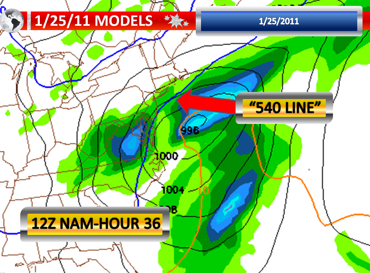
I noticed something very interesting today on the North American Model run from 12z which I think could be more credible than the newest run. This run showed the rain and snow line setting up along the Delaware River in South Jersey and along Interstate 195 in Central New Jersey. With our previous storm system, this is exactly where the rain and snow line stopped. Today when I was in Monmouth County, as soon as you travel north of Interstate 195, not even by a mile, all of a sudden you run into a fresh snow cover. My observer in Riverside also noted that she picked up more snow than in the rest of Burlington County. This also confirmed the radar imagery with the last storm showing that this is where line of difference set up shop. Also, similar to the previous snow, colder air would come in at the end of the storm changing any mix or rain back to wet snow. The only differences on this run from the previous storm are that the storm would last longer, contain more moisture, and be stronger.

The 12z GFS has the storm further offshore, giving New Jersey precipitation, and not much west of the Delaware River. This would give the coastal sections the most precipitation. This track would be colder with snow inland and rain along the coastal counties with mixing in-between. To repeat, the 18z GFS shows no storm at all.

If we should see a storm track where the area of low pressure rides over our region, as the ECMWF suggests…we would see rain and the dividing line between rain and snow would push into Northwestern New Jersey. The EURO has been the only model of consistence. It is worth watching the model to see if it also trends offshore. We will not know until 1:00 a.m.

However, SHOULD WE see the storm track JUST offshore, I am thinking that the dividing line will set up along the Delaware River and along Interstate195. North of this area there could be heavy snow and sleet, along with freezing rain. It should be noted that no storm is exactly alike. I am also thinking that for the first part of the storm, just as in the previous storm, there will be a battle zone between County Route 537 in Burlington and Ocean Counties and the Atlantic City Expressway. This is the zone where cold air damming could make all the difference between rain and freezing rain. For Atlantic City and Cape May, these areas look to see a brief mix or no mix at all with a coastal hugger. Again, a further offshore track could mean mainly snow or no precipitation at all.

This storm has the potential to be loaded with moisture if it does strike, particularly with a close track. In fact even though you see the newest American models showing an out to sea solution, the precipitation associated with the system is quite impressive. This raises several concerns IF this is in fact the case. If the cold air damming holds on the onset…..just in those first few hours you could have several inches of snow or quite a bit of ice accretion before the change to liquid rain in some areas. Where it remains all snow in New Jersey, if it does at all, you would be talking about a substantial snow accumulation. Where it remains ice, you could be talking about a serious accretion of ice. Finally, where it rains, due to the wet ground, we could have some flooding concerns. The prospect that New Jersey could be divided into three sections by precipitation types is certainly interesting. Then again we have this brush of a storm idea which would mean just an average amount of liquid we would have to play with or really none at all.

Wind could be a factor as well if this storm is a coastal hugger or if it tracks over us. The track is critical in determining the wind speed and wind direction. This has consequences as far as the chance of coastal flooding. If it coincides with heavy snow or heavy ice…there could be some power outages. If there is heavy rain, the ground could be very soft and it would not take much more than a 40 mph gust to take down some shallow rooted trees. Areas that see strong winds and heavy snow may be looking at near blizzard conditions. The idea with this rambling and throwing out all these possibilities is to get you thinking about what may happen with each of these different scenarios’ that have been thrown out at us.

Model flip-flopping makes this a very difficult forecast. We are still 72 hours away from this event. It is also interesting that the new NAM model is showing this storm at our latitude late Wednesday, which would result in a further delay. This storm looked to be hitting us on Tuesday yesterday and this would have put us in the 48 hour period where we would have much better confidence. Now with this starting later on Wednesday, we may have to wait until Tuesday Morning before getting a much better idea.

Other notes: I am also a part-time forecaster for the site http://phillyweather.net . I will also be filling in for the site founder this week as he is going to be out of town on business. So check that site out as well. Brian, a founder of the site http://cnyweather.blogspot.com is also a colleague on that site and will be filling in as well. If you headed up to Oswego at any point in the future, be sure to check out his forecast for that area.

for updates as new information streams in.

Saturday, January 22, 2011

Late Night Model Runs on Winter Storm Threat


The North American Model is still out of range on the 00z run, but it will be in range on Sunday. Based on the latest run of the model, it would appear that the storm system would be taking an inland track on this run which would result in warmer air moving into the region changing over the precipitation to freezing rain or even plain rain. If this is the case, we would be looking at the potential for significant flooding or significant icing depending on where you live in New Jersey because the system will be loaded with moisture. The “540 line” retreats to the north and west in advance of the precipitation arriving in the area and you need to be north of that line if you want snow.

The Global Forecast Model has shifted the track a bit further to the west tonight on the 00z run. The track on this run is still to our east, meaning we would be on the colder side of the storm. The “540 line” does retreat back to the north and west a bit, especially in Southern New Jersey. This means that this would be a mixture of snow, sleet, and freezing rain with a bit of plain rain along the coast.

A lot to watch on Sunday.

1/22/2011 Extended Forecast...Plus Latest on Storm Potential Tue./Wed.


I know everyone wants an update on the winter storm threat that looms, so let me talk about it first. Then I will get to the brutal cold. There continues to be a threat of a significant storm system on Tuesday into Wednesday. A trend has developed today, but there is no certainty that this trend will hold. Some of the more reliable modeling has taken the storm track and shifted it to our east. What I believe is happening is that the models are beginning to pick up on the fact that the colder air will be too strong of a force and this cold air will block the storm from cutting up directly at us. We just now have to be careful that the cold air and blocking pattern is not strong enough to avoid an event for our area all together. I still would like to see another two or three rounds of model data before I am confident that the wetter/icier vs. white solution will not take place. But it appears confidence is growing for a colder storm across Central and Southern New Jersey which would favor increased chances for frozen precipitation.

I want to clarify a rumor I have been hearing today about this storm. If you are on the colder side with a storm passing to your east…you will automatically have snow. This is FALSE. In the Summer time, occasionally you have a coastal storm that passes us by. However, WE DO NOT see snow. When one says that we see the colder side, it is implied that the air flow will be from a direction that typically draws in or maintains a cooler regime. If the storm tracks to our west, we would be on the warmer side because usually the air flow will be from a direction that typically brings in warmer air. To be more specific, an eastern storm track brings in northerly wind component of some sort and a western storm track brings in a southerly wind component of some sort. The air around an area of low pressure is counterclockwise in the United States.

The 12z GFS and 18z model shows very little in precipitation with the storm tracking well to our east as it is being blocked by a very cold, arctic air mass. Prior runs showed a significant snowstorm with some mixing involved along the coastal counties.
The 12z ECMWF or European model shows a good size snowfall for our region, but not the most dramatic of storms we have seen in the past year. It too gives an idea that there will be some sleet and freezing rain down at the immediate coastline and perhaps in the Southeastern NJ areas.

The 12z and 18z NAM continues to show a strong low pressure area developing in the Southeastern United States. This low then moves northeast on the model. However, the model only goes out to hour 84 and therefore I cannot get a good feel as to where the model brings that low center. The NAM I feel has done a fairly good job this winter and so tomorrow I will take this model and the output somewhat seriously.

The energy is just beginning to enter a region of North America where there is much better instrumentation and sampling of the atmosphere. This will be critical in determining where exactly this storm will track. Equally as important will be the clipper passing by tonight that will set the stage for the exact placement of an area of high pressure to our north. Until we verify where this exactly sets up, there will be lower confidence in the forecast. This will be the key in determining how much cold air is locked into place and where the blocking sets up.

At the present time, I will discount the one model indicating a complete miss. This storm has the potential to bring three to six inches of rain, 12 inches or more of snow, or serious ice accumulations. It just depends how all the cards fall into place. It is worth repeating that although I am dismissing it for the moment; we just now have to be careful that the cold air and blocking pattern is not strong enough to avoid an event for our area all together.

Moving on from the subject of a storm potential for a moment, I hope you stayed indoors as much as possible today. It was downright frigid outside. Much of the day was spent with temperatures in the teens. The sunshine hid behind several cloud layers this afternoon. Without the sunshine, it felt even chillier! The brisk wind today gave us single digit wind chills during the day which made it feel all the more brutal outside! The European Model last weekend was dead on with the idea of an arctic attack striking us this weekend.

A clipper system will pass to our north overnight into Sunday Morning. It will bring clouds to our region. Therefore, temperatures will not drop like a rock tonight. The wind will relax quite a bit tonight and pick up very briefly on Sunday as the clipper slides a cold front throughout area. Since the air mass is very cold, single digits to lower teens are still likely for low temperatures.

On Sunday, there will be morning clouds followed by afternoon clearing. The morning clouds and very cold start in this type of air mass point to another day with temperatures well below freezing. Highs in the middle twenties seem reasonable. There is a slight chance of a snow squall or a snow flurry with the passing front, although most of the high resolution models point to a dry passage. I think the better chances of this happening will be in the northwestern portions of New Jersey. Sometimes these snow showers do make it down to about Route 1 or Route 130.

On Sunday Night into Early Monday Morning is when I suspect we will see the coldest minimum temperatures. Skies will be clear, there is some snow cover around (especially into North-Central New Jersey), and we will have calm winds. The heart of an arctic attack will also be over us. These factors point to single digit lows being possible in the cities of New Brunswick and Camden with lower single digits elsewhere. Some of our coldest suburbs could definitely go below the zero degree mark for a time. This includes Somerville, Chatsworth, Lakehurst, and Millville. This cold is the kind that can cause serious water main breaks in the urbanized areas of New Jersey. Everyone will also be using their heaters and this is typically when we see some fires break out in homes. The fires that do break out will be difficult to contain as the extremely cold temperatures will cause ice to form around the scene very quickly when firefighters use water to douse the flames. A range of -5 to 5 seems reasonable. Being that I am thinking the wind will be calm, wind chills should not be a factor. However, if you get just a slight breeze it could be pushing wind chill advisory criteria.

The latest information is suggesting that Monday could actually be colder than Saturday and Sunday! I think temperatures will have an extremely difficult time recovering from the overnight low temperatures. The core of the arctic attack may not retreat until later in the day. I am going to forecast a high of 19 degrees for Monday. Yes, it may make it to 20 degrees. But the idea here is that outside of the urban heat islands….teens will most likely be the outcome.

One more note: there could be a lull Tuesday and Wednesday at some point. It is too early to nail down whether this will be the case.

Other notes: I am also a part-time forecaster for the site http://phillyweather.net . Saturday is my day of responsibility for this site, so a more regionalized forecast for the Delaware and Lehigh Valley can be found there today and every single day. I will also be filling in for the site founder next week as he is going to be out of town on business. So check that site out as well. Brian, a founder of the site http://cnyweather.blogspot.com is also a colleague on that site and will be filling in as well. If you headed up to Oswego at any point in the future, be sure to check out his forecast for that area.

I will remain committed to tracking this potential winter storm throughout the remainder of the weekend and next week.