In Hunterdon County (New Jersey), a funnel cloud was reported in Alexandria Township. In Morris County, a funnel cloud was reported in Chester Township. In Passaic County, an impressive three funnel clouds were spotted at one time in Wayne Township. There were trees and power lines knocked down in Hunterdon and Morris Counties, including in Alexandria Township. WNBC in New York is reporting possible tornado damage in Denville Township, but the National Weather Service reports that they believe it was thunderstorm wind damage. Jersey Central Power and Light’s online outage map did show several thousand in that area without power at one point in these areas. Of course, we will keep you updated if there is a report of an actual tornado touchdown in this area.
Anthony Gigi told NJ.Com the following: "The reports that we are getting are more consistent with a severe thunderstorm rather than a tornado. We’re not seeing hundreds of trees down or roofs ripped off of homes," Gigi said.
The storm prompted tornado warnings for several North-Central New Jersey and Northeastern New Jersey counties due to strong rotation being detected on doppler radar.

Thursday, April 28, 2011
Breaking News: Tornado Warning
TORNADO WARNING
NJC019-041-PAC017-095-281530-
/O.NEW.KPHI.TO.W.0001.110428T1458Z-110428T1530Z/
BULLETIN - EAS ACTIVATION REQUESTED
TORNADO WARNING
NATIONAL WEATHER SERVICE MOUNT HOLLY NJ
1058 AM EDT THU APR 28 2011
THE NATIONAL WEATHER SERVICE IN MOUNT HOLLY NJ HAS ISSUED A
* TORNADO WARNING FOR...
SOUTH CENTRAL NORTHAMPTON COUNTY IN EASTERN PENNSYLVANIA...
NORTHWESTERN HUNTERDON COUNTY IN NORTHWEST NEW JERSEY...
SOUTHWESTERN WARREN COUNTY IN NORTHWEST NEW JERSEY... NORTH CENTRAL BUCKS COUNTY IN SOUTHEAST PENNSYLVANIA...
* UNTIL 1130 AM EDT
* AT 1057 AM EDT...NATIONAL WEATHER SERVICE DOPPLER RADAR INDICATED A
SEVERE THUNDERSTORM CAPABLE OF PRODUCING A TORNADO NEAR FERNDALE...
OR 9 MILES SOUTH OF EASTON...MOVING NORTHEAST AT 50 MPH.
* THE TORNADO WILL BE NEAR...
HAMPTON...GLEN GARDNER...HIGH BRIDGE AND WASHINGTON BY 1105 AM
EDT...
PRECAUTIONARY/PREPAREDNESS ACTIONS...
IN ADDITION TO THE TORNADO...THIS STORM IS CAPABLE OF PRODUCING
QUARTER SIZE HAIL AND DAMAGING STRAIGHT LINE WINDS.
THE SAFEST PLACE TO BE DURING A TORNADO IS IN A BASEMENT. GET UNDER A
WORKBENCH OR OTHER PIECE OF STURDY FURNITURE. IF NO BASEMENT IS
AVAILABLE...SEEK SHELTER ON THE LOWEST FLOOR OF THE BUILDING IN AN
INTERIOR HALLWAY OR ROOM SUCH AS A CLOSET. USE BLANKETS OR PILLOWS TO
COVER YOUR BODY AND ALWAYS STAY AWAY FROM WINDOWS.
IF IN MOBILE HOMES OR VEHICLES...EVACUATE THEM AND GET INSIDE A
SUBSTANTIAL SHELTER. IF NO SHELTER IS AVAILABLE...LIE FLAT IN THE
NEAREST DITCH OR OTHER LOW SPOT AND COVER YOUR HEAD WITH YOUR HANDS.
A SEVERE THUNDERSTORM WATCH REMAINS IN EFFECT UNTIL 400 PM EDT
THURSDAY AFTERNOON FOR NORTHERN DELAWARE AND NORTHEASTERN MARYLAND
AND NEW JERSEY AND EASTERN PENNSYLVANIA.
&&
LAT...LON 4078 7500 4065 7485 4050 7520 4058 7528
TIME...MOT...LOC 1458Z 230DEG 83KT 4060 7512
$$
GORSE
Dangerous Severe Weather Threat Today: Tornado Risk


I hate to be so to the point, but this is a severe weather day for New Jersey. Severe thunderstorms are maintaining their intensity and will regain some of their strength now that the sunshine is up. The severe thunderstorms are presently across Central Maryland and Virginia into Central Pennsylvania. You want to monitor the storm cells to our southwest and those that pop-up ahead of the line.
The super cell composite and tornado composite is off the charts for New Jersey standards. Confidence of at least one tornado in the Philadelphia and New York City metropolitan areas is high for me. I think there is a decent chance of 2 or more tornadoes as well within 25 or 50 miles of a point. The primary risk is damaging wind gusts, but tornadoes are possible along with large hail.
Throughout the morning and afternoon, please stay with NOAA Weather Radio for the latest weather information or a local media source. Take action if a tornado warning or severe thunderstorm warning is issued for the region. I encourage school officials and other public safety officials to think about taking action if a severe weather watch is issued. Some sunshine has been poking through the clouds in parts of New Jersey and this is just self-destructing.
Wednesday, April 27, 2011
Concern for Severe Wx Continues


Scattered thunderstorms are possible today across much of New Jersey. The North American Model indicates the highest chances for thunderstorms in Western New Jersey. While many areas will remain dry, where the thunderstorms develop could be problematic. The thunderstorms may contain heavy rainfall, strong wind gusts, and hail. The western fringes of New Jersey, especially Northwestern New Jersey, are under a slight risk of severe thunderstorms with the remainder of New Jersey in a “see text” risk of severe thunderstorms. This will constantly be readjusted throughout the afternoon by the Storm Prediction Center.
Confidence continues to increase that there will be a significant severe weather and heavy rainfall situation developing across New Jersey on Thursday. The computer modeling has been in agreement about a potential severe weather outbreak for our region since Saturday Night. This kind of consistency is rarely seen during severe weather season. It is also notable that the slight risk designation for all of New Jersey has been placed over our region as far as three days out. The Global Forecast System model seems to have a much better handle on the overall threat this time around and it is probably because the timing on the GFS seems more reasonable and is also more in line with the likely daytime heating before the arrival of the thunderstorms. The strong winds will be increasing aloft with the strengthening low over the Great Lakes driving the potent cold front eastward. With the wind fields strong aloft, heavy convection should be able to drag the strong winds to the surface in the form of downdrafts.
If the GFS is correct with its indication that at least a weak meso-frontal wave of low pressure develops along the front, the helicity values would increase and combine with the unusually strong unidirectional shear to form favorable conditions for isolated tornadoes. This storm system has been responsible for numerous tornado outbreaks this week and the history does strike me as interesting. However, several systems have been known to fizzle east of the Appalachian’s and thus this logic applied just by itself would fail most of the time if solely used. However, here in this situation, a combination of scientific factors makes it seem reasonable to allow for isolated tornadoes even here in New Jersey on Thursday. The sad truth is that there could be one tornado the entire day and yet if it impacts a populated area…it would be a much talked about and likely more serious scenario. I don’t think we will see a major tornado outbreak at this present time or strong, long-lived tornadoes. What is unfolding in the Tennessee Valley won’t happen here to that degree. But weak ones do kill and we can see some of the tomorrow. The strongest tornado ever to occur in New Jersey was a F3 tornado and therefore history would argue against it.
The severe weather threat we face tomorrow will be affected by the amount of daytime heating. Any ongoing thunderstorms moving ahead of the front could arrive as early as Thursday Morning, but some models are not showing this to be widespread during the night. However, this doesn’t necessarily mean we would escape the cloud debris from the leftover storm cells. This will have to be taken into account early in the morning on Thursday when we know for sure. But, given the dynamics in place, I still am confidence of a nasty thunderstorm situation transpiring without the best sunshine. Given the situation, should we sunshine on Thursday, it would only be self-destructive.
A flash flood watch was issued for Northeastern New Jersey with a flood watch issued for the Raritan River Valley. This is the area that has been the most vulnerable for weeks as repeated heavy rain events and major crests have centered on and around this area. The models are suggesting an inch to two inches of rain tomorrow, much of which is occurring in less than 8 hours. Therefore, flooding and flash flooding is possible. Flash flood guidance suggests 1 to 2 inches is needed for flash flooding in much of North and Central New Jersey. 3 to 4 inches of rain is needed in Southern New Jersey. The front will slow down quite a bit on Thursday and therefore thunderstorms could train over the same areas allowing for localized pockets of excessive rain, perhaps in excess of the 1 to 2 inch range that is forecasted for a widespread geographical area.
Tuesday, April 26, 2011
Active 48 Hours

It will be a very busy few days as several rounds of thunderstorms will be affecting the region. The first is currently in progress and will skirt Northwestern New Jersey late tonight with a short term damaging wind potential.
On Wednesday, additional thunderstorm development will likely initiate well ahead of the cold front to our west that will be responsible for incredible tornado outbreaks and damaging wind events in the Ohio River Valley southward through the Gulf Coast. The thunderstorms will likely be scattered in nature on Wednesday. Parts of New Jersey have been placed under a slight risk for severe thunderstorms by the Storm Prediction Center.
On Thursday, a more organized severe weather threat is expected as the cold front actually moves through the region. We are currently under a slight risk for severe thunderstorms. Damaging winds, large hail, and even isolated tornadoes are quite likely if the thunderstorms develop. Timing means everything and the models are diverging on when the storms roll through.
Severe Weather Outbreak Likely on Thursday...May Include Tornado Potential


It is early on Tuesday Morning. I have been up very early into the morning analiyzing some of the latest computer model guidance regarding a potential dangerous outbreak of severe thunderstorms on Thursday. On paper, I haven’t seen such a good possibility of severe thunderstorms since the outbreak last summer which brought a 76 MPH wind gust to Philadelphia International Airport.
Damaging wind gusts on Thursday look like a very good possibility at this present time. However, the computer model guidance also is suggesting a lot of key players that would also make tornadoes a possibility. This is three days out and a lot could change. However, if the current projections are handling the event correctly, it appears there will be a lot of shear in place that would allow for the development of tornadoes, in addition to damaging winds and large hail. Not everyone will see damaging wind gusts or a tornado as is usually the case. But there could very well be more reports than usual of these elements.
The North American Model is currently the most robust with the potential of severe weather and that is because the time frame of this activity has it arriving in the late afternoon and early evening hours when daytime heating is maximized. The Global Forecast System model is earlier with the arrival of the thunderstorms, around early afternoon. However, even this model is showing some pretty nasty thunderstorm development.
In addition to the severe weather, heavy rainfall and frequent cloud to ground lightning is possible. The warm and humid conditions will make for ripe conditions for thunderstorm development, especially the more sunshine we observed prior to the thunderstorms on Thursday.
We may have scattered thunderstorms on Wednesday which will be the result of tropical moisture being pulled into the region from a disturbance that will be over the Atlantic Ocean. The tropical disturbance could enhance some thunderstorms in parts of the region on Wednesday afternoon and while scattered, heavy rainfall perhaps to excessive amounts locally will be possible. Should we see decent heating prior to that time, some of the thunderstorms may even become severe.
Monday, April 25, 2011
Isolated Thunderstorms Later Today

A warm front is currently lifting through North-Central New Jersey, with plenty of sunshine to the south of the boundary.
Despite increasing instability with daytime heating---I don't see too many things out there to trigger thunderstorms here in New Jersey. I think the primary threat for thunderstorms will be in Pennsylvania today. However, a sea breeze front or bay breeze front could initiate an isolated t-storm. With the warm front lifting northward, a hidden boundary riding along it may also pose a risk for an isolated shower or thunderstorm.
The 06z GFS was a bit more robust with the thunderstorm chances for today, compared to the 12z NAM. Any thunderstorm that does form, could potentially produce strong gusty winds, hail, and dangerous lightning. Otherwise it will be a sunny day with warm and humid conditions. Some southern sections may inch towards the 90 degree mark.
Sunday, April 24, 2011
Lightning Storms cause some power issues
Thunderstorms developed into a line this evening that sagged south into Southern New Jersey. While no severe weather was reported with this line, the thunderstorms packed quite a bit of intense lightning leaving several thounsand in the dark in Southern New Jersey...especially around the Atlantic Cityt Metro where reports of more than 3,000 without power for a time were received.
However, between 12:30 a.m. and 2:45 a.m., another batch of thunderstorm will move in from Eastern Maryland and Delaware. This cluster has been producing very intense lightning all evening and should continue to do so as it moves into South Jersey. Therefore....additional outages related to the dangerous and frequent cloud to ground lightning strikes will be likely.
However, between 12:30 a.m. and 2:45 a.m., another batch of thunderstorm will move in from Eastern Maryland and Delaware. This cluster has been producing very intense lightning all evening and should continue to do so as it moves into South Jersey. Therefore....additional outages related to the dangerous and frequent cloud to ground lightning strikes will be likely.
Severe Thunderstorm Watch Until 9 p.m. for Most of NJ
6:15 update:


A severe thunderstorm watch has been issued until 9:00 p.m. for the following counties:
In New Jersey: Atlantic, Burlington, Camden, Cape May, Cumberland, Gloucester, Salem, Ocean, Monmouth, Mercer, and Middlesex.
A severe thunderstorm watch means conditions are favorable for the development of severe weather including large hail and damaging winds. Severe thunderstorms can sometimes produce tornadoes with little or no warning.
The current surface analysis currently shows CAPE values of 1,000 j/g to 1,500 j/kg across much of Central and Southern New Jersey. Low-level lapse rates are around 8 c/km right now which is pretty steep. The lifted index values currently are in a range of -3 to -5. The supercell composite is suggesting values of 0.50 to 2 region wide. The significant hail composite is showing values of 0.50 to 1.50 across Southwestern New Jersey which the Derecho Composite showing values of 1 to 4.
What this all basically means is that there appears to be sufficient instability for thunderstorms to turn rapidly turn severe should there be any forcing mechanism to initiate them. What I think could do the trick is an area of thunderstorms that is beginning to redevelop over Maryland and Virginia. This could cause some very late afternoon and especially early evening scattered thunderstorms to form. These thunderstorms have the potential to form as line segments and supercells.
Most of the region has warmed well beyond the model guidance this afternoon with high temperatures so far in the 82 to 84 degree range. A localized sea breeze front may cool things down in portions of the coastal counties, but elsewhere it should remain quite warm and unstable until the sun begins to set this evening. The sea breeze front itself may serve as a focus for thunderstorm initiation if it begins to interact with the convection that should develop and transpire to our southwest.
Severe Thunderstorms Early This Evening Possible

The Storm Prediction Center has been and will continue to monitor New Jersey and SW for a possible weather watch issuance within the next hour or two for severe thunderstorms.
The current surface analysis currently shows CAPE values of 1,000 j/g to 1,500 j/kg across much of Central and Southern New Jersey. Low-level lapse rates are around 8 c/km right now which is pretty steep. The lifted index values currently are in a range of -3 to -5. The supercell composite is suggesting values of 0.50 to 2 region wide. The significant hail composite is showing values of 0.50 to 1.50 across Southwestern New Jersey which the Derecho Composite showing values of 1 to 4.
What this all basically means is that there appears to be sufficient instability for thunderstorms to turn rapidly turn severe should there be any forcing mechanism to initiate them. What I think could do the trick is an area of thunderstorms that is beginning to redevelop over Maryland and Virginia. This could cause some very late afternoon and especially early evening scattered thunderstorms to form. These thunderstorms have the potential to form as line segments and supercells.
Most of the region has warmed well beyond the model guidance this afternoon with high temperatures so far in the 82 to 84 degree range. A localized sea breeze front may cool things down in portions of the coastal counties, but elsewhere it should remain quite warm and unstable until the sun begins to set this evening. The sea breeze front itself may serve as a focus for thunderstorm initiation if it begins to interact with the convection that should develop and transpire to our southwest.
Slight Risk for Severe Thunderstorms Today

A slight risk of severe thunderstorms continues for today by the Storm Prediction Center. A cold front will put on the brakes as it approaches the region while we will be in the warm sector of the front. Waves of low pressure will move along the boundary causing areas of thunderstorms to develop today and move along and south of the boundary.
With sunshine expected after morning clouds and showers, the atmosphere should see instability rapidly increase. Steep lapse rates and sufficient shear will pose a risk for damaging wind gusts and large hail. There is a 2% chance of an isolated tornado due to the shear.
Saturday, April 23, 2011
A Few T-storms the Rest of Today, Slight Risk of Severe Wx on Sunday

The morning rain is now exiting the coastline. Overcast skies may eventually give way to mostly cloudy skies this afternoon, resulting in some peaks of sunshine. The sunshine would quickly destabilize the atmosphere and with some moisture left in place combined with good bulk shear, some widely scattered thunderstorms may develop, especially out of the current shower cluster exiting West Virginia. Even if it is cloudy, thunderstorms that initiate may move into the overcast areas. The Storm Prediction Center maintains a “see text” or 5% risk of severe weather for today. There is a 5% risk for damaging winds and a 5% risk for large hail. There is some thinning noted in Central Pennsylvania and Central Maryland before that next batch of organized showers and eventual thunderstorms moves our way from West Virginia and this will probably bring the greatest potential for pop-up showers and thunderstorms as there isn’t a whole lot of forcing out there. But even given this area on the radar…the cluster of showers and thunderstorms may affect areas mainly south of Trenton.
Several rounds of thunderstorms are a possibility on Sunday. While instability will be modest with expected cloud cover, enough of it will combine with bulk shear and more organized trigger mechanisms to warrant a probability of strong to severe thunderstorms. The Storm Prediction Center has placed the region under a slight risk of severe thunderstorms for Sunday, with a 15% probability of severe weather within 25 miles of a point.
Friday, April 22, 2011
More Soaking Rain and a T-Storm Late into Saturday

Tonight and especially Saturday Morning will be wet. Rain develops this evening from west to east. The rain will become heavy at times on Saturday Morning and move out of the region slowly on Saturday Afternoon. There should be some thunderstorms as well. 1 to 2 inches of rain seems to be reasonable at this point. Renewed flooding across the swollen rivers, creeks, and streams is possible given how well above normal they are running.
Much of North and Central New Jersey needs 1 to 2 inches of rain in six hours to begin to cause flash flooding. Southwestern New Jersey into Monmouth County needs about 2 to 3 inches to flooding with the remainder of the region needing amounts in excess of 3 inches for problems to begin. Much of this rain will come in 10-14 hours and this is worth watching...especially with thunderstorms are possiblilty as the North American Model from 12z suggests. While this event will be not nearly as intense as last weekend...things are just saturated out there from past few soakers.
To me, on the map, while the instability is not nearly as strong as the day we had the slight risk, enough it will be present that there could be a few strong to severe thunderstorms. As of early this morning, the Storm Prediction Center has placed the region under a "see text" risk for severe thunderstorms. I would say the chances are greater than the other day despite their lower probabilities at the moment.
Wednesday, April 20, 2011
Legit questions I proposed are answered
NOT one thunderstorm. As I stated all day convergence was weak. Could a storm pop between now and midnight? Sure...but the chances are below twenty percent.NAM did it again!
Watching Skies to the West

Thunderstorms have begun to develop...although very scattered and disorganized so far...in Central Pennsylvania. With strong instability in place, Central and Eastern Pennsylvania have been placed under a severe thunderstorm watch as that instability can cause a t-storm or two to organize to severe limits once a thunderstorm initiates. "Can" is the key word as forcing is weak. But with a "chance", the watch has been posted for the areas out to our west.
The NAM from 18z just in continues to show that these storms remain disorganized due to a lack of strong convergence and that they diminish greatly by the time they arrive in New Jersey as night begins to approach. The instability may cause these storms to survive a bit more than the models indicate...but as I have been indicating...the threat for thunderstorms will be isolated especially with the instability to decrease when they arrive between 8 and 9 or even later.
The slight risk area has also been reduced and cut down to include less of NJ.
Sunshine to Increase from South to North, T-Storm Risk Remains


All of New Jersey remains under a slight risk for severe thunderstorms this afternoon and this evening by the Storm Prediction Center.
The risk for damaging winds is the primary risk, although the hail parameter guidance I use does suggest the potential for marginally severe hail.
We see very good sunshine breaking our within the warm sector in Southern New Jersey and I suspect this will lift northward throughout the afternoon, although some cloudiness from the west may tend to make things partly sunny when the sun breaks out for the remainder of Central and Southern New Jersey. The guidance continues to suggest a 20-30 degree temperature rise within a couple of hours which would drastically increase the instability needed for strong to severe thunderstorm initiation.
However, despite the given instability, there are STILL legitimate questions about whether there will be really a breakout of severe thunderstorms. Yes, we have a cold front which will act as a triggering mechanism to initiate thunderstorms. But the North American model and Global Forecast System model show weak convergence and lacks well organized and widespread thunderstorm initiation. In fact, the 12z NAM agrees with the previous two runs of the model and shows 0.00” of measurable precipitation in just about the entire New Jersey area.
So, this leads me to the forecast for the event. Thunderstorms will be isolated to scattered in nature. Due to the instability, where they develop, they could quickly become severe with the potential for damaging winds and possible hail. The higher resolution modeling is a bit more robust with the development of thunderstorms for this afternoon across our region...but even these models have trended towards scattered development. At this present time, I am leaning with the modeling indicating less explosive and widespread development. This does not mean we will not have some pretty significant events with notable damage, it just means some areas could be bone dry and cloudy while others are getting hammered just 20 miles from where you reside.
Tuesday, April 19, 2011
Slight Risk for Severe T-Storm Wednesday, But Will They Form?

For Wednesday, the Storm Prediction Center has placed our entire region under a slight risk for severe thunderstorms. In fact, the Storm Prediction Center has a high-end slight risk probability with a 30% chance for severe weather to occur within 25 miles of a point. Certainly the instability will be there tomorrow. Sunshine should develop by mid-morning and temperatures will quickly push well into the seventies as we will be in the warm sector of a warm front that will be lifting northward early this morning. Some of the more robust guidance even indicates some lower eighties across South Jersey. This will lead to CAPE values of 1,000 to 2,000 j/kg. The lifted index also may be at least -3, if not higher.
However, despite the given instability, there are legitimate questions about whether there will be really a breakout of severe thunderstorms. Yes, we have a cold front which will act as a triggering mechanism to initiate thunderstorms. But the North American model and Global Forecast System model show weak convergence and lacks well organized and widespread thunderstorm initiation. In fact, the 00z NAM shows 0.00” of measurable precipitation in just about the entire New Jersey area.
So, this leads me to the forecast for the event. Thunderstorms will be isolated to scattered in nature. Due to the instability, where they develop, they could quickly become severe with the potential for damaging winds. The higher resolution modeling is a bit more robust with the development of thunderstorms for tomorrow afternoon across our region. At this present time, I am leaning with the modeling indicating less explosive and widespread development. This does not mean we will not have some pretty significant events with notable damage, it just means some areas could be bone dry and cloudy while others are getting hammered just 20 miles from where you reside.
Showers and T-Storms Today

Frequent periods of showers and thunderstorms will affect the region today. Showers with a few thunderstorms are already moving in from the west along our nearly stationary cold front... which will eventually become a warm front and lift northward.
There will be quite a contrast from north to south today as the front will set up a dividing line. With the eventual warm front close to the warm sector and these waves riding along them, some strong to severe thunderstorms, isolated in nature, have the chance to form immediately south of the front while areas along and north of it will just see general showers and thunderstorms. 0.25" to 0.50"+ of rain appears likely still for the region with some localized higher amounts in thunderstorms.
Tonight I will discuss the potential for severe thunderstorms on Wednesday. The Storm Prediction Center has placed our area under a slight risk for severe thunderstorms on Wednesday.
Showers and Thunderstorms Tuesday & Wednesday

A cold front will meander around the region on Tuesday and then go into reverse as a warm front. During the transition process, a few waves of low pressure will be riding along the front providing plenty of clouds with showers and thunderstorms. Southern areas could be quite warmer than northern areas with it very dependent on which side of the front you reside on. This front may also allow for some severe convection on in the warmer sector as the waves ride along the frontal boundary.
On Wednesday, a cold front will come into the region. The models are not all that robust with the afternoon and evening t-storm potential, but with the region potentially all in the warm sector and an approaching trigger...some severe thunderstorms are possible...even if not widespread.
With many waterways near flood stage and running high, 0.50" inches of rain may pose some problems and certainly any heavier thunderstorms would be of great concern.
Sunday, April 17, 2011
Isolated Gusty T-Storms North Into This Evening Possible

The Storm Prediction Center has placed the northern half of New Jersey, including portions of North-Central New Jersey under a "see text" risk for severe thunderstorms and all of North/Central New Jersey in a general risk for thunderstorms.
A disturbance will take advantage of steep lapse rates to develop some showers and potentially a few isolated thunderstorms. I already see some showers developing downwind of the Great Lakes...moving on eastward. If they survive...they would arrive late this afternoon into early this evening...before losing daytime heating support. With stronger winds aloft (some observed already by good mixing with surface gusts to 40 MPH)...any t-storm may be able to tap into this a cause some marginally severe gusts.
At this time, I am keeping the threat isolated. CAPE values look very limited at this point and may develop slightly by 4 p.m. to coincide with the arrival of the disturbance.
Flooding:
Yesterday's rain really did a number on the region and this storm really lived up to the potential I had been forecasting. Major flooding once again is ongoing in Northern New Jersey with moderate flooding in portions of Central New Jersey. The windy conditions today are also combining with the wet ground and I have had a few reports of power outages.
Coastal Flooding:
Still a threat of minor to moderate tidal flooding for the next few high tide cycles along the tidal portions of the Delaware River in Southern New Jersey.
Saturday, April 16, 2011
Major Storm: Numerous Flood Warnings, Near-Record Flooding Near Philadelphia
Just after 10:50 p.m., the National Weather Service issued a special weather statement regarding near-record, major tidal flooding in addition to the coastal flood warning...
At Philadelphia, high tide occurs at 1:12 a.m. with a forecast high-tide level 10.5 feet above mean lower low water. The last time the tide level reached 10 feet at Philadelphia was on December 11, 1992.
The record level is 10.8 feet which occured on November 25, 1950. The National Weather Service expects severe flooding according to the statement and is advising all residents along the tidal areas to pay close attention to rising waters.
At this hour, nearly every county in our coverage area has been placed under a flood warning due to the excessive rainfall. Flooding is especially dangerous at night...turn around and don't drown.
Tornado Watch for Southwestern New Jersey Thus Far

Thunderstorm Wind Gusts to 70 MPH, Isolated Tornadoes, and Hail to 0.50” in diameter are possible in the watch area.
A tornado watch means conditions are favorable for the development of tornadoes, damaging winds, and or large hail.
Strong pressure falls are becoming clearly visible over Eastern Pennsylvania and Western New Jersey. I wouldn’t be surprised to see this shift northeastward throughout the evening. Without sunshine today, instability is modest at best. However, the jet setting up over the region and heavy thunderstorms will move in from the west and drag the strong winds to the surface with an increased risk for damaging wind gusts. In addition, vertical shear is quite impressive and the strongest thunderstorms may cause some spin-ups which may result in isolated tornado development in our region. Numerous severe thunderstorm warnings and tornado warnings have occurred to our south and west.
Very Windy and Wet This Evening and Tonight

Major storm headed towards the region this evening into tonight.
All of North and most of Central New Jersey is now under a flood watch. The NAM has widespread purple coloring indicating a quick 1.50 to 1.75 inches of rain in less than six hours during the time frame of convection which I suspect may lead to some localized flash flooding. Total rainfall of 1.75 to 2.50 inches looks to be a good bet for much of the region. Bucks, Montgomery, Eastern Berks, and Eastern Lehigh Counties into North-Central New Jersey need 1 to 2 inches in less than 6 hours for flash flooding to begin. Elsewhere in Pennsylvania…2 to 3 inches of rain would be needed for flash flooding to begin. In Southern New Jersey, rainfall amounts of 3 to 4 inches would be needed for flash flooding to begin and the sandier soil will make this area less vulnerable to flooding. If the NAM is correct, the heaviest rain would be right over the Delaware River and Interstate 95 corridor.

We also may be dealing with thunderstorms that could contain damaging wind gusts. Right now, the Storm Prediction Center has the slight risk for severe thunderstorms for portions of Southern New Jersey. I think it is possible that they will extend the risk area further northward in later outlooks. The North American Model and some of the high resolution models show clearly that a line of convection… pushing from west to east between 8:00 p.m. and 11:00 p.m. …will impact the region. Basically, a low or meso-low will develop a cold front pushing towards our region. The low will energize the front. Moisture will be streaming in from the fetch off the Atlantic and combine with the Gulf Moisture that is open for business. All of this suggests a super soaking and a good feed into a line of convection. The National Weather Service is concerned significant wind damage may occur east of this line in New Jersey and I couldn't agree with them more.
We also will be dealing with wind issues that are non-convective related. We have had some decent soakings and this will be another one. The ground will be wet enough to be supportive of an increased risk for trees to become uprooted in strong winds. Unfortunately, it looks like the jet intensifies by mid-evening during the timing of the heavy rain which could transfer the momentum down to the surface. Non-thunderstorm wind gusts of 40 to 50 MPH appear likely, perhaps higher than 50 MPH along the coastline. The National Weather Service has issued a wind advisory which implies sustained winds of 31 to 39 MPH or frequent wind gusts of 46 to 57 MPH are imminent or occurring. This is in effect from noon today until midnight tonight. The gradient looks tight enough that even when it is not raining...gusts of around 45 MPH will occur.
The strong onshore winds will also pose a risk for widespread minor coastal flooding, with scattered areas of moderate coastal flooding. A coastal flood warning has been issued for the tidal areas of the Delaware River and the entire New Jersey/Delaware Atlantic coastline.
* AT SANDY HOOK... NEW JERSEY (RARITAN BAY)... HIGH TIDE OCCURS
AT 720 PM... WITH A FORECAST TIDE LEVEL OF 7.5 TO 8.0 FEET
ABOVE MEAN LOWER LOW WATER.
* AT SEASIDE HEIGHTS... NEW JERSEY (OCEANFRONT)... HIGH TIDE
OCCURS AT 650 PM... WITH A FORECAST TIDE LEVEL NEAR 7.0 FEET
ABOVE MEAN LOWER LOW WATER.
* AT ATLANTIC CITY... NEW JERSEY (OCEANFRONT)... HIGH TIDE
OCCURS AT 657 PM... WITH A FORECAST TIDE LEVEL NEAR 7.0 FEET
ABOVE MEAN LOWER LOW WATER.
* AT CAPE MAY... NEW JERSEY (OCEANFRONT)... HIGH TIDE OCCURS AT
731 PM... WITH A FORECAST TIDE LEVEL OF 7.5 TO 8.0 FEET ABOVE
MEAN LOWER LOW WATER.
* AT BREAKWATER HARBOR... DELAWARE (DELAWARE BAY)... HIGH TIDE
OCCURS AT 809 PM... WITH A FORECAST TIDE LEVEL NEAR 7.0 FEET
ABOVE MEAN LOWER LOW WATER.
* AT REEDY POINT... DELAWARE (DELAWARE BAY)... HIGH TIDE OCCURS
AT 1041 PM... WITH A FORECAST TIDE LEVEL NEAR 8.5 FEET ABOVE
MEAN LOWER LOW WATER.
* AT PHILADELPHIA... PENNSYLVANIA (DELAWARE RIVER)... HIGH TIDE
OCCURS AT 112 AM SUNDAY... WITH A FORECAST TIDE LEVEL OF 9.0 TO
9.5 FEET ABOVE MEAN LOWER LOW WATER.
* HIGH TIDE OCCURS ON BACK BAYS AND TIDAL TRIBUTARIES LATER THAN
IT DOES ALONG THE OCEANFRONT.
* WAVES...WAVE HEIGHTS IN THE SURF ZONE ALONG THE OCEANFRONT MAY
BE IN THE 5 TO 8 FOOT RANGE.
Friday, April 15, 2011
Major Storm Saturday P.M....Widespread Issues

A major rain and wind event is anticipated for Saturday, especially Saturday Night into early on Sunday Morning. The system has the potential to create moderate coastal flooding, damaging winds, flash flooding/flooding, and coastal flooding.
A strengthening low pressure system is moving eastward towards the Great Lakes and in response a cold front will approach our region on Saturday. A significant wave of low pressure is anticipated to develop along the front which will energize it further. A fetch off the Atlantic Ocean and support from the Gulf of Mexico should be capable of causing a huge intensification in the rain over our area. Therefore, several inches of rain may occur and it could come in a 6 to 12 hour period, introducing the possibility of localized flash flooding. At this point, 1.50” to 3.50” of rain is looking like a very good possibility. If the rain doesn’t fall quick enough for flash flooding, these rainfall amounts could be very well capable of causing creeks and streams to rise to or over their banks. The North American Model is showing a good slug of purple on the 18z run, therefore I think the proposal of an excessive rainfall event is gaining more confidence.
There is an opportunity for some strong winds across the region. A strong jet will develop aloft and maximize over our region during the evening hours. Heavy rain will transport the strong winds down to the surface, but even without the rain…some of this wind will be capable of mixing to the surface with the tightening gradient. Thunderstorms, which are expected to occur any time after 6:00 p.m., will be even more capable of producing damaging wind gusts. Right now, a widespread severe weather outbreak is expected south of the region by the Storm Prediction Center where sunshine and warmer temperatures will allow for more destabilization of the atmosphere resulting in stronger downdrafts. However, we could definitely see at least scattered thunderstorms with damaging winds and I will continue to monitor the latest forecasts from the Storm Prediction Center. Right now, South Jersey is under a “see text” or a 5% risk for severe thunderstorms. The National Weather Service has issued a wind advisory meaning conditions are imminent or occurring in which sustained winds of 31 to 39 MPH or frequent gusts of 46 to 57 MPH from Noon to Midnight on Saturday. This product is issued for non-convective wind potential. I think we may even see some areas, especially along the coast where the east-southeast wind could be the strongest, upgraded to a high wind warning. I can see some gusts maximizing to around 65 MPH. Inland, widespread 40 to 55 MPH gusts are expected…possibly higher with thunderstorms.
Huge impact on the Delaware River and Atlantic Coasts with coastal flooding: Widespread minor tidal flooding likely, at least scattered moderate tidal flooding likely...maybe even some major tidal flooding if gusts can reach 55 or 60 MPH at the shore
Power Outages: Certainly possible just with the wind, not adding the wet ground and the soaking expected.
Temperatures tonight will drop into the lower forties in many locations and slowly work their way through into the fifties on Saturday. Temperatures will reach their highest point Saturday Evening. The storm pulls away early on Sunday morning, with rain leaving the coastline by daybreak. Sunshine should follow with breezy conditions. Temperatures will rise into the sixties during the afternoon.
Thursday, April 14, 2011
Significant Rain, Wind, and Thunderstorm Event Saturday P.M.

A strong onshore flow will develop on Friday afternoon and draw in Atlantic Moisture into the entire region. This is as high pressure builds to our north, allowing the wind to shift from the easterly direction. As Saturday transpires, a storm system will move in from the Plains and slowly lift northeast into the Great Lakes. The area of low pressure will drag a cold front through the region on Saturday Evening. A wave of low pressure is expected to organize on the front and, combined with that onshore flow, torrential rainfall appears likely.
In addition, there is the potential for another round of high winds from the east-southeast direction. Wind gusts between 40 and 60 MPH look like a strong bet at this point, although this will be nailed down in more detail as we approach the event. With the ground soakings of the past few weeks and more rain with this system...many trees could come down should there be high winds...and with developing leaves...the trees will even be more subceptible to falling. Thunderstorms are possible and these could feature the strongest gusts.
At this point, 1.50" to 3.00" of a soaking rain appear very likely. Some flooding is possible of creeks and streams. Some rivers could also flood if we approach the 3.00". Some of this will be thunderstorm dependent.
We will be also watching potential tornadic development to our south where the Storm Prediction Center already has a slight risk of severe weather to our south in the Day 3 outlook. The ocean flow can sometimes cause things to become stable and preclude such agressive t-storm development...but not always as such was the case the other day...
Wednesday, April 13, 2011
A Windy Storm Ending

A windy storm is slowly moving out.
NEW JERSEY
...ATLANTIC COUNTY...
ATLANTIC CITY 37 935 PM 4/12
...BURLINGTON COUNTY...
WRIGHTSTOWN 44 1033 PM 4/12
SOUTHAMPTON TWP 40 1043 PM 4/12
CHATSWORTH 39 1000 PM 4/12
MOUNT HOLLY AIRPORT 38 943 PM 4/12
...CAPE MAY COUNTY...
CAPE MAY 41 510 PM 4/12
OCEAN CITY 40 855 PM 4/12
...CUMBERLAND COUNTY...
MILLVILLE 33 458 PM 4/12
...MERCER COUNTY...
TRENTON 39 1052 PM 4/12
...MIDDLESEX COUNTY...
PERTH AMBOY 44 135 AM 4/13
...MONMOUTH COUNTY...
MONMOUTH BEACH 47 100 AM 4/13
SANDY HOOK 46 153 AM 4/13
KEANSBURG 44 100 AM 4/13
BELMAR 39 1135 PM 4/12
...OCEAN COUNTY...
SEASIDE HEIGHTS 49 1209 AM 4/13
BARNEGAT 47 1150 PM 4/12
BRICK TWP 47 1155 PM 4/12
TUCKERTON 44 945 PM 4/12
TOMS RIVER 33 1035 PM 4/12
The surface low is over Delaware and it will northward through this evening. Until then, fog and drizzle may exist.
An isolated t-storm may develop if any sunshine comes out before sunset...but a gradual return to sunshine may develop late this evening...late enough that it precludes any real instability to develop before the triggering mechanism departs.
Heavy rain is on the way for Saturday, and more t-storms.
Tuesday, April 12, 2011
Severe T-Storm Line

11:52 p.m. UPDATE:
We have been really getting hit tonight with some inclement weather, especially in Southern New Jersey. Numerous thunderstorms developed tonight. The first around rush hour produced frequent cloud to ground lightning and very heavy rainfall. The second, late tonight prompted severe thunderstorm warnings for quarter sized hail and damaging winds in excess of 60 MPH. Numerous reports of 30 to 45 MPH wind gusts were reported between 9:00 p.m. and 11:00 p.m. It is too early to confirm wind damage reports with the thunderstorm line, but power outages have been reported in the counties in which it moved over…but some of these outages could also be related to the strong, non-thunderstorm wind gusts.
The second line prompting the warnings is ongoing due to elevated warm air advection. The warm air is aloft as the marine flow is at the surface. The marine flow just hasn’t been able to win out tonight with the stable, oceanic air that typically keeps a cap on the development of thunderstorms. A strong jet aloft and a relatively cold pool of air has been responsible for the hail and wind.
East-northeast winds will be gusty and additional showers and thunderstorms are possible through the overnight.
So far Atlantic, Burlington, and Ocean Counties have been under a severe t-storm warning.
Watching a Very Strong T-Storm Moving Our Way
5:50 p.m. UPDATE: The T-storm is now in Burlington County...about to approach Mercer... Middlesex... and Monmouth Counties...the storm is moving right up Route 206 for the time being....


I am watching a very strong cluster of thunderstorms that developed in Delaware and has so far survived to Vineland and Millville...moving northeast rapidly at 55 to 60 MPH.
Frequent lightning, torrents of rain, hail, and wind gusts to 50 MPH are likely with this storm. Should this storm strengthen further...which it very well could...large hail and damaging winds are possible.
I'll be watching it to see how far NE it makes.
Wet and Windy Later

A cold front is dropping down south of the region this morning and the cold front will become stationary this afternoon. A wave of low pressure will develop along the front and numerous rain showers and thunderstorms will develop. Heavy rainfall is likely, especially tonight into Wednesday Morning. One to two inches of rain may fall over a widespread area. Thunderstorms could produce locally heavier amounts and some localized flash flooding is possible if the thunderstorms can train over the same areas later today.
The severe weather threat will be highest in Southern New Jersey. Extreme Southern New Jersey is under a 5%, “see text” risk from the Storm Prediction Center for hail. The cold pool aloft would provide for favorable conditions for hail, but you need stronger instability to produce thunderstorms that can develop and pull the hailstones to the surface. Since the greatest instability lies south, this is where you may have some isolated thunderstorms with hail. Winds aloft will be intensifying with the developing jet, so gusty showers in all areas are possible this evening into the night. East and Northeast winds will become quite gusty at times into tonight and the National Weather Service believes winds will gust to 40 MPH at times. They also mention the chance that for gusts to approach the criteria for a wind advisory (46 to 57 MPH), but they right now have not issued a wind headline due to uncertainty. The ground is fairly wet from a decent rain event on the 8th and previous March rains, and should the wind coincide with the heavy rain later…we may see a few power outage issues. T-storms will be limited, but gusty in all areas should one develop...but the oceanic flow will help bring more stability to the region.
The intensifying low will also pull in the air that is off the ocean which is much colder... and this will help drop temperatures...slowly for the next few hours and then a sharper drop into this evening. Temperatures could be in the low to mid 50's for the evening commute.
Northwestern New Jersey will see moderate to heavy rain this morning with a transition to the entire region late today.
Monday, April 11, 2011
Unsettled Tuesday and Wednesday

Thunderstorms flared up as expected in Eastern Pennsylvania, but quickly died down with nightfall. Temperatures are currently in the seventies, but will slowly drop. Highs on Tuesday will likely be reached within the first hour or two. Isolated showers and possibly some thunderstorms could pop-up into the morning commute.
The cold front essentially stalls right over the region on Tuesday and Wednesday. A strong wave of low pressure will develop along the cold front, energizing the front. Therefore, periods of showers and thunderstorms will be likely. Severe weather will be at a minimum as the clouds and frequent showers will hold down the temperatures and keep instability in check. There still is enough instability for at least some thunderstorms with heavy rainfall being the main threat, although an isolated gusty thunderstorm is not out of the question. The models are keying in on Tuesday Night into Early Wednesday Morning for the heaviest round of very heavy rain and heavy thunderstorms. Should peaks of sunshine occur tomorrow, then we may have an increased threat for stronger thunderstorms but at this point it will be a “nowcast” event.
Possible Severe Thunderstorms Tonight
5:00 p.m. UPDATE:
The cluster being eyed has really weakened...but within the next two hours it may develop or another line segment may form along the outflow boundary. The cluster weakened before entering the instablity axis the derecho composite illustrates clearly with 2-4 values. Tornado composite values have increased to 0.50-1.00 now with CAPE of 1,500 j/kg. CIN isn't good for development though...and I would like a closer forcing mechanism. We lose sunlight too in about 3 hours.

A cluster of thunderstorms has developed ahead of a cold front this afternoon near State College, Pennsylvania. This cluster is moving eastward and will move into New Jersey, should it survive, this evening and tonight.
The cluster of thunderstorms is likely going to become more organized as it moves eastward, until at least nightfall. Temperatures have soared into the middle eighties, as anticipated, with the exception of the immediate coastline. The record warmth has cause CAPE values to approach 1,000 j/kg and therefore there is sufficient instability to feed on for at least the first half of tonight before some of it could dissipate.
Damaging wind gusts will be the primary threat, but an isolated tornado threat is not out of the question, especially the closer to Pennsylvania. The tornado composite does suggest the opportunity for a tornado. I expect the cluster to also expand in size as it approaches more unstable air.
Sunday, April 10, 2011
Record Heat Monday...T-storms Monday Late into Tuesday
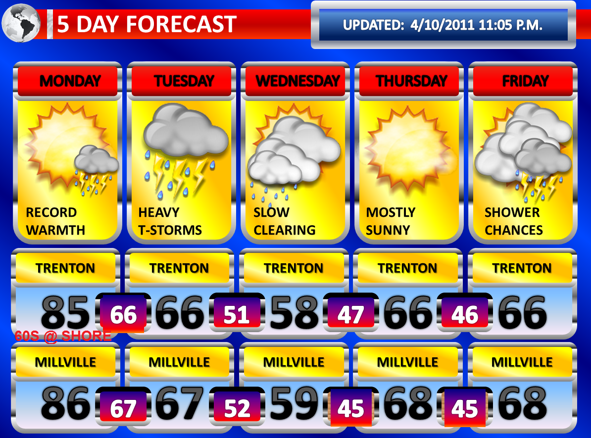
Record challenging high temperatures are anticipated for Monday, especially away from the coastline. Temperatures could approach 80 degrees or better once the sunshine comes out. I am still expecting a range of temperatures between 82 and 86 degrees. At the coast, the clearing will arrive last here and I also think the wind off the ocean will not be ideal for much better than 65-70 degrees.
On Monday Night, temperatures will be slow to cool. It is possible the readings drop a few degrees, before rising again ahead of a strong cold front arrive late Monday Night into Tuesday Morning. Thunderstorms may accompany the front. The models are not too robust with the convective activity and they are showing rapid dissipation with nightfall and as the thunderstorms enter into slightly more stable air near the Middle Atlantic Coastline. However, the nighttime temperatures of near seventy degrees will still allow for some instability to linger and at least some scattered severe thunderstorms may be possible.
The front may actually be more active on Tuesday as a wave of low pressure develops along the front as it slows down significantly over the region. There could be additional strong to severe thunderstorms on Tuesday, but there will be extensive cloudiness which could limit the potential. Heavy rainfall may be more of an impact on Tuesday. Several inches of rain could fall on Tuesday and may result in flash flooding. The first half of Wednesday could even be showery as the system takes time to gradually move out.
More showers and thunderstorms are possible on Friday with a warm front and on Saturday with a cold front.
Saturday, April 9, 2011
Extended Forecast for Sunday, April 10, 2011
As you may or may not know, I do the forecast for Phillyweather.net on Saturday Evening's. This is a plug for a very great site, rich in history about Eastern Pennsylvania, Delaware, and New Jersey for weather...in addition to excellent weather discussions! Check out phillyweather.net ....


Another severe weather outbreak from a potent feature has occurred today from Indiana down into South Carolina. This area has so far been getting hammered this past spring by severe thunderstorms and it appears that at least for the time being, this has developed into a weather pattern. Another outbreak of severe weather, potentially large, will develop in the northern half of the Midwest and this will slide east.
A warm front is moving northward and will arrive on Sunday Night. Ahead of the warm front, mostly cloudy skies and potential showers may develop. There could even be a few isolated thunderstorms on Sunday ahead of the front. All of this will slide to the north and east by early on Monday Morning.
The entire region should see skies clear on early Monday Morning, with northern sections observing the clearing line last. The sunshine will come out and the region will be entrenched well into a warm sector. Southerly winds, gusty at times, will pump in very warm air. Temperatures will likely range between 82 and 86 degrees across most of the region, with cooler readings in the Poconos. Some of our loyal site readers have done some research and have raised the prospect that we may squeeze out 90 degrees. At this point, I don’t believe it will be too widespread, but I will raise the maximum temperature to 86 degrees in Philadelphia. For Philadelphia International Airport, this could be a tricky scenario as a breeze off of the Delaware River could have a localized affect at the airport.
On Monday Night into very early on Tuesday Morning, a round of showers and thunderstorms is expected with a cold front. The cold front will likely arrive earlier in Central and Western Pennsylvania and this is where I anticipate a more widespread outbreak of severe thunderstorms. However, some instability will still be around in our region when the front arrives due to the near or actual record breaking temperature readings on Monday. Therefore, scattered severe thunderstorms are a possibility. It is still a little too early to speculate on the specific types of severe weather the region will see. Both the NAM and GFS really loose the convection at nightfall in our region.
Friday, April 8, 2011
Friday's Rain Givesway to Warm Times Ahead

A wave of low pressure continues to ride along a stalled frontal boundary. This system is bringing rain to our entire area. South of Interstate 195, the rain may be heavy at times. The NAM is indicating some colder air developing aloft this evening and the heavier bursts of rain may contain some sleet pellets or wet snowflakes. The rain will taper off to drizzle early on Saturday Morning before gradual clearing takes place.
There is a change in the forecast for Sunday. The modeling has delayed the warm front arrival until Sunday Night. This means Sunday will be cooler than previously forecast. It also means that Sunday Morning will be dry and now we are looking for some isolated showers or thunderstorms Sunday Evening into early on Monday Morning.
At this point, the warm front should clear Monday Morning and I am still expecting a very warm day with highs in the middle eighties in much of Central and Southern New Jersey. Should the warm front fail to clear the region, a few degrees could be shaved off the temperatures predicted.
Showers and thunderstorms will arrive Monday Evening and Monday Night, perhaps lingering into early Tuesday Morning. The exact timing will make a difference with the potential for severe thunderstorms. At this point, if they occur during nightfall, the likelihood of severe weather will decrease some. However, instability will not totally wane this quickly and some scattered severe thunderstorms are probable. The timing of the thunderstorms could move up and this may have an adverse effect on the high temperatures and severity of the storms.
Thursday, April 7, 2011
Record Warmth Expected on Monday---T-Storms Monday Night

Not much change from the previous forecast two days ago with the overall expectations of the weather features. A stalled frontal boundary will allow a wave of low pressure to ride along it on Friday. A cool, easterly flow will make for a miserable day. It will feel damp and cool with an east-northeast breeze. Rain should build in and if it is not raining, it will likely be drizzling.
On early Sunday Morning, a warm front will lift through the region. The warm front could be preceded by isolated showers and thunderstorms. The showers and thunderstorms along with clouds will likely clear the region by mid-morning and sun will appear from south to north. As the front clears, the sunshine will combine with a strong southerly flow to cause temperatures to accelerate. Middle seventies look very reasonable and I could see some locations in Southern New Jersey reach near 80 degrees.
On Monday, temperatures will soar into the middle eighties and we could potentially see some upper eighties. A cold front will approach at night into early Tuesday Morning. This timing, if it does not move up, will allow us to once again miss the brunt of what could potentially be another outbreak of severe weather to our west. However, with such warm temperatures expected even at night and at least some instability lingering from the intense April heat, I expect at least some scattered severe thunderstorms. The cold front and thunderstorms will bust the record warmth. However, temperatures will be in the sixties and seventies afterwards.
Tuesday, April 5, 2011
Severe Wx Outbreak for U.S. One of the Biggest Ever

On this blog, I discussed the potential for a major severe weather outbreak, particularly south and west of here for several days. Now that the dust has settled, more than 1,200 preliminary reports of severe weather, according to the Storm Prediction Center, occurred. This is one of the highest numbers ever recorded for a single day. There were 32 reports of tornadoes, 1312 reports of wind damage, and 89 reports of large hail. Today, there were 50 reports of wind damage and there was 1 report of large hail.
An unsettled pattern is expected for our region. A cold front will swing through the region tomorrow night. The front is expected to stall to our south and allow numerous disturbances to ride along it. The result will be periods of showers. On Friday, a more organized area of rain and possibly a few rumbles of thunder may occur. Then a warm front lifts northward Saturday Evening into early on Sunday Morning. This will allow for showers and thunderstorms during that period. Then Sunday will be mostly sunny and a very similar day to Wednesday of this week with increasing sunshine and very warm readings. At this point, with the distance we have, I won’t go with lower eighties…but Sunday could very well end up being that warm.
Sometime during the time frame of Monday, a strong cold front is yet again forecast to move into the region. The timing will make all the difference. However, somewhere along the eastern regions of the United States is expected to see another outbreak of severe weather. It is day six in the forecast period and therefore more details will be forthcoming tomorrow.
Today's wind gusts:
NEW JERSEY
...ATLANTIC COUNTY...
ATLANTIC CITY AIRPOR 40 1159 AM 4/05
...BURLINGTON COUNTY...
RED LION 44 1030 AM 4/05
...CAPE MAY COUNTY...
CAPE MAY 56 1155 AM 4/05
OCEAN CITY 52 715 AM 4/05
...CUMBERLAND COUNTY...
BIVALVE 48 1030 AM 4/05
MILLVILLE AIRPORT 43 1133 AM 4/05
...MERCER COUNTY...
TRENTON AIRPORT 41 1046 AM 4/05
...OCEAN COUNTY...
TUCKERTON 51 735 AM 4/05
HARVEY CEDARS 41 1100 AM 4/05
...SOMERSET COUNTY...
HILLSBOROUGH 40 1030 AM 4/05
SOMERVILLE AIRPORT 39 1032 AM 4/05
...SUSSEX COUNTY...
HIGH POINT 49 1030 AM 4/05
Not sure whether winds played a role in the nearly 10,000 customers who lost power in the Howell and Jackson areas today or not....
Damaging Winds Pushing Through with Severe T-Storms

Very heavy showers and thunderstorms...with little lightning...is tapping into strong winds aloft and is producing severe weather in the form of damaging winds...especially south of Interstate 195 where numerous severe t-storm warnings are in effect.
Monday, April 4, 2011
Windy Early Tuesday with Thunderstorms

A large severe weather outbreak is in progress from Ohio and West Virginia down through Louisiana, Alabama, and Georgia. These thunderstorms have formed in advance of a powerful cold front being dragged right into a very decent warm sector. With nightfall, instability will wane to some degree. Therefore, as the activity slides eastward towards the Eastern United States, it should weaken. However, strong wind fields aloft suggest the potential will still be there for scattered severe thunderstorms with damaging wind gusts when the storms arrive early on Tuesday Morning. The winds are strong enough aloft that it will not take the most organized thunderstorm to produce strong surface wind gusts. At this point, the modeling is suggesting the greatest potential for strong to severe thunderstorms south of Interstate 195. But, one could form virtually anywhere.
A wind advisory has been issued for all counties south of Interstate 195 for Tuesday Morning. The winds look to increase ahead of the front with gusts removed from thunderstorms near 45 or 50 MPH. The thunderstorms may also contain frequent wind gusts of 45 to 50 MPH. Severe thunderstorms are categorized as storms that produce 58 MPH or greater winds, large hail of 1.00” in diameter or greater, and/or a tornado. I also wouldn’t be surprised if there is another two to three hour burst of gusty winds behind the cold front.
Windy Afternoon....Overnight Thunderstorms With Damaging Wind Potential
3:40 p.m. update:
A wind advisory has been issued for Burlington, Camden, Ocean, Gloucester, Salem, Cumberland, Atlantic, and Cape May Counties from 2:00 a.m. to 11:00 a.m. Tuesday. The current wind advisory remains in effect for Southeastern Burlington, Cumberland, Atlantic, and Cape May Counties until 6:00 p.m.
Red Flag Warnings have been posted for Burlington, Ocean, and Camden counties until 6:00 p.m.

A look at the visible satellite imagery this morning shows that sunshine is beginning to become more prevalent south of the warm frontal boundary. Additional breaks in the clouds should develop from the south and west and move northeastward through the afternoon hours. It is anticipated that much of New Jersey is observing mostly sunny skies by later this afternoon. It is at this time, when the sunshine develops, temperatures will begin to rise dramatically. It is already doing so in Southern New Jersey and therefore this clearly will be the warmest area today. It is 44 degrees in New Brunswick and 58 degrees in Vincentown as of 10:15 a.m.
The sunshine and rising temperatures will begin to mix the air and this may transport strong winds aloft to the surface. Winds will become sustained between 20 and 35 MPH with gusts to 50 MPH. The highest chance is over the wind advisory area, but I can see the wind potential developing across the entire region should sunshine break out. Some portions of South Jersey could reach near 80 degrees. Most of the region will push well into the seventies once the sunshine is out for several hours, after being stuck in the mid to upper forties at this hour in the north.
Southeastern Burlington, Atlantic, Cape May, and Cumberland Counties remain under a wind advisory.
A red flag warning may be issued later today for portions of Southern New Jersey. With the rain overnight and dew points well above the threshold for a warning, the conditions may not technically meet warning conditions. However, a drying wind and mixing will drop the dew points some for a time. In addition, the strong winds and very warm temperatures will make for as good of conditions as you can get for rapid spread of fire should one develop without meeting the moisture criteria, technically speaking.
Meanwhile, I will be watching a widespread severe thunderstorm outbreak to our west this afternoon into tonight. Tornadoes, damaging winds, and large hail will become common out to our west, including but not limited to Pittsburgh. Late tonight, this line will be driven across Central Pennsylvania. The North American Model and Global Forecast System models show that at this time the line weakens, but it still maintains itself to some degree all the way to the New Jersey coastline early on Tuesday Morning. With strong winds continuing to be indicated aloft, even the modest convection will be able to transport strong winds to the surface. Therefore, it won’t take the strongest convection to develop some pockets of damaging wind gusts in our area.
Sunday, April 3, 2011
Windy and Very Mild Monday
Monday: Early showers/thunder....becoming mostly sunny...66 in far NW to 80 South. Very windy. Gusts between 40 and 45 MPH, as high as 50 MPH.
Monday Night into Tuesday Morning: Windy, Possible Strong T-Storms...Isolated Severe.
Tuesday Morning into Tuesday Evening: Cooler and windy. Wind gusts up to 50 MPH from the NW. 57-64 early...then dropping in the aftn.
Wednesday: Sunny in the morning...late showers.
Thursday: Breezy and mild.
Friday: Showers and thunderstorms.
A wind advisory has been posted for Southeastern Burlington, Atlantic, Cape May, and Cumberland Counties for Monday Afternoon into Monday Evening. It is quite possible that the wind advisory area is expanded. I am expecting strong winds, if not high winds, across much of my website viewing area Monday Afternoon into Tuesday.
A strong warm front will lift northward early on Monday Morning. The warm front may initially struggle to lift northward, but it will be well north if the models are correct by the late morning hours. Meanwhile, a potent low pressure center will intensify and deepen north of the Great Lakes in Canada. The low will energize a cold front and drive into the warm sector, causing a line of severe thunderstorms to develop as the difference in air masses clash.
The potent low pressure center will work with other various factors to really tighten the pressure gradient across the region. The American computer models, both the NAM and GFS, have had a diamond shape look to the wind gradient for days now. This setup is usually results in strong winds aloft. There are two typical ways to tap into the strong winds aloft. This can be done by mixing and by convection firing up. We may have both occur.
By Monday Afternoon, especially south of Route 1, temperatures will surge as skies may become mostly sunny. The sunshine and rising temperatures will begin to mix the air and this may transport these strong winds to the surface. Winds will become sustained between 20 and 35 MPH with gusts to 50 MPH. The highest chance is over the wind advisory area, but I can see the wind potential developing across the entire region should sunshine break out even in Northern New Jersey. Some portions of South Jersey could reach near 80 degrees. I’ll have to watch Trenton. Last time, even Trenton reached 80 degrees with a strong southerly flow about three weeks ago. At the very least, lower to mid seventies region-wide can be anticipated. Sixties are likely, perhaps better, in far Northern Jersey.
Very mild temperatures and strong winds will pose the risk for increased fire danger. The moisture content of the air is questionable with a gulf flow, but the wind speeds and warmth may makeup for that.
On Monday Evening, the winds may subside with the loss of sun and nightfall. However, it is possible that the approaching cold front from the west will maintain the strong, gusty winds. At this point, I am thinking a lull could happen for a few hours before another strong gust with the frontal arrival late into early on Tuesday Morning. The late arrival of the cold front is going to mean New Jersey will escape widespread severe weather that will be ongoing in Western and Central Pennsylvania. As the overnight progresses, instability should wane to some degree. However, despite waning instability and weakening convection, the winds will be strong enough aloft that some thunderstorms that are still organized will be able to pull strong winds to the surface and this means isolated severe thunderstorms are possible. Damaging winds would be the main threat, although shear may pose the risk for a tornado. Some small hail may also occur. Southern areas would have the greatest chance of severe weather.
Colder on Tuesday behind the front and thunderstorms, and it could become windy once again as we will be in the western half of the diamond shape. Behind the front, the gusts will come out of the northwest and once again could be as high as 45 or 50 MPH.
Saturday, April 2, 2011
Wild First Half of the Week

A disturbance moving in for the remainder of today will cause some showers, especially in Southern New Jersey. Based on the late morning soundings and observations of cloud growth, some isolated thunderstorms are not out of the realm of possibility. With a low freezing level today, some hail would occur if there is any thunderstorm. With daytime heating coinciding with the disturbance, numerous clouds will result in mostly cloudy skies.
I am still confident that Sunday will be the sunniest day of the next three, especially in the morning hours. By Sunday Evening, clouds will be developing in response to an approaching warm front.
I am still expecting a warm front to produce rain on Monday and possibly some thunderstorms. If the warm front and associated clouds clear the region by the afternoon hours, temperatures could soar once the sunshine comes out.
The main change from my forecast yesterday is the timing of the cold front is about twelve to fifteen hours earlier on the latest guidance, a trend that began yesterday. A potent low pressure that will intensify in Canada will push a strong cold front into the warm sector on Monday Night into Tuesday Morning. The model guidance indicates thunderstorms and heavy showers preceding the front. With high shear and strong winds aloft, some severe thunderstorms are a certainty. A more widespread severe weather outbreak in our region will hopefully be precluded by the nighttime arrival with waning instability at night. On Monday, in areas where the sunshine breaks out, the tightening gradient and decent mixing could allow for wind gusts at the surface to be pretty robust. On Tuesday, behind the front, pressure falls and a tight gradient on the back-side of the front could allow for another dose of strong wind gusts. The timing change also means that Tuesday will be cooler now and that Monday will be the warmest day of the period. This makes temperatures even trickier as they will be dependent on the clearance speed of the warm front, which may get hung up in Northern New Jersey.
Friday, April 1, 2011
70s in the forecast, no fooling

On Saturday, there will be a few disturbances which could lead to a few snow showers or rain showers. Sunday will feature more clouds then sunshine as our next system moves in on Monday. Sunday Morning will probably feature the most sun of the next several days.
On Monday, a strong warm front will lift through our region. Rain with an isolated thunderstorm is possible.
On Tuesday, a strong low pressure system will pass to our north and swing a powerful cold front into our region on Tuesday Night. The low pressure area is currently projected to really intensify and become potent. This will generate a strong wind field aloft as the pressure gradient looks pretty ominous on the modeling. With the warm front lifting well to our north on Tuesday, strong southerly winds will develop and bring a strong push of very warm air into the region with high temperatures pushing into the seventies ahead of the cold front. The sunshine will probably lead to surface wind gusts of around 45 mph, at least, as the mixing occurs. Then as the cold front swings in late in the day, a round of potential severe thunderstorms with damaging winds could occur. There could even be some large hail and/or an isolated tornado if the time frame of the line of thunderstorms is moved up into the evening hours.
A major severe weather outbreak will occur both on Monday and Tuesday in the eastern half of the United States, with the best chances across the Mississippi Valley into the Ohio Valley.
Subscribe to:
Posts (Atom)