Monday, February 28, 2011

Thunderstorms Threaten This Afternoon


Central and Southern New Jersey remains under a slight risk designation for severe weather. A cold front will be approaching this afternoon and the region is now under the warm sector of a warm front. The clouds are thinning as the satellite imagery indicates across Central and Southern New Jersey. The sunshine is allowing temperatures to spike and increasing the instability. It is now 67 across areas as far north as Burlington County.

While the line of thunderstorms may not look like much now, it is still in areas that have been mainly cloudy and therefore somewhat stable. Once the line enters our region, there is a good possibility it will rapidly intensify. With strong winds aloft, any heavy downpours could pull the wind to the surface and spread it out which would give us a potentially damaging downdraft in spots. High shear may pose an isolated tornado risk. Tornado watches are in effect for the Washington D.C. and Baltimore metro areas and we will have to see if any watches are expanded into our region.

The line is considerably earlier than previous guidance had indicated and the late morning guidance has a weaker line pushing through as a result, but it still shows a fuse being lit as it enters South Jersey and Delaware.

Sunday, February 27, 2011

2/27/2011 Extended Forecast: Severe T-Storms, Downpours Monday


Rain should arrive in the region early Monday Morning. The morning commute could feature some heavy downpours and even some rumbles of thunder. An inch of rain, maybe more, could fall with a round of precipitation associated with a warm front lifting through New Jersey. The rain will be heaviest the further north one lives or travels in the morning hours. Sometimes warm fronts can suddenly produce a burst of strong thunderstorms right before sunrise with some frequent lightning. Warm fronts love to become more active at night in the region. I am not sure if this will be the case, but this will have to be monitored. If you are traveling to far NW NJ, there is a freezing rain advisory as temperatures will be around 32 for the first hour or two of the rain there.

By the late morning hours, the warm front could still be trying to life through Northern New Jersey. Meanwhile, the front will clear Central and Southern New Jersey. As the front clears, the clouds will dissolve and the sun will come out. Temperatures should spike into the middle and upper sixties by the mid-afternoon hours. It may even have a humid feel to the air as dew points should surge with an increasing southerly flow of moisture. The sun will allow for some mixing and some very gusty southwest winds ahead of a cold front will take place. The wind gusts may approach range between 40 and 50 MPH for a time in the afternoon which could take down some branches and weak trees.

During the late afternoon and evening hours, a strong cold front will approach the warm sector. If we indeed seek sufficient breaks in the clouds, the sunshine will increase the instability. Therefore the frontal passage will possibly be accompanied by thunderstorms. Strong winds aloft, shear, and rich moisture will lead to the potential for some severe thunderstorms. The primary threat would be damaging wind gusts, but there could be an isolated tornado. The Storm Prediction Center has placed all of Central and Southern New Jersey under a slight risk designation of severe thunderstorms in their day two convective outlook. There could be some strong, non-thunderstorm wind gusts prior to the frontal passage and immediately behind the frontal system. The high resolution modeling has remained consistent in showing a severe weather outbreak during the later portion of Monday.

Round two could bring another inch or two of rain on top of the morning rain. With the heavy rain on Friday and recent melting snow, there is the potential for creeks and streams to flood. The greatest risk of the flooding will be where the rain in the morning is heaviest. This appears to be in Northern and Central New Jersey. Mercer, Hunterdon, Somerset, Essex, Union, Hudson, Bergen, and Passaic Counties are under a flood watch. I would not be surprised if some areas are added to this watch or if warnings without a prior watch are issued. The late evening guidance is suggest a quick two inches of rain in less than six hours in Southern New Jersey and I don’t think the streams will be able to handle that amount of rain.

Tuesday will be cooler, but windy. Wind gusts will be at least between 30 and 40 MPH. Some of the model guidance suggests some higher wind gusts as the area of low pressure pulling away combines with an incoming high to tighten the pressure gradient.

Saturday, February 26, 2011

2/26/2011 Extended Forecast: Severe T-Storms Possible Monday


A clipper system is passing to our north late tonight. It will continue to be north of New Jersey for the most part. A lot of clouds are over our region and the clouds will linger into Sunday Morning. There could be some scattered snow flurries or sprinkles. A steady snow shower may develop across the Northwestern New Jersey. Otherwise, temperatures will respond to a more west-southwest flow on Sunday causing many areas to rise into the fifties.

On Monday Morning, a warm front will lift through the region. Rain will develop and possibly a thunderstorm. Initially, some sleet or freezing rain will occur in Carbon, Monroe, and Sussex [NJ] Counties. The warm front will clear much of the region and more than half of the region will enter the warm sector. While the southern areas will be more entrenched, meaning warmer temperatures, I think everyone in the immediate Philadelphia area has an opportunity to rise into the sixties if the clouds and rain clear by the afternoon hours. Right now I have 68. If the thunderstorms are indeed earlier...then 64 is more reasonable. Some of the southern counties could even rise to around seventy degrees. Meanwhile, northern areas could be stuck in the forties with periods of rain and possibly some good downpours.

The winds could really mix to the surface with the sunshine ahead of a strong evening and nighttime cold front. However, the highest winds may be reserved with a potential line of thunderstorms that will move in from the west during the evening and then again another round of gusty winds with the cold front itself. This could be more of a convective wind event, but wind advisory to high wind warning winds cannot be ruled out prior to and after the frontal passage. The wind threat can be more closely looked at on Sunday. The Storm Prediction Center has highlighted the southern half of the region in a slight risk designation for severe weather in their day three convective outlook. I would say that is fairly significant for our region during this time of the year. The latest models from 00z seem to be faster with the convection arrival which means the chance of strong thunderstorms is increasing.

Friday, February 25, 2011

2/25/2011 Extended Forecast


The wind is done! Here is the wind gusts today and damage:

NEW JERSEY

...ANZ430...
SHIP JOHN SHOAL NOS 60 400 PM 2/25

...ATLANTIC COUNTY...
ATLANTIC CITY 60 521 PM 2/25

...CAPE MAY COUNTY...
CAPE MAY 57 455 PM 2/25
WEST CAPE MAY 55 500 PM 2/25
WOODBINE 47 500 PM 2/25
WILDWOOD 46 515 PM 2/25

...CUMBERLAND COUNTY...
BIVALVE 55 400 PM 2/25
UPPER DEERFIELD TWP 50 400 PM 2/25

...GLOUCESTER COUNTY...
CLAYTON 55 400 PM 2/25

...MERCER COUNTY...
TRENTON 52 345 PM 2/25

...MONMOUTH COUNTY...
KEANSBURG 54 200 PM 2/25
SANDY HOOK 51 600 PM 2/25
CREAM RIDGE 51 401 PM 2/25
SEA GIRT 46 600 PM 2/25

...OCEAN COUNTY...
TUCKERTON 61 455 PM 2/25
BRICK TWP 59 455 PM 2/25
HARVEY CEDARS 55 600 PM 2/25
BARNEGAT 54 600 PM 2/25
LAKEHURST 53 510 PM 2/25
POINT PLEASANT 50 500 PM 2/25

0930 AM NON-TSTM WND DMG WOODSTOWN 39.65N 75.33W
02/25/2011 SALEM NJ FIRE DEPT/RESCUE

TREE FELL INTO A GARAGE WHICH TOOK DOWN POWER LINES.
PROPANE TANKS WERE ALSO MOVED AND LEAKING. NO INJURIES
REPORTED.

0112 PM TSTM WND GST HIGHLAND PARK 40.50N 74.43W
02/25/2011 E55 MPH MIDDLESEX NJ TRAINED SPOTTER

ALSO PEA SIZE HAIL

0115 PM TSTM WND DMG WOODBURY 39.84N 75.15W
02/25/2011 GLOUCESTER NJ 911 CALL CENTER

TREES DOWN.

0120 PM TSTM WND DMG WESTAMPTON TWP 40.02N 74.83W
02/25/2011 BURLINGTON NJ TRAINED SPOTTER

LARGE TREE KNOCKED DOWN

0140 PM LIGHTNING WASHINGTON TWP 39.75N 75.07W
02/25/2011 GLOUCESTER NJ 911 CALL CENTER

SCHOOL STRUCK BY LIGHTNING


0156 PM TSTM WND DMG AUDUBON 39.89N 75.07W
02/25/2011 CAMDEN NJ TRAINED SPOTTER

TREE FELL INTO A TRAFFIC LIGHT WHICH THEN TOOK DOWN
POWER LINES.

0200 PM TSTM WND DMG LAKEWOOD 40.10N 74.22W
02/25/2011 OCEAN NJ PUBLIC

SMASHED WINDOWS... SHINGLES OFF ROOFS... GARBAGE CANS
TOSSED... MICROBURST SIGNATURE ON RADAR... 1000 FT
ESTIMATED WINDS 75 MPH.

0208 PM HAIL BRICKTOWN 40.06N 74.14W
02/25/2011 M0.25 INCH OCEAN NJ TRAINED SPOTTER

0230 PM TSTM WND DMG SEASIDE HEIGHTS 39.94N 74.08W
02/25/2011 OCEAN NJ BROADCAST MEDIA

ROOF PARTIALLY BLOWN OFF A BUILDING ON SHERMAN
AVENUE... SHINGLES BLOWN OFF OTHER BUILDINGS. FENCE
BLOWN DOWN.

0349 PM NON-TSTM WND GST BEAR 39.62N 75.68W
02/25/2011 M58 MPH NEW CASTLE DE TRAINED SPOTTER

0400 PM NON-TSTM WND GST SHIP JOHN SHOAL NOS 39.30N 75.38W
02/25/2011 M60 MPH ANZ430 NJ C-MAN STATION

0406 PM NON-TSTM WND GST BRANDYWINE SHOAL NOS 38.99N 75.11W
02/25/2011 M68 MPH ANZ431 DE C-MAN STATION

0415 PM NON-TSTM WND DMG PINE HILL 39.79N 74.99W
02/25/2011 CAMDEN NJ TRAINED SPOTTER

SNAPPED POWER LINE AND NEARBY TREE DAMAGE

0424 PM NON-TSTM WND DMG HAMMONTON 39.65N 74.77W
02/25/2011 ATLANTIC NJ FIRE DEPT/RESCUE

TREE DOWN ON CAR AND ALSO WIRES DOWN.

0430 PM NON-TSTM WND DMG ERIAL 39.77N 75.01W
02/25/2011 CAMDEN NJ TRAINED SPOTTER

PRIVACY FENCES BLOWN DOWN... ESTIMATED WIND GUST OVER
60 MPH.

0455 PM NON-TSTM WND GST BRICK TWP 40.07N 74.12W
02/25/2011 M59 MPH OCEAN NJ MESONET

0455 PM NON-TSTM WND GST TUCKERTON 39.60N 74.33W
02/25/2011 M61 MPH OCEAN NJ MESONET

0521 PM NON-TSTM WND GST ATLANTIC CITY 39.38N 74.45W
02/25/2011 M60 MPH ATLANTIC NJ ASOS

0525 PM NON-TSTM WND DMG ATLANTIC CITY 39.38N 74.45W
02/25/2011 ATLANTIC NJ EMERGENCY MNGR

LARGE BILLBOARDS HANGING AND BLOWING DOWN. AN 8 BLOCK
RADIUS OF ATLANTIC CITY REPORTED AREAS OF WIND DAMAGE...
FROM THE BOARDWALK TO SOUTH KENTUCKY AVENUE.

0550 PM NON-TSTM WND DMG ATLANTIC CITY 39.38N 74.45W
02/25/2011 ATLANTIC NJ EMERGENCY MNGR

LIGHT POLE FELL ON CAR AT AUTO DEALERSHIP


Saturday will be mostly sunny during the day with a breeze. Temperatures will be a bit on the chilly side. A clipper passing to our north on Saturday Night into Sunday Morning will give our region increasing cloudiness. There is the possibility of snow flurries or sprinkles. A snow shower is possible in Northern New Jersey which perhaps could coat the ground. Temperatures will rise on Sunday and be above freezing virtually everywhere by afternoon, so any light accumulations of snow would melt in Northern New Jersey. Overall, none of the models are indicating much measurable precipitation in our viewership area which is Central and Southern New Jersey.

On late Sunday Night and Monday Morning, a low pressure system will be cutting up through the Ohio Valley and Great Lakes. This system is projected to move further north than the previous system we just experienced. This means that we will likely avoid the heaviest rain and that this will be an even warmer storm as the warm front will likely lift through the entire area. An inch of rain, maybe two, could still fall as the warm front lifts through. There could even be a few thunderstorms. We could see some clearing by later Monday Morning and Monday Afternoon. The sunshine in the warm sector means we might see portions of our region approach the upper sixties and lower seventies. The wet ground and some clouds may limit how warm we can go. The winds could really mix to the surface with the sunshine ahead of a strong evening cold front. However, the highest winds may be reserved with a potential line of thunderstorms that will move in from the west during the evening and then again another round of gusty winds with the cold front itself. This could be more of a convective wind event, but wind advisory to high wind warning winds cannot be ruled out prior to and after the frontal passage. The wind threat can be more closely looked at on Sunday.

On Tuesday, it at least looks like a windy and colder day. Wednesday look mostly sunny. Another storm could impact the region late next week. It is interesting that the long range guidance suggests a negative North Atlantic Oscillation again which favors coastal storms and colder weather.

If anyone has some pictures of wind damage, doug@phillyweather.net

Wind Advisory Replaces Warning As Strongest Winds Pass


The high wind warning has been downgraded to a wind advisory. The wind advisory is in effect until Midnight. The sustained winds are 15 to 25 MPH, with frequent wind gusts between 40 and 50 MPH being reported. Lakehurst and Atlantic City reported a wind gust of 47 MPH at around 7:55 p.m. A wind advisory implies hazardous winds are imminent or occurring. While it may not be as severe as a warning, trees and branches still will come down in some communities. Temperatures have fallen as rapidly as had been expected and are now in the middle-thirties. This is allowing wind chill values to be in the upper twenties and lower thirties, making it uncomfortable for those without electricity tonight.

The highest wind gusts have now passed. Roaring winds came across New Jersey this afternoon and early this evening. The first round was localized damaging wind gusts within a dangerous squall-line of thunderstorms. The thunderstorms were able to transport damaging winds to the surface in the form of downdrafts and microbursts. Around 1:12 p.m. there was a 55 MPH wind gust associated with a thunderstorm in Highland Park which is in Middlesex County. The storm then took trees down in Woodbury and Washington in Gloucester County and Audubon in Camden County. The most impressive damage of this event occurred in Ocean County. In Lakewood, Ocean County windows were smashed and singles were torn off the roofs of structures. The radar showed a very clear microburst structure form in Lakewood. This same thunderstorm then impacted Seaside Heights, Ocean County. Here, a roof was blown off a building, shingles were peeled off others, and fences were taken down.

Then there was a lull until the actual cold front swept through the region about an hour after the thunderstorms passed through. Impressive sustained wind speeds were recorded. Philadelphia International Airport (which is actually in New Jersey), reported a sustained wind speed of 46 MPH and observed a peak wind gust of 63 MPH. That is pretty impressive considering it is rare to reach or exceed the high wind warning threshold of 40 MPH sustained winds. Brick recorded a wind gust of 59 MPH and Tuckerton recorded a wind gust of 61 MPH. Atlantic City reached 54 MPH in a peak gust and Lakehurst reached 52 MPH.

Another potential wind event is expected on Monday into Tuesday. This will come after another inch or two of rain. At this time it could be more convective in nature, but even the cold front itself may generate strong…if not high winds. High wind warning events are not common, but yet we have had two in the past week. We’ll wait to see if we have number three in less than one month.

Round 2 of High Winds To Arrive Soon


3:10 p.m. Update: Sustained Winds as of 2:55 P.M. :

Washington-Dulles: 43 MPH
Fredrick, Maryland: 36 MPH
Baltimore-Washington: 37 MPH
Harrisburg: 33 MPH
Lancaster: 33 MPH
Northeast Philadelphia: 33 MPH
Wilmington: 32 MPH
Philadelphia International 30 MPH
Numerous gusts in the 45 to 60 MPH range.


The thunderstorms are about to exit the New Jersey coastline. We did have reports of wind damage with these thunderstorms, especially in Gloucester County according to law enforcement. Temperatures will drop rapidly and the second round of highs winds will begin to ramp up within the next two hours. To give you an idea of how bad round two will be, let us take a look at what is happening across Maryland, Central Pennsylvania, and the District of Columbia.

Lancaster Airport and Hagerstown Regional Airport (both to our west) have reported sustained winds of 41 MPH. Washington D.C. also reported a sustained wind of 39 MPH. To put this in perspective, sustained tropical storm force winds are 39 to 73 MPH. It is very rare to see the sustained high wind warning criteria (40 MPH or greater) being met in the Middle Atlantic and it is possible we could see this happen even in New Jersey.

Certainly, gusts of 40 to 60 MPH will down many trees and cause widespread outages. But in the areas that see 35 to 45 MPH sustained winds, there could be some structural damage.

Severe Line Prompting Severe T-Storm Warnings


By the way...here is what comes about two-three hours after the line:

Lancaster, PA Airport and Hagerstown, MD are reporting a sustained wind of 41 MPH (tropical storm force sustained wind)! ! ! !

Damaging Winds and Power Outages Likely By Evening


The Storm Prediction Center this morning placed most of Central and Southern New Jersey under a slight risk for severe weather. The Storm Prediction Center is not forecasting hail, but they are forecasting a probability of damaging wind gusts even an isolated tornado. The environment does have increasing shear, so a tornado concern would not be completely unwarranted by any means. But very severe winds aloft can easily be transported to the surface with any thunderstorm and therefore the risk of damaging winds is the primary concern.

The limiting factors for thunderstorms could be the real lack of sunshine. However, there still is some very modest instability with the warm sector now arriving in place. Temperatures will continue to increase, reaching the lower sixties to mid-sixties in most of Southern New Jersey. Dew points will also continue to increase and there will be rich moisture to work with.

Meanwhile, it will not take thunderstorms to produce very high winds this afternoon and this evening. A high wind warning is in effect for the potential of widespread damaging wind gusts as the front approaches and passes. Strong northwesterly winds are associated with an area of low pressure passing through Pennsylvania, which will eventually pass through New Jersey. It will be behind this low that we see the strongest gusts for a few hours. We received the heavy rain and some more heavy showers and thunderstorms could be on the way. Therefore, the ground will be saturated just in time for these strong winds increasing the chance of whole trees coming down, something the expected wind gusts in excess of 58 MPH will already be capable of doing with even a dry ground.

Widespread power outages are possible as a result of the high winds. This could be a situation that leads to outages that may be of long duration. Temperatures could fall more than 30 degrees across areas that get into the sixties in just three to four hours and with a driving wind, homes will cool down rapidly as the temperatures drop. This could cause some communities to enact shelter plans. More than 50,000 people could lose power in New Jersey if the worst case scenario is realized.

Thursday, February 24, 2011

High Wind Warning, Flood Watch, and Severe T-Storm Threat Friday


The National Weather Service has placed the region under a high wind warning for Friday Afternoon and Friday Evening. A high wind warning is not issued to often, as severe wind events are fairly unusual for the Garden State. However, this is the second high wind warning product issuance in less than one week. A high wind warning is issued when sustained winds of 40 MPH or greater and/or wind gusts of 58 MPH or greater are imminent or occurring. A warning implies dangerous conditions are imminent or occurring. For Northeastern New Jersey, a high wind watch is in effect.

The high winds will obviously once again lead to a situation where many trees and tree branches could come down. This may close several roadways and lead to widespread power outages. One difference with this high wind event will notably be the ground saturation. The ground will be absolutely saturated after receiving two to three inches of rain, possibly more. The saturated ground will increase the chances for whole trees, even healthy ones, to come down.

A high wind warning does not include the wind gusts that could come with any potential thunderstorms. The other wind threat will come thunderstorms that could develop ahead of the warm sector in the mid to late afternoon hours, as the cold front sweeps through. There appears to be favorable conditions for the development of thunderstorms that can transport strong winds aloft down to the surface in the warm sector. The areas in the warm sector have the possibility of tapping into rich moisture, shear, and instability…especially if some clearing takes place for a few hours prior to the frontal passage. I have more confidence of this occurring south of Interstate 195, but even north of this line we will have to watch for thunderstorms to develop. One higher resolution model shows a severe cell even making it into Mercer County.

Meanwhile, a flood watch is in effect for Northern and Central New Jersey. Our higher resolution models are indicating the bulls-eye of heavy precipitation in the watch counties. I would not be shocked if flood watches or warnings include areas not under the current flood watch as I think everyone will see heavy rain and while it may not be the heaviest axis, it will be drenching.

Temperatures could fall more than thirty-degrees in just three hours from 5:00 p.m. to 8:00 p.m. for areas that get into the warm sector and rise to near 65-70 degrees. Quite a contrast once again from North to South.

High Wind Watch For Friday


The National Weather Service has placed the entire state under a high wind watch from Friday Morning into Friday Evening. Again, this is a more serious wind alert product. A high wind watch means that 40 MPH Sustained Winds and/or frequent wind gusts of 58 MPH or greater are possible within 24 to 36 hours or less. If the threat increases, an upgrade to a warning would be possible.

Unlike last Saturday, this time I am anticipating a rain soaked ground by the time the high winds begin. This will lead to an increased potential for downed trees and downed poles. The high winds will begin to roar from the south-southwest ahead of a cold front in the areas that make it into the warm sector. Then there will be the strongest push immediately in front and behind the front where gusts could be in the 55 to 60 MPH range.

Keep in mind that this product is only for non-convective high winds (showers, wind with sun/clouds). There is the risk of some thunderstorms associated with the front itself which could contain damaging wind gusts of stronger, sudden nature and if this was the case, there would be severe weather watches and warnings in addition to the high wind alerts.

Wednesday, February 23, 2011

2/23/2011 Extended Forecast: 2 Major Storms


A warm front will be entering our region on Thursday Night. A strong area of low pressure will be attached with this warm front as it lifts into our region. A strong moisture connection will become established and this setup will most definitely result in a drenching rain across the region. Two to four inches remains my call for the areas that see all liquid rain. This rainfall will combine with the melting snow in the Northern and Southern parts of New Jersey to increase the potential for flooding of creeks and streams. Should it rain heavily in Northeast Pennsylvania or in Southern-Central New York, that water would runoff down the Delaware River and combine with the runoff from our counties. There is some uncertainty as to whether it will be rain, freezing rain, or a mixture of rain and wet snow in Northwestern New Jersey and Northeastern Pennsylvania. The best chance of any frozen mix would be Thursday Night in Northwest New Jersey. I would encourage those who have been impacting by flooding in the past to prepare for possible road closures and rising water.

The initial surge of warm air will be accompanied by gusty winds with stronger winds aloft. Will these winds reach the surface at night? A few weeks ago the winds did pretty well at night with the surge. The warm front will have difficulty moving into Northern and Central New Jersey and whether it lifts completely through New Jersey remains a challenging situation to predict. The result is questions about instability, shear, temperatures, and dew points. At this stage of the game, it is expected that most of Southern New Jersey could enter the warm sector Friday Morning into Friday Afternoon. Temperatures may be holding in the forties north of Interstate 195 while areas south of this line are in the fifties, if not the lower and mid-sixties. There could even be some partial clearing in portions of Southern New Jersey. If portions of New Jersey get into the warm sector during the daylight hours, strong southwest winds approaching wind advisory criteria are certainly possible. By this time the ground should be soaked, unlike prior events, and this could mean some issues. Then, some of the models show enough shear, instability, and moisture to trigger a line of squall line or at least isolated cellular features in this warm sector ahead of a strong cold front and these features would pose a risk for damaging wind gusts. The cold front will be moving through the entire region and as it approaches and behind it, into Saturday, some strong to high winds could once again begin our weekend. If this is the case, unlike last weekend, our ground will be very saturated by this period in time which could result in an increased chance of downed trees.

I also continue to wonder whether the NAM model has any credibility with some snow behind the cold front as colder air comes rushing in. 20 degree temperature drops or more would definitely be possible in just a few hours. I think the NAM could be overdoing the cold rush that would catch up to measurable precipitation in time. The GFS had this possibility, but the latest model run shows the colder air too late for much more than a few snow showers. The low deepens rapidly off the Maine coastline, which would drive in the colder air. The events this season have done pretty well for backend snow, which usually in most seasons’ ends up being a fluke on the models.

A weak clipper system will pass to our north on Sunday. This could deliver a period of snow showers or light snow, particularly in Northern and Central New Jersey.

Another strong warm front, low pressure center, and cold front approach our area for the early week period. More heavy rain, strong winds, strong to severe thunderstorms, and flooding is possible with this system. This one could have a better chance for a squall-line of thunderstorms if the 00z GFS is correct.

Friday and Monday, there is very low confidence on the temperatures in the graphics. There is going to be big gradients and sharp differences across the state. There is a very high bust potential here.

Extended Forecast-2/23 a.m.


Clear skies, dry air, snow on the ground in some locations, and light winds will lead to an ideal cooling night. It is already barely in the teens for some sections of the rural suburbs in the north and south that has snow covering the ground. No doubt some single digit lows will be likely and that much of the Garden State will have minimums in no higher than the teens by daybreak.

Wednesday will end up being a pretty beautiful day with a lot of sunshine. Temperatures will remain on the cold side with highs of around 38-40 degrees. I am concerned that maximum temperatures will be too high as the models may not key in on the amount of snow on the ground. It is difficult because our Central Counties a good amount of snow while our northern and southern counties have a good amount.

On Thursday, our next storm system begins to approach the region. Clouds will increase and precipitation will begin on Thursday Night and last into Friday. An area of low pressure will be already fairly robust as it passes over West Virginia. The low pressure center will then pivot across Maryland and Delaware. After impacting these two states, it will virtually slam into New Jersey. This means a very heavy axis of precipitation will likely slide into New Jersey. Both the 00z GFS and the 00z NAM agree that there will be a lot of liquid available. With the exception of Northwestern New Jersey, most areas will likely be rain for the brunt of this event. This means that we could see two to four inches of rain at a minimum should the models be correct. In Northwestern New Jersey, the “540 Line” on the GFS still does not push north of Warren, Morris, and Sussex Counties. This means we could have some freezing rain, sleet, and wet snow in these areas. I still have to monitor these model runs for a quicker change to wet snow as the heavier precipitation is over the region (suggested by earlier midday runs). But, the models still seem to indicate that once the system begins to pull away and bomb out around Massachusetts; colder air will come pouring in causing precipitation to transition to wet snow and sleet and that there will be enough available liquid for potential measurable frozen precipitation.

With the snow on the ground in North Jersey and South Jersey, with a gap from Route 78 to Route 195, we have to be very vigilant for potential flooding. Two to four inches of rain combining with melting snow can certainly cause creek and stream flooding. Higher snowfall occurred across the northern Delaware River Basin (Northeast Pennsylvania/New York) and should rain fall up there, if some of the warmer solutions were realized, we could have some downstream flooding for sure (not that rain in the Delaware River region proper wouldn’t do the trick). In Central New Jersey, while the snow could be non-existent due to glancing blows from both previous/recent storms, this is the region where the snow from January melted the last and only just depleted itself on Friday. So, all areas have streams and creeks running at or above the normal. If you live along a creek or a stream, I would certainly urge you to pay attention to the latest forecasts.

We have some potential for strong winds, even if we don’t get into a warm sector for the fairly robust low pressure area. If we have a saturated ground, we may have some problems with downed trees. It is interesting that this storm comes very close to the time frame of the March 2010 storm which featured very heavy rain and high winds, coming off of snow on the ground. The factors and storm track is different here…but still.

If the European was to be bought into, we would have a massive warm surge across much of New Jersey with high shear values, followed by a strong cold front interaction. A strong jet also would be overhead. These factors would be indicative of severe weather. For now, I am not buying into such a strong warm surge involving much of New Jersey, which would cause sufficient instability and shear to be concerned about tornadoes. Certainly, some of our South Jersey counties could end up in the “warm sector”, but for now I will push this aside.

Temperatures are a mess right now with models suggesting anything being possible for Friday, depending on which storm track actually plays out. I got models showing 39 for Mount Holly and 62 for Mount Holly.

Another significant rain storm is not out of the question for Monday. This storm would come on the heels of two to four inches of rain and this would not be a good situation. It is too far out to say that back to back heavy rain is likely. Of course, a weak system could pass through in-between the back to back large storms on Sunday. A very active weather pattern is taking place as the result of our region being in a battle zone between very mild air and very cold air. A lot are probably confused with all of this, and I will break it down more on Wednesday.

Tuesday, February 22, 2011

Another Big Mess on Friday


Attention turns to the storm on Thursday Night into Friday. An area of low pressure will be sliding across southern portions of West Virginia. Then the storm is expected move across Maryland and Delaware into New Jersey, before sliding offshore. This would bring the heaviest axis of precipitation right over the region. Two to three inches of rain are certainly possible on Friday where it is all rain except at the ending. The snow in North Jersey and South Jersey also has to be taken into consideration. The creeks and streams are already running at or above normal from the recent melting snowfall. All of this suggests possible flooding of at least the smaller creeks and streams on Friday Night into Saturday as the rain water runs off.

Another concern I have is in Northwestern New Jersey, where we could have some potential freezing rain, wet snow, and sleet. With a lot of available liquid, even six hours of freezing rain could quickly result in one-quarter to one-half inch of ice. The snow on the ground in this location could also aid in holding colder air, in addition to the higher terrain benefits. If the 12z GFS is correct, the temperatures may never get above freezing before the ice or wintry mix changes to snow in the final stages of the storm.
But there is more. The 12z NAM and the 12z GFS shows a transition to sleet and wet snow as the storm pulls away (for most of New Jersey) and rapidly intensifies off the Massachusetts coastline, with possible accumulations. The temperatures drop quickly behind the storm, suggesting some potential flash freezing. We have forty-eight hours to see if this storm is actually going to end with several inches of snow or if this is just a false suggestion. The 12z NAM gives us about 0.25” to 0.50” of liquid to work with when the “540 Line” drops through to Cape May County. Without ground temperatures or transitions taken into consideration, this would equate to 3 to 6 inches of snow. The 12z GFS shows this transition happening even faster during the course of the storm, with heavy rain changing to heavy, wet snow in Central New Jersey and then eventually in Southern New Jersey.

There will be a lot to iron out here.

The blue line before the orange line is the “540 Line”.

Snow Update Three: Even some snow in Central NJ now


The area I was watching in Allentown, Pennsylvania has shifted into Central New Jersey. In fact, there is a good band moving just north of Trenton. This band could drop a quick coating to an inch of snow in less than one hour. I think this is a short-lived situation up in these areas, but the moisture has overcome the drier air temporarily north of Interstate 195. This is definitely north of the majority of the modeling.

Otherwise, the banding of moderate snow which extended from Chester and Lancaster Counties through Burlington and Ocean Counties seems to be breaking up a bit. A newer band has been focusing down through Cumberland, Salem, Atlantic, and Cape May Counties.

Southern New Jersey Heavy Snow


The winter storm continues at this hour for Southern New Jersey. Temperatures have really dropped since the snow began. There is no doubt that this storm is colder than what the models had projected as there has been no mixing even in the far southern counties. Burlington County is checking in at 25 degrees. Even Atlantic City is checking in at 27 degrees. So this now is appearing drier than what had expected at that is leading to some higher snow ratios. In addition, the accumulation is also appearing to be aided by the colder temperatures as even the paved surfaces are taking on snow.

The gradient is fairly sharp, with snow generally south of Interstate 195. I will be watching an area of snow around Allentown, Pennsylvania. This could give the Interstate 195 Corridor a period of snow which may drop a coating. The big band of course extends through Southern New Jersey. But within the band, there has been a prevalent band running right through Salem, Northern Cumberland, and Atlantic Counties.

Monday, February 21, 2011

Winter Storm Update


Snow is falling across portions of Southern New Jersey and Western New Jersey and we are already starting to see our first signs of narrow banding. The banding appears to be running somewhat north of the afternoon model guidance and will shift northward for a few hours, before it stops and eventually begins to move back to the south or hold. The 00z NAM guidance does seem to indicate that northward shift. The gradient with this banding is going to be quite narrow in some cases, although all areas south of Interstate 195 appear to be getting measurable snowfall.

The banding could have one to three inch per hour snowfall rates and even some rumbles of thunder. Meanwhile, temperatures have dropped into the upper twenties and lower thirties in every location where precipitation is expected. While there still could be some sleet in Cape May County, it is looking more and more like it will be snow for everyone as Wildwood is down to 32 degrees and temperatures will only hold their ground or drop as a northerly flow pulls in even colder air. Initially, this will be a wet snow with borderline temperatures and it will end with drier snow. The wet snow could cause some power outages where it is around 32 degrees as it snows.

South of 195:

A general two to four inch snowfall is expected, but there will be this band of 3 to 6 inches of snow. Localized eight inch amounts cannot be ruled out.

Winter Storm Tonight in South Jersey


A winter storm warning has been issued for Camden, Gloucester, Atlantic, Cape May, Cumberland, and Salem Counties. The criteria in these counties is for four or more inches of snow & sleet.

A winter weather advisory has been issued for Burlington and Ocean Counties. The criteria in these counties is two inches, but not more than four inches of snow & sleet.

Power outages are possible tonight in any location that observes more than three inches of snow since it will be a very wet snow.

Round Two Tonight---Tough Forecast


Round one is done. For many portions of Morris, Bergen, Passaic, Warren, and Sussex Counties, they are using the snow blower. 5 to 9 inches were reported in these counties, with lesser amounts in the lower elevations. Essex County received 2 to 5 inches of snow. Somerset, Hunterdon, Hudson, Union, and Middlesex Counties generally got one to two inches, with localized three inch amounts. Monmouth, Burlington, Gloucester, Atlantic, and Mercer Counties have received localized trace to one-half inch amounts, although this quickly melted by daybreak. The counties that got 5 to 9 inches of snow met winter storm criteria (6 inches in these counties), so this was a much bigger deal than had been anticipated, with the advisory issued.

...ATLANTIC COUNTY...
PLEASANTVILLE 0.1 700 AM 2/21
ATLANTIC CITY AIRPOR 0.1 700 AM 2/21

...BURLINGTON COUNTY...
FLORENCE 0.5 500 AM 2/21
WRIGHTSTOWN 0.2 700 AM 2/21
MOUNT HOLLY WFO 0.1 700 AM 2/21
MOUNT LAUREL T 700 AM 2/21

...GLOUCESTER COUNTY...
NATIONAL PARK T 700 AM 2/21

...HUNTERDON COUNTY...
WHITEHOUSE STATION 2.2 725 AM 2/21
2 NW WHITEHOUSE STAT 1.8 755 AM 2/21
FLEMINGTON 1.8 830 AM 2/21
WERTSVILLE 0.8 730 AM 2/21

...MERCER COUNTY...
EWING 0.4 710 AM 2/21

...MIDDLESEX COUNTY...
METUCHEN 1.1 608 AM 2/21
NEW BRUNSWICK 1.0 800 AM 2/21

...MONMOUTH COUNTY...
FREEHOLD T 800 AM 2/21

...MORRIS COUNTY...
BUTLER 7.8 814 AM 2/21
1 NNE PETERSBURG 7.0 756 AM 2/21
MARCELLA 6.7 837 AM 2/21
BOONTON 5.0 900 AM 2/21
ROCKAWAY 4.0 730 AM 2/21

...SOMERSET COUNTY...
POTTERSVILLE 3.2 700 AM 2/21
BEDMINSTER 2.0 757 AM 2/21
BRIDGEWATER TWP 1.8 859 AM 2/21
SOMERVILLE 1.5 730 AM 2/21
HILLSBOROUGH 1.0 757 AM 2/21

...SUSSEX COUNTY...
NEWTON 8.0 850 AM 2/21
WANTAGE 6.8 809 AM 2/21
SPARTA 6.3 830 AM 2/21
FREDON 6.0 818 AM 2/21

...WARREN COUNTY...
BLAIRSTOWN 6.2 819 AM 2/21
BELVIDERE 4.0 755 AM 2/21
HACKETTSTOWN 3.5 735 AM 2/21
PHILLIPSBURG 2.5 708 AM 2/21
STEWARTSVILLE 2.4 715 AM 2/21

...BERGEN COUNTY...
MAHWAH 7.6 900 AM 2/21 SKYWARN SPOTTER
RAMSEY 7.3 830 AM 2/21 SKYWARN SPOTTER
1 SSE OAKLAND 7.1 845 AM 2/21 COCORAHS
ALLENDALE 7.0 1108 AM 2/21 PUBLIC
RIVERVALE 7.0 1100 AM 2/21 SKYWARN SPOTTER
RIDGEWOOD 6.3 700 AM 2/21 SKYWARN SPOTTER
ELMWOOD PARK 5.7 830 AM 2/21 SKYWARN SPOTTER
WNW OAKLAND 5.5 700 AM 2/21 COCORAHS
LODI 5.5 1029 AM 2/21 PUBLIC
ORADELL 5.4 900 AM 2/21 SKYWARN SPOTTER
EAST RUTHERFORD 5.0 1109 AM 2/21 SKYWARN SPOTTER
1 W TENAFLY 4.4 715 AM 2/21 COCORAHS
GARFIELD 4.2 800 AM 2/21 SKYWARN SPOTTER
1 E SADDLE BROOK TWP 4.0 830 AM 2/21 COCORAHS

...ESSEX COUNTY...
CEDAR GROVE 5.2 835 AM 2/21 PUBLIC
WEST ORANGE 4.3 900 AM 2/21 PUBLIC
MONTCLAIR 4.0 930 AM 2/21 PUBLIC
NEWARK AIRPORT 2.0 700 AM 2/21 FAA CONTRACT OBSERVER

...HUDSON COUNTY...
HARRISON 3.5 945 AM 2/21 SKYWARN SPOTTER
N HARRISON 3.0 800 AM 2/21 COCORAHS
HOBOKEN 2.8 930 AM 2/21 SKYWARN SPOTTER

...PASSAIC COUNTY...
RINGWOOD 8.0 930 AM 2/21 SKYWARN SPOTTER-900 FT
WEST MILFORD 7.9 1030 AM 2/21 SKYWARN SPOTTER-1100 FT
3 NE WEST MILFORD TW 7.5 330 AM 2/21 COCORAHS
WAYNE 7.0 858 AM 2/21 SKYWARN SPOTTER
1 SSE HAWTHORNE 6.5 900 AM 2/21 COCORAHS
1 WNW LITTLE FALLS T 5.5 900 AM 2/21 COCORAHS
1 SSW WAYNE TWP 5.0 700 AM 2/21 COCORAHS

...UNION COUNTY...
ELIZABETH 2.9 900 AM 2/21 SKYWARN SPOTTER


The temperatures this morning show quite a contrast, as expected, from northwest to southeast. It is around 25 degrees in Sussex County and around 45 degrees in Cape May County. Snow cover is impacting the temperatures in the north.

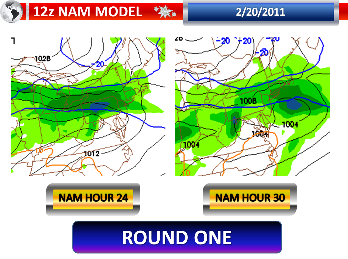
A cold front will approach from the west this evening. A pretty remarkable area of low pressure will be giving the front a boast and at the same time the low will be moving to our south. The models have shifted the axis of heavier snow northward over the past two days. This band will likely impact the areas that did not receive as much snow from this event. The latest 12z NAM guidance shows (without any mixing/temperatures taken into account) a general 2 to 6 inches of snow in Southern New Jersey with localized banding amounts of 6 to 9 inches in Southwestern New Jersey. The latest 12z GFS guidance shows a general 2 to 6 inches in Southern New Jersey. There appears to be a very sharp cutoff on both models. On the NAM, it is arguably at Interstate 195. On the GFS, it is at or just below Route 537 which runs through Burlington and Ocean Counties. The NAM has been excellent at picking up convective features and banding this season, and I do buy the banding it shows moving across Southern New Jersey leading to the higher amounts. This is what the guidance is spitting out if it were all snow, but not the forecast.

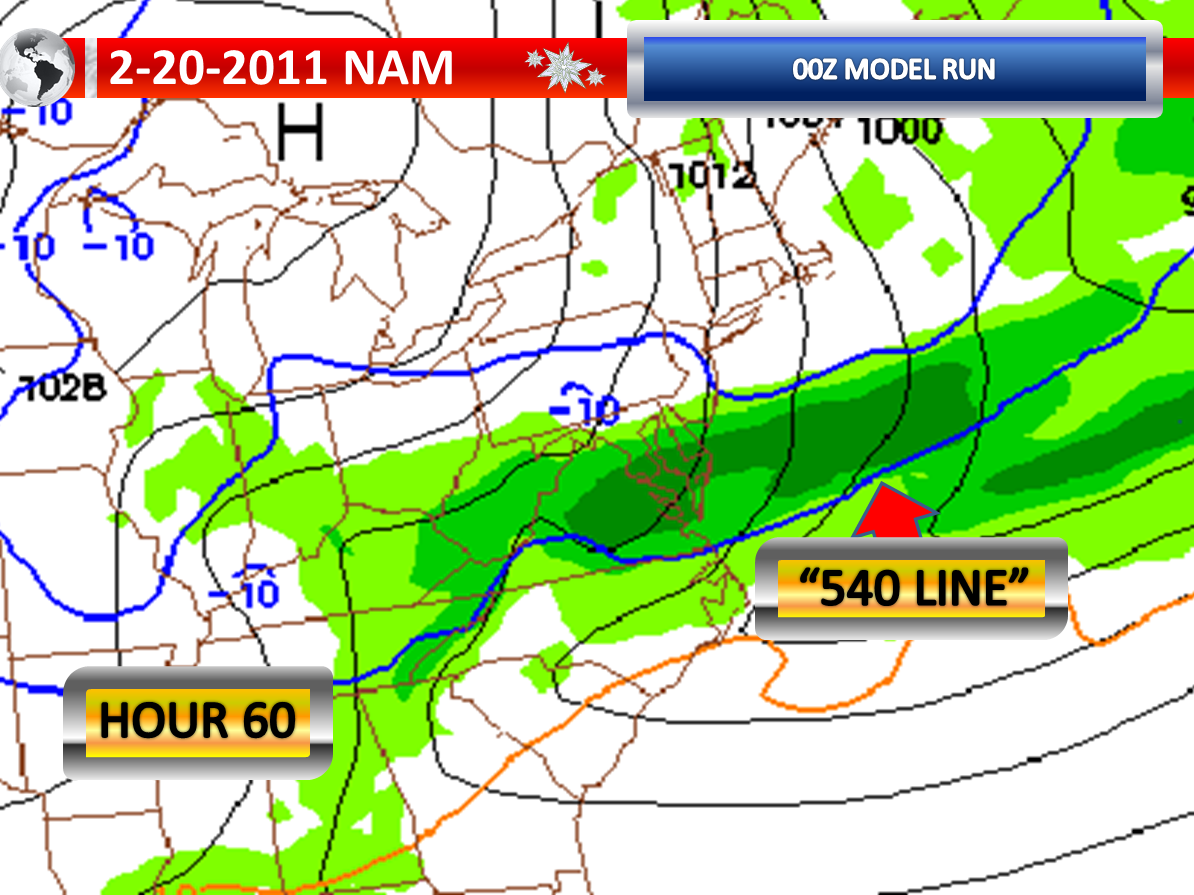
This evening, colder air will begin dropping our temperatures prior to the daylight ending. Over the north, skies could even have breaks in the clouds allowing extremely cold temperatures to settle in. In Central New Jersey, temperatures will drop through the thirties quickly to or below freezing. In Southern New Jersey, temperatures will drop from maximums anywhere between 40 and 50, depending on where you live. What will be so critical here is determining the surface temperature and the temperature all the way from top to bottom in the column. Since temperatures could initially be above 40 degrees when the precipitation begins, it could definitely start as some rain and sleet in just about everywhere that receives precipitation tonight. It is expected, based on the “540 Line” sinking to the south on both the GFS and NAM, that even if the surface is above freezing, the temperatures to air near the surface will cool with colder air advection moving in, allowing the rain to change to sleet and wet snow, even down in Cape May County. But during this process, the heaviest precipitation may be in Cape May County, but it will be warmest here. So the greater snow totals could actually fall along a corridor of the Atlantic City Expressway. It is going to be absolutely nail biting trying to pin down this snow and sleet accumulation with transitions and warmer surface temperatures. In Northern New Jersey, at least temperatures were closer to freezing when the snow started there late last night and early this morning. With all of this in consideration, I think many areas will receive 1 to 3 inches of snow. There could be a banding situation where once it is all snow and temperatures are plunging, a localized strip could pick up 2 to 6 inches of snow. Keep in mind that an advisory criterion in this part of New Jersey is two inches and warning criteria is four inches.

Gradient wise---the cutoff will fall somewhere between Interstate 195 and Route 70. This could just be like lake-effect snow where even cities and towns have very different conditions from one end to the other.

It is worth noting that previous events (very similar) over the past two decades… where banding occurred in these areas…resulted in 8 to 12 inches in a localized strip and the other event resulted in 5-9 inches. These bands ran from York County down through Gloucester and Atlantic Counties. But again, we have mixing and a warmer ground this time. Regardless, this forecast has very high busting potential.

Sunday, February 20, 2011

2/20/2011 Extended Forecast: Wintry Mix Overnight, Again Monday Night

8:35 p.m. UPDATE: The National Weather Service is now expanding the advisory to include Monmouth and Mercer Counties.


Precipitation arrives around or before Midnight.

A winter weather advisory has been issued for Sussex, Warren, Morris, Hunterdon, Middlesex, Bergen, Union, Essex, Hudson, and Passaic Counties. These areas will likely see a burst of heavy precipitation overnight with a warm front and it will also be cold enough for several hours of wet snow and sleet. Two to four inches of accumulation is quite possible in these areas, with perhaps localized higher amounts. There could even be some rain or freezing rain mixed in at times in these areas. The latest high resolution models are showing that it continues to snow and sleet in Northern New Jersey even into the morning commute. The “540 Line” on the 18z GFS and 18z NAM continues not to move north of Central New Jersey which is a change from twenty-four hours ago.

Meanwhile, in areas between Interstate 195 and the Atlantic City Expressway, there will initially be sleet and possible wet snow. A gradual rise in temperatures in this area should allow the snow and sleet to switch over to rain. The models are not painting much measurable precipitation in this area and with a faster transition expected here, I would suspect the accumulations will be limited to a coating to an inch at most. Should the precipitation be more pronounced in this area or should temperatures not respond to the warm air advection, then we could have some problems this far south as well and this will have to be handled with great caution.

From the Atlantic City Expressway and points south, the model guidance does not show much measurable precipitation at all. The lack of heavy intensity and warmer air temperatures suggests a drizzle and fog situation here with gradually rising temperatures in this area. The area will be entering the warm sector into Monday Morning and some very gusty winds may develop in the area, eventually dissipating the fog. The wind gusts could be strong for a time in this area. Should a shower form before the morning commute, it could contain some sleet pellets.

A lull is likely by midday. Temperatures will rise and will begin to drop as the evening approaches. There could be quite a contrast from north to south.

Round two, with an area of low pressure moving to our south, will be an even colder event. The change here is that the guidance has shifted the low further to the north and so has this expected aggressive band of heavier precipitation. It appears as though temperatures will rapidly drop as precipitation breaks out with this second round late Monday Night into Tuesday Morning. This means rain will likely transition to snow and sleet. There could be precipitation heavy enough for accumulations in the zone from Interstate 195 and points south. The precipitation may be heaviest in Cape May County, but this is where it will be warmest. Overall, this band is going to setup somewhere and could be quite intense where it does, even possibly containing some thunderstorms. There could be a sharp gradient in snow and sleet with this band, especially if it is a narrow intense band of snow as some of our higher resolution models show. Transitioning precipitation types, mixing, and warmer ground temperatures make the accumulation projections quite difficult with this second system. Some places could end up with 3 to 6 inches of snow, but where is the big question.

Wednesday through Friday will be impacted by any potential snow on the ground. A warm front will approach on Thursday with a strong cold front and low pressure area on Friday. Friday could end up being quite wet according to the long term guidance. The clouds and rain look to limit the temperatures in the extended, which if it was not raining would have a shot at reaching 60 degrees. The cold front timing is also faster and therefore Saturday won’t be as warm as I initially was hoping for.

Wintry Mix Threat Tonight for Some, Snow & Sleet Threat Late Monday into Tuesday for Some


Trouble could be brewing.

System number one is only about eighteen hours away. The computer model guidance this morning is much colder and shows more available liquid with the 12z Guidance for Northern and Central New Jersey. The “540 Line” on both models never really lifts through Central New Jersey on both the GFS and NAM models during the heaviest precipitation. Temperatures this morning are running several degrees colder than the guidance indicated. The column also seems to be colder when peaking at the atmospheric profiles.

It would appear as though some areas may see the precipitation start as wet snow, with a mixture of sleet where the precipitation is heavy enough. There still is expected to be a transition to rain in Central New Jersey, but this could be delayed until the steadier precipitation turns lighter and more sporadic. Meanwhile, it still appears that south of the Atlantic City Expressway, the precipitation will be light and the likely conditions would be fog and drizzle. But, if heavier showers should occur here, they may contain some sleet pellets initially. It could be a very interesting temperatures situation on Monday Morning with a huge difference from north to south.

The models continue to show a lull during Monday, around midday. A second low pressure area will pass to our south on Monday Night into Tuesday. However, the 12z Guidance has trended further to the north. As you can see from the previous post, the NAM model has the heavy axis of precipitation in Delaware last night. The latest 12z NAM model shows the heart of this site’s forecast area seeing that band of heavier precipitation. Even the GFS from 12z has shifted further to the north, showing the heavier band including more of Southern New Jersey. The models also seem to be a bit colder with this storm as well, indicating a faster transition to sleet and wet snow.

With the transitioning precipitation and the bouncing back and forth on the models, it is very hard to make a snow and sleet graphic prediction. I think someone could end up with as much as four to six inches of snow and sleet when this is all said and done…but where is the question that really doesn’t have an answer at this late hour.

Burst of Snow & Sleet Monday Night into Tuesday or Nothing?


The Monday Night into Tuesday possible snow and sleet event is now about 54 to 60 hours away. There is a lot to iron out between now and Monday Night. The 00z guidance is now in.

The GFS from 00z suggests that the area of low pressure passing to our south will be closer to our region. This track would be somewhat warmer as a result, with the “540 Line” pushing through our region as the precipitation begins to fall. This would indicate a transition from rain to sleet and snow in areas that receive precipitation. The GFS shows a fairly decent burst of precipitation in Southern New Jersey as it continues to get colder. It looks like the model is showing some convective banding, so even some thunderstorms would be possible. Notice the sharp cutoff though. New Brunswick is not getting anything measurable while Hammonton, Atlantic City, and Cape May are getting heavy precipitation. But here is the thing if this solution were correct. Is Cape May really going to see it change to all wet snow and sleet with the “540 Line” in the location it is? This could be a situation where the heaviest burst doesn’t necessarily coincide with temperatures supportive for snow. It will be a close call.

Meanwhile, the NAM shows the “540 Line” almost down into the Delmarva as the precipitation begins. But even here, some rain or mix initially would occur where it precipitates. However, it shows such a strong push of colder air, that the storm is actually suppressed by the heavier and denser air and practically misses most of New Jersey with the exception of Cape May. It shows intense banding though in Southern Delaware. So while it is cold for accumulations on the NAM, there is literally precipitation that will be non-existent if this solution were correct.

At this point, I continue to believe Southern New Jersey has the best chance at observing accumulations, if any at all. Will the surface be too warm? Will it be precipitating at all? Will the precipitation be transitioning to all frozen? These are three questions which do not have definitive answers as of early Sunday Morning.

Saturday, February 19, 2011

2/19/2011 Extended Forecast


745 UPDATE: Wind Advisory until Midnight for 40-50 MPH gusts.

New Jersey continues to deal with the impact of this nasty wind storm that moved through today. Thousands remain without power, especially across Southern New Jersey. The high wind warning (wind advisory in NE NJ) remains in effect until late tonight. 25 to 35 MPH sustained winds with gusts of 40 to 55 MPH will eventually diminish this evening...the 55+ gusts appear to be finally over with. There appears to be one more wave of high winds passing through for the next few hours. As long as the winds gust over 40 MPH, outages will continue to be an issue and I would not be surprised if the warning is downgraded to an advisory, but kept up for a longer period of time into Sunday Morning. Enhanced fire danger prompting the red flag warning in portions of the area should diminish with the wind decrease expected.

I do see the snow showers and snow flurries on the radar with the NE Flow impacting Northwestern and North-Central New Jersey. Above freezing temperatures and overall light echoes means nothing more than a pretty scene with the wind blown flakes.

A warm front is projected to cross our region Sunday Evening into Monday Morning. The sun will be out early on Sunday with high clouds filtering in by late morning. Clouds will thicken throughout Sunday Afternoon. Temperatures may fall back a few degrees in the evening hours, coming off of our high temperatures of around 40 degrees. The clouds can play two roles here. One, they can keep the temperatures from rising to 40 degrees. Two, they can prevent temperatures from falling back to around freezing in the evening. It will be tricky in trying to determine what role the clouds will play exactly.

The 18z NAM seems to be in line with my current thinking on the precipitation with the warm front and this model does not show much measurable precipitation. Most of it is kept North and West of the Garden State. If this is correct, with light precipitation and borderline temperatures, it would lead me to believe it would be more of a drizzle with any embedded heavier echoes producing some sleet. Overall, I doubt the mixing with the warm front will be a big deal. Around Sussex County, some freezing drizzle or freezing rain is possible whereas this is the best area for temperatures to fall back to around freezing prior to the precipitation arrival. However, I did look at the 18z GFS which does show a good slug of precipitation across Central and Northern New Jersey as it is cold enough for some sleet and wet snow to mix with rain, with snow and sleet in Sussex County. This is going to come down to what forecasters call a nowcast, based on trends and Doppler radar. Tomorrow afternoon is when you want to look for some updates.

The increasing low-level moisture will allow for some low cloud development, especially if the precipitation is lighter and the wind is calm for a time, which doesn’t allow for the air to be mixed. Another thing I will be watching with the warm frontal passage is a period of very gusty winds in Southern New Jersey and Delaware at some point. It was just a few weeks ago that a round of strong winds knocked out some power to a few thousand. We could have quite a temperature contrast from Northwest to Southeast on Monday. Of course the gusty wind would end any foggy conditions.

Temperatures will begin to fall off on Monday as the first system pushes away and drags a cold front through our region. There could be a gusty line of showers with the cold front, although the edge of the colder air could be arguably not defined as a front. An area of low pressure will arrive for Monday Night into Tuesday, but pass to our south. Initially, the precipitation will likely start as some rain and as colder air in, expect a transition to wet snow and sleet. It continues to appear as though the heaviest axis of moisture will slide across Southern New Jersey. However, the models have been shifting this axis with each run and it bears watching. Warmer ground temperatures and surface air temperatures above freezing support a wet snow and may hinder the accumulation, especially if there is light intensity. I think your best chances for accumulations, if at all, is between Mount Holly and Toms River down through Cape May.

Another quick rebound is likely by the end of the forecast period. Temperatures once again could rise into the sixties. We could have another warm front bring a chance of rain showers on Friday.

Damaging Winds Expected This Afternoon-Evening


By mid-afternoon, I expect more than ten-thousand customers without electric service throughout New Jersey. We already have thousands without electric service currently. I could even see 20,000 to 40,000 customers losing electric by early this evening. The latest guidance is showing wind gusts of around 60 knots which is the equivalent of 70 MPH. A high wind warning remains in effect through 9:00 p.m. with a wind advisory for northeastern portions of New Jersey.

Wind gusts of 60-70 MPH could certainly do structural damage to roofs and knock down weak structures such as inflatable buildings. Debris will fly in the roadway if left outside. Whole trees, large branches, and utility lines could also be lying in the road so drive carefully if you intend to travel today. Driving with any vehicle could be difficult and the higher gusts could overturn any high profile vehicle.
A high wind warning implies dangerous windy conditions are likely.

A red flag warning remains in effect for Central and Southern New Jersey. Low humidity and damaging winds will fan any flames and cause any flames to spiral quickly out of control posing a life-threatning situation should a fire start and spread to adjacent structures/people.

Links to monitor power outages:

Jersey Central Power and Light [New Jersey]

Public Service Electric and Gas [Western, Central, and Northern New Jersey]

Atlantic City Electric [South Jersey]

Orange and Rockland [Extreme North Jersey]

Friday, February 18, 2011

High Wind Warning


The high wind watch has been upgraded to a high wind warning. This is the most serious wind product you can have for your area...outside a tropical weather wind product or a severe thunderstorm product.

Sustained winds of 40 MPH or greater

and/or

Wind Gusts of 58 MPH or greater

That is the criteria for a high wind warning.

NE New Jersey remains under a wind advisory for now.

2/18/2011 Extended Forecast: High, Damaging Winds Saturday, Snow?

This took 2 hours to prepare so enjoy! A few very isolated t-storms (only source right here to predict such) will push offshore by 8:30 p.m.


Saturday is going to be a very windy day, with the possibility for damaging winds. I have been hitting hard on this high wind potential for several days now. The latest information suggests sustained winds of 25 to 35 MPH with frequent wind gusts between 50 and 60 MPH. This type of wind, even without a soaked ground, can bring down whole, healthy trees. Weaker trees and branches will definitely have an opportunity to come down with the strong gusts. If we see a lot of gusting over 55 MPH, I think we could see quite a few areas lose electricity at least for a few hours. The ground saturation varies across New Jersey. The recent melting of the snow has kept the ground fairly moist below the surface in Central and Southern New Jersey. With the roots rooted in the more moist part of the ground, this could lead to an increase in downed trees, although this is not a ground absolutely saturated. The top half inch though is fairly dry or will be rapidly drying out as the wind picks up and the humidity drops causing a concern for some enhanced fire danger. By the way, wind gust projector is showing nothing but red which is not a good sign. Widespread 50 Knot gusts or 58 MPH & the map remains unchanged from 1:00 p.m. to 4:00 p.m.


With this forecast matching up well with the National Weather Service, they have issued products that are supportive of my concerns. A high wind watch has been issued for Northwestern, Central, and Southern New Jersey for Saturday. A high wind watch means that sustained winds of 40 MPH or greater and/or frequent wind gusts of 58 MPH or greater are possible with thirty-six hours. If high winds become imminent or begin to occur, a high wind warning will likely be issued. Sometimes, the winds may be lighter than originally thought and they could replace the watch with an advisory. Northeastern New Jersey’s five counties are under a wind advisory which implies that sustained winds of 31 to 39 MPH or frequent wind gusts between 46 and 57 MPH are imminent or occurring. However, the advisory statement does mention that the advisory may need to be upgraded to a warning. A red flag warning, for extremely dangerous fire growth, is in effect for mostly southern portions of New Jersey.

Here is the summary:

High Wind Watch: Sussex, Morris, Warren, Hunterdon, Somerset, Middlesex, Mercer, Monmouth, Ocean, Burlington, Atlantic, Camden, Gloucester, Salem, Cumberland, and Cape May Counties.

Wind Advisory: Passaic, Bergen, Hudson, Union, and Essex Counties.

Red Flag Warning: Monmouth, Ocean, Burlington, Atlantic, Camden, Gloucester, Salem, Cumberland, and Cape May Counties.


Sunday, we have morning sunshine likely. Clouds will begin to increase Sunday Afternoon and Sunday Evening. A warm front will approach the region on Sunday Night. The timing of the thicker clouds will be critical as any breaks could allow from some quick cooling, before temperatures begin to rise again. Temperatures will be upper thirties to lower forties on Sunday with temperatures falling back as the sun settles for the evening. The latest 18z guidance shows the bulk of the precipitation staying north and west of our area, with perhaps just some light precipitation. The lighter precipitation means less of a chance of mixing and perhaps we would just be dealing with some drizzle or freezing drizzle. However, any heavier show could initially cause some sleet pellets or wet snowflakes. Some low clouds are possible on Sunday Night into Monday with increasing low-level moisture. On Monday, the first low moves away from the region and we will see a lull in precipitation, with again perhaps a few showers and some drizzle. Temperatures continue to appear as though they will be quite tricky as the warm sector may not get through our entire region. The warm sector could push temperatures up to near 60 degrees while north of the front temperatures are around 40 degrees. Right now, I will insert highs in the lower fifties, although they could be much higher or much lower.

I mentioned a lull, because it still appears a second system will enter our region for Monday Night into Tuesday. Behind the first low pressure area, a more northerly component will become established driving in colder air. This means that while precipitation could initially begin as rain or a mix, there could definitely be a transition to sleet and wet snow by Tuesday Morning. There could be accumulations of snow and sleet across portions of the area. Some of the models show a pretty good burst of snow prior or during the morning commute, roughly 84 hours from now. High temperatures on Tuesday will be in the thirties. Rain prior to the snow, a warmer ground, and higher sun angles are all factors that must be considered when forecasting snowfall amounts. As on person told me yesterday, “Say it isn’t snow, Doug!”