Showing posts with label Windy. Show all posts

Wednesday, April 13, 2011

A Windy Storm Ending


A windy storm is slowly moving out.

NEW JERSEY

...ATLANTIC COUNTY...
ATLANTIC CITY 37 935 PM 4/12

...BURLINGTON COUNTY...
WRIGHTSTOWN 44 1033 PM 4/12
SOUTHAMPTON TWP 40 1043 PM 4/12
CHATSWORTH 39 1000 PM 4/12
MOUNT HOLLY AIRPORT 38 943 PM 4/12

...CAPE MAY COUNTY...
CAPE MAY 41 510 PM 4/12
OCEAN CITY 40 855 PM 4/12

...CUMBERLAND COUNTY...
MILLVILLE 33 458 PM 4/12

...MERCER COUNTY...
TRENTON 39 1052 PM 4/12

...MIDDLESEX COUNTY...
PERTH AMBOY 44 135 AM 4/13

...MONMOUTH COUNTY...
MONMOUTH BEACH 47 100 AM 4/13
SANDY HOOK 46 153 AM 4/13
KEANSBURG 44 100 AM 4/13
BELMAR 39 1135 PM 4/12

...OCEAN COUNTY...
SEASIDE HEIGHTS 49 1209 AM 4/13
BARNEGAT 47 1150 PM 4/12
BRICK TWP 47 1155 PM 4/12
TUCKERTON 44 945 PM 4/12
TOMS RIVER 33 1035 PM 4/12


The surface low is over Delaware and it will northward through this evening. Until then, fog and drizzle may exist.

An isolated t-storm may develop if any sunshine comes out before sunset...but a gradual return to sunshine may develop late this evening...late enough that it precludes any real instability to develop before the triggering mechanism departs.

Heavy rain is on the way for Saturday, and more t-storms.

Thursday, March 10, 2011

Very Heavy Rains Moving In, Power Outages Reported


Several thousand people throughout the evening have lost power. There are still power outages being reported by Atlantic City Electric and Public Service Electric and Gas. Earlier, Jersey Central Power and Light was reporting a couple thousand without electric, but the number has come down. Wind gusts past 45 MPH were reported along the coastline.

Meanwhile, a band of heavy rain has setup across New Jersey. Of more concern is an area of heavy rain moving north-northeast from Southern Maryland which will likely produce up to an inch in a short period of time in portions of New Jersey.

Numerous flood warnings have been issued for New Jersey.

Windy, Excessive Rains Late Tonight


Update at 3:07 p.m.Atlantic City now is reporting a wind gust of 39 MPH.
Wildwood now is reporting a wind gust of 30 MPH.
Belmar now is reporting a wind gust of 31 MPH.


East-southeast winds are picking up across New Jersey as the area of low pressure is strengthening and the gradient is tightening. Atlantic City now has a wind gust at 32 MPH in the past hour. These winds should increase every hour for the next several hours and probably will remain strong until a strong line of heavy thunderstorms (which will bring torrential rains) passes through late tonight into early Friday Morning.

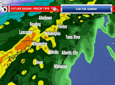
Meanwhile, scattered areas of rain showers will fill in as the night progresses. The models are still indicating excessive rainfall late tonight and early on Friday Morning. The future radar, high resolution models shows this very nicely. You can see a nice convective type feature moves through around 2:00 a.m. Friday.


Heavy Rain Moves In


Round one of the heavy rain is now taking over Southwestern New Jersey and Northwestern New Jersey. The very sharp cutoff line is slowly moving east-northeast and will take more and more areas into the rain as the morning and early afternoon progresses. Flood advisories have already been posted in advance of this line for the majority of New Jersey. A flood watch remains in effect for all 21 New Jersey counties. A coastal flood watch continues for Salem, Camden, Gloucester, and Northwestern Burlington Counties for areas along the Delaware River. Flood warnings remain in effect along the Passaic River basin where the flood waters never receded from the previous heavy rain event on Sunday.

East-southeast winds are so far sustained 15 to 25 MPH with gusts to about 35 MPH. As the low pressure areas strengthen and get closer to our region, the gradient should tighten further. The strongest winds will probably be late this afternoon and early this evening. Gusts should be pretty significant in our eastern counties for a time.

Both the GFS and NAM agree that there will be torrential rain falling in the evening or 12 hours from now.

Sunday, March 6, 2011

Very Heavy Rain and Thunderstorms On The Way


The threat for heavy rain this evening and overnight continues across New Jersey. While we have had some scattered heavy showers this morning, the main course is waiting to impact us. The radar picture just after noon showed a surface low beginning to develop and intensify along a slow moving cold front moving eastward. Rich gulf moisture and moisture from the Atlantic can be seen injecting itself into the surface low. The low is currently around the Southern Appalachians. The low will move into the Carolina Piedmont and eventually eject northward into our region. As the system gets closer to our region, both the front and the low will begin to develop some heavy, steady rainfall. The heaviest axis of rain will setup in Northwestern New Jersey down through Eastern Pennsylvania. The NAM and GFS models show even heavy rain in Cape May, but I am still expecting lesser amounts in our southeastern counties. The higher resolution models aren’t as robust as the morning GFS and NAM on torrential rain at the shore points.

With New Jersey in the right guardant of this low, I expect it to turn windy for at least a short period of time. Wind gusts of near or in excess of 50 MPH certainly are possible as the front pushes through and the surface low moves to the north and east. With the wet ground, these wind gusts may be able to uproot trees. The heavier rain could be able to transport the stronger winds to the surface. The right quadrant also means that there could be some marginal instability for some thunderstorms. The models indicate low-topped convection with the actual surface low itself, regardless of if you will be on the right side. Any convection will be underneath all of this heavy rain. These situations pose a challenge to detect wet microbursts or a weak tornado, but these are certainly possible with any thunderstorm given the setup.

The high resolution models show cold air catching up with the precipitation on Monday Morning prior to and during the morning commute. It could be cold enough to change the precipitation to sleet and wet snow in our Northwestern Counties. The setup leaves me still with some doubts, but it can happen and one must maintain an eye on the credible models suggesting this possibility.

Friday, February 18, 2011

High Wind Warning


The high wind watch has been upgraded to a high wind warning. This is the most serious wind product you can have for your area...outside a tropical weather wind product or a severe thunderstorm product.

Sustained winds of 40 MPH or greater

and/or

Wind Gusts of 58 MPH or greater

That is the criteria for a high wind warning.

NE New Jersey remains under a wind advisory for now.

2/18/2011 Extended Forecast: High, Damaging Winds Saturday, Snow?

This took 2 hours to prepare so enjoy! A few very isolated t-storms (only source right here to predict such) will push offshore by 8:30 p.m.


Saturday is going to be a very windy day, with the possibility for damaging winds. I have been hitting hard on this high wind potential for several days now. The latest information suggests sustained winds of 25 to 35 MPH with frequent wind gusts between 50 and 60 MPH. This type of wind, even without a soaked ground, can bring down whole, healthy trees. Weaker trees and branches will definitely have an opportunity to come down with the strong gusts. If we see a lot of gusting over 55 MPH, I think we could see quite a few areas lose electricity at least for a few hours. The ground saturation varies across New Jersey. The recent melting of the snow has kept the ground fairly moist below the surface in Central and Southern New Jersey. With the roots rooted in the more moist part of the ground, this could lead to an increase in downed trees, although this is not a ground absolutely saturated. The top half inch though is fairly dry or will be rapidly drying out as the wind picks up and the humidity drops causing a concern for some enhanced fire danger. By the way, wind gust projector is showing nothing but red which is not a good sign. Widespread 50 Knot gusts or 58 MPH & the map remains unchanged from 1:00 p.m. to 4:00 p.m.


With this forecast matching up well with the National Weather Service, they have issued products that are supportive of my concerns. A high wind watch has been issued for Northwestern, Central, and Southern New Jersey for Saturday. A high wind watch means that sustained winds of 40 MPH or greater and/or frequent wind gusts of 58 MPH or greater are possible with thirty-six hours. If high winds become imminent or begin to occur, a high wind warning will likely be issued. Sometimes, the winds may be lighter than originally thought and they could replace the watch with an advisory. Northeastern New Jersey’s five counties are under a wind advisory which implies that sustained winds of 31 to 39 MPH or frequent wind gusts between 46 and 57 MPH are imminent or occurring. However, the advisory statement does mention that the advisory may need to be upgraded to a warning. A red flag warning, for extremely dangerous fire growth, is in effect for mostly southern portions of New Jersey.

Here is the summary:

High Wind Watch: Sussex, Morris, Warren, Hunterdon, Somerset, Middlesex, Mercer, Monmouth, Ocean, Burlington, Atlantic, Camden, Gloucester, Salem, Cumberland, and Cape May Counties.

Wind Advisory: Passaic, Bergen, Hudson, Union, and Essex Counties.

Red Flag Warning: Monmouth, Ocean, Burlington, Atlantic, Camden, Gloucester, Salem, Cumberland, and Cape May Counties.


Sunday, we have morning sunshine likely. Clouds will begin to increase Sunday Afternoon and Sunday Evening. A warm front will approach the region on Sunday Night. The timing of the thicker clouds will be critical as any breaks could allow from some quick cooling, before temperatures begin to rise again. Temperatures will be upper thirties to lower forties on Sunday with temperatures falling back as the sun settles for the evening. The latest 18z guidance shows the bulk of the precipitation staying north and west of our area, with perhaps just some light precipitation. The lighter precipitation means less of a chance of mixing and perhaps we would just be dealing with some drizzle or freezing drizzle. However, any heavier show could initially cause some sleet pellets or wet snowflakes. Some low clouds are possible on Sunday Night into Monday with increasing low-level moisture. On Monday, the first low moves away from the region and we will see a lull in precipitation, with again perhaps a few showers and some drizzle. Temperatures continue to appear as though they will be quite tricky as the warm sector may not get through our entire region. The warm sector could push temperatures up to near 60 degrees while north of the front temperatures are around 40 degrees. Right now, I will insert highs in the lower fifties, although they could be much higher or much lower.

I mentioned a lull, because it still appears a second system will enter our region for Monday Night into Tuesday. Behind the first low pressure area, a more northerly component will become established driving in colder air. This means that while precipitation could initially begin as rain or a mix, there could definitely be a transition to sleet and wet snow by Tuesday Morning. There could be accumulations of snow and sleet across portions of the area. Some of the models show a pretty good burst of snow prior or during the morning commute, roughly 84 hours from now. High temperatures on Tuesday will be in the thirties. Rain prior to the snow, a warmer ground, and higher sun angles are all factors that must be considered when forecasting snowfall amounts. As on person told me yesterday, “Say it isn’t snow, Doug!”

Tuesday, February 15, 2011

Breezy Today


Wind gusts have now lowered into the 20-35 MPH range today. The winds will continue to decrease throughout the afternoon hours today. However, the low relative humidity and drying surface will create a bit of an enhanced fire danger concern in Southern New Jersey where snow cover is non-existent. I still think the lack of very mild temperatures and also a ground that still is fairly moist underneath the first half-inch of soil from the recent melt will preclude full-scale red flag conditions.

Monday, February 14, 2011

Still Windy, Peak Gusts Behind Us


There is no doubt that the hardest hit part of New Jersey with this wind event was Southern New Jersey. Atlantic City Electric has reported several thousand without power in various sections of their service territory throughout this event. They now have isolated pockets of a few hundred without power, but the numbers appear to be dwindling.

The wind gusts and sustained wind speeds seem to be leveling off. The current gusts on the observations are mainly between 30 and 40 MPH, just below the criteria for an advisory. The wind advisory continues. Some isolated wind gusts up to 50 MPH are still possible for the next few hours, but these will be more isolated in nature. The peak gusts were late this afternoon and early this evening when winds were gusting between 45 and 55 MPH as the front passed through.

NEW JERSEY

...ANZ430...
SHIP JOHN SHOAL NOS 47 300 PM 2/14

...ATLANTIC COUNTY...
ATLANTIC CITY AIRPOR 47 846 PM 2/14

...BURLINGTON COUNTY...
MOUNT HOLLY AIRPORT 46 327 PM 2/14

...CUMBERLAND COUNTY...
MILLVILLE 46 555 PM 2/14

...MONMOUTH COUNTY...
SANDY HOOK 50 405 PM 2/14
KEANSBURG 48 1000 PM 2/14
MONMOUTH BEACH 48 950 PM 2/14

...MORRIS COUNTY...
MORRISTOWN 46 345 PM 2/14

...OCEAN COUNTY...
BRICK TWP 52 400 PM 2/14
BARNEGAT BAY 50 300 PM 2/14
TUCKERTON 49 740 PM 2/14
BARNEGAT LIGHT 49 500 PM 2/14
HARVEY CEDARS 46 400 PM 2/14
LAKEHURST AIRPORT 46 212 PM 2/14
LONG BEACH PARK 45 244 PM 2/14

...SUSSEX COUNTY...
HIGH POINT 50 900 PM 2/14

...WARREN COUNTY...
HACKETTSTOWN 48 300 PM 2/14

Wind Advisory This Afternoon into Early Tuesday


A wind advisory has been issued for all of New Jersey from this afternoon into early Tuesday Morning. Southerly winds will increase ahead of a cold front this afternoon. However, the strongest winds will be reserved for late afternoon into tonight as a cold front sweeps through the region and shifts the wind direction to west-northwest. Winds will likely become sustained between 20 and 35 MPH with gusts of 45 to 55 MPH. There is a possibility some wind gusts approach 60 MPH late today for an hour or two after the frontal passage. A wind advisory is issued when sustained winds of 31 to 39 MPH or frequent wind gusts of 46 to 57 MPH are imminent or occurring. The next level would be a high wind warning for sustained winds of 40 MPH or greater or frequent wind gusts of 58 MPH or greater.

I have just posted the latest rendered version of wind gust projector. As you see, widespread orange and some red appears around 7:00 p.m. whic is 35-45 KNOTS of wind.


Sunday, February 13, 2011

Very Windy Monday


It is looking more and more likely that wind gusts on Monday could be very strong, which could down some trees and utility lines. The latest guidance continues to suggest wind gusts between 45 and 55 MPH across most of the region.

The wind may come in two rounds. The first round will be with a warm push of air ahead of a surface boundary moving through in the morning. Southwest winds could definitely gust above 40 MPH, especially along the coastal plain. The second round is with the cold air advection moving in from the northwest behind the boundary. The peak gusts with this will occur late in the afternoon into the evening hours.

Tuesday, February 8, 2011

Wind Advisory Today, Strong Winds Expected


All of Central and Southern New Jersey has been placed under a wind advisory into early this evening. A wind advisory is issued when sustained winds of 31 to 39 MPH or frequent wind gusts of 46 to 57 MPH are imminent or occurring.

At this point, the soundings are suggesting sustained winds of 25 to 35 MPH with wind gusts between 40 and 50 MPH. I still believe there could be isolated wind gusts in excess of 50 MPH. These wind speeds will certainly down weakened trees and weakened branches. Some scattered power outages are likely later today as the peak gusts are realized.

A secondary reinforcement of colder air this afternoon could be accompanied with snow showers and snow squalls, with the highest chances north of Route 1. We did have rain and some snow showers this morning that came through between 4:00 a.m. and 5:00 a.m.

Saturday, February 5, 2011

Warm Front Winds Cause Power Outages


Strong wind gusts within the past few hours due to a warm front has caused some scattered power outages. Jersey Central Power & Light and Atlantic City Electric are reporting some power outages of significane.

Woodland: 43 MPH @ 8:55 p.m.
Belmar: 40 MPH @ 8:54 p.m.
Atlantic City: 41 MPH @ 8:54 p.m.
Southampton: 39 MPH @ 8:06 p.m.

Dense Fog Blown Out By Wind


Very strong winds across parts of New Jersey within the past hour....unexpected...have downed trees and wires and have ended our dense fog.

Compare the wind gusts with the temperatures....clearly you can see a relationship between the gusts and the temperatures.