Showing posts with label Heavy Rain. Show all posts

Friday, April 22, 2011

More Soaking Rain and a T-Storm Late into Saturday


Tonight and especially Saturday Morning will be wet. Rain develops this evening from west to east. The rain will become heavy at times on Saturday Morning and move out of the region slowly on Saturday Afternoon. There should be some thunderstorms as well. 1 to 2 inches of rain seems to be reasonable at this point. Renewed flooding across the swollen rivers, creeks, and streams is possible given how well above normal they are running.

Much of North and Central New Jersey needs 1 to 2 inches of rain in six hours to begin to cause flash flooding. Southwestern New Jersey into Monmouth County needs about 2 to 3 inches to flooding with the remainder of the region needing amounts in excess of 3 inches for problems to begin. Much of this rain will come in 10-14 hours and this is worth watching...especially with thunderstorms are possiblilty as the North American Model from 12z suggests. While this event will be not nearly as intense as last weekend...things are just saturated out there from past few soakers.

To me, on the map, while the instability is not nearly as strong as the day we had the slight risk, enough it will be present that there could be a few strong to severe thunderstorms. As of early this morning, the Storm Prediction Center has placed the region under a "see text" risk for severe thunderstorms. I would say the chances are greater than the other day despite their lower probabilities at the moment.

Saturday, April 16, 2011

Major Storm: Numerous Flood Warnings, Near-Record Flooding Near Philadelphia

Just after 10:50 p.m., the National Weather Service issued a special weather statement regarding near-record, major tidal flooding in addition to the coastal flood warning...

At Philadelphia, high tide occurs at 1:12 a.m. with a forecast high-tide level 10.5 feet above mean lower low water. The last time the tide level reached 10 feet at Philadelphia was on December 11, 1992.

The record level is 10.8 feet which occured on November 25, 1950. The National Weather Service expects severe flooding according to the statement and is advising all residents along the tidal areas to pay close attention to rising waters.

At this hour, nearly every county in our coverage area has been placed under a flood warning due to the excessive rainfall. Flooding is especially dangerous at night...turn around and don't drown.

Very Windy and Wet This Evening and Tonight


Major storm headed towards the region this evening into tonight.

All of North and most of Central New Jersey is now under a flood watch. The NAM has widespread purple coloring indicating a quick 1.50 to 1.75 inches of rain in less than six hours during the time frame of convection which I suspect may lead to some localized flash flooding. Total rainfall of 1.75 to 2.50 inches looks to be a good bet for much of the region. Bucks, Montgomery, Eastern Berks, and Eastern Lehigh Counties into North-Central New Jersey need 1 to 2 inches in less than 6 hours for flash flooding to begin. Elsewhere in Pennsylvania…2 to 3 inches of rain would be needed for flash flooding to begin. In Southern New Jersey, rainfall amounts of 3 to 4 inches would be needed for flash flooding to begin and the sandier soil will make this area less vulnerable to flooding. If the NAM is correct, the heaviest rain would be right over the Delaware River and Interstate 95 corridor.


We also may be dealing with thunderstorms that could contain damaging wind gusts. Right now, the Storm Prediction Center has the slight risk for severe thunderstorms for portions of Southern New Jersey. I think it is possible that they will extend the risk area further northward in later outlooks. The North American Model and some of the high resolution models show clearly that a line of convection… pushing from west to east between 8:00 p.m. and 11:00 p.m. …will impact the region. Basically, a low or meso-low will develop a cold front pushing towards our region. The low will energize the front. Moisture will be streaming in from the fetch off the Atlantic and combine with the Gulf Moisture that is open for business. All of this suggests a super soaking and a good feed into a line of convection. The National Weather Service is concerned significant wind damage may occur east of this line in New Jersey and I couldn't agree with them more.

We also will be dealing with wind issues that are non-convective related. We have had some decent soakings and this will be another one. The ground will be wet enough to be supportive of an increased risk for trees to become uprooted in strong winds. Unfortunately, it looks like the jet intensifies by mid-evening during the timing of the heavy rain which could transfer the momentum down to the surface. Non-thunderstorm wind gusts of 40 to 50 MPH appear likely, perhaps higher than 50 MPH along the coastline. The National Weather Service has issued a wind advisory which implies sustained winds of 31 to 39 MPH or frequent wind gusts of 46 to 57 MPH are imminent or occurring. This is in effect from noon today until midnight tonight. The gradient looks tight enough that even when it is not raining...gusts of around 45 MPH will occur.

The strong onshore winds will also pose a risk for widespread minor coastal flooding, with scattered areas of moderate coastal flooding. A coastal flood warning has been issued for the tidal areas of the Delaware River and the entire New Jersey/Delaware Atlantic coastline.

* AT SANDY HOOK... NEW JERSEY (RARITAN BAY)... HIGH TIDE OCCURS
AT 720 PM... WITH A FORECAST TIDE LEVEL OF 7.5 TO 8.0 FEET
ABOVE MEAN LOWER LOW WATER.

* AT SEASIDE HEIGHTS... NEW JERSEY (OCEANFRONT)... HIGH TIDE
OCCURS AT 650 PM... WITH A FORECAST TIDE LEVEL NEAR 7.0 FEET
ABOVE MEAN LOWER LOW WATER.

* AT ATLANTIC CITY... NEW JERSEY (OCEANFRONT)... HIGH TIDE
OCCURS AT 657 PM... WITH A FORECAST TIDE LEVEL NEAR 7.0 FEET
ABOVE MEAN LOWER LOW WATER.

* AT CAPE MAY... NEW JERSEY (OCEANFRONT)... HIGH TIDE OCCURS AT
731 PM... WITH A FORECAST TIDE LEVEL OF 7.5 TO 8.0 FEET ABOVE
MEAN LOWER LOW WATER.

* AT BREAKWATER HARBOR... DELAWARE (DELAWARE BAY)... HIGH TIDE
OCCURS AT 809 PM... WITH A FORECAST TIDE LEVEL NEAR 7.0 FEET
ABOVE MEAN LOWER LOW WATER.

* AT REEDY POINT... DELAWARE (DELAWARE BAY)... HIGH TIDE OCCURS
AT 1041 PM... WITH A FORECAST TIDE LEVEL NEAR 8.5 FEET ABOVE
MEAN LOWER LOW WATER.

* AT PHILADELPHIA... PENNSYLVANIA (DELAWARE RIVER)... HIGH TIDE
OCCURS AT 112 AM SUNDAY... WITH A FORECAST TIDE LEVEL OF 9.0 TO
9.5 FEET ABOVE MEAN LOWER LOW WATER.

* HIGH TIDE OCCURS ON BACK BAYS AND TIDAL TRIBUTARIES LATER THAN
IT DOES ALONG THE OCEANFRONT.

* WAVES...WAVE HEIGHTS IN THE SURF ZONE ALONG THE OCEANFRONT MAY
BE IN THE 5 TO 8 FOOT RANGE.

Friday, April 15, 2011

Major Storm Saturday P.M....Widespread Issues


A major rain and wind event is anticipated for Saturday, especially Saturday Night into early on Sunday Morning. The system has the potential to create moderate coastal flooding, damaging winds, flash flooding/flooding, and coastal flooding.

A strengthening low pressure system is moving eastward towards the Great Lakes and in response a cold front will approach our region on Saturday. A significant wave of low pressure is anticipated to develop along the front which will energize it further. A fetch off the Atlantic Ocean and support from the Gulf of Mexico should be capable of causing a huge intensification in the rain over our area. Therefore, several inches of rain may occur and it could come in a 6 to 12 hour period, introducing the possibility of localized flash flooding. At this point, 1.50” to 3.50” of rain is looking like a very good possibility. If the rain doesn’t fall quick enough for flash flooding, these rainfall amounts could be very well capable of causing creeks and streams to rise to or over their banks. The North American Model is showing a good slug of purple on the 18z run, therefore I think the proposal of an excessive rainfall event is gaining more confidence.

There is an opportunity for some strong winds across the region. A strong jet will develop aloft and maximize over our region during the evening hours. Heavy rain will transport the strong winds down to the surface, but even without the rain…some of this wind will be capable of mixing to the surface with the tightening gradient. Thunderstorms, which are expected to occur any time after 6:00 p.m., will be even more capable of producing damaging wind gusts. Right now, a widespread severe weather outbreak is expected south of the region by the Storm Prediction Center where sunshine and warmer temperatures will allow for more destabilization of the atmosphere resulting in stronger downdrafts. However, we could definitely see at least scattered thunderstorms with damaging winds and I will continue to monitor the latest forecasts from the Storm Prediction Center. Right now, South Jersey is under a “see text” or a 5% risk for severe thunderstorms. The National Weather Service has issued a wind advisory meaning conditions are imminent or occurring in which sustained winds of 31 to 39 MPH or frequent gusts of 46 to 57 MPH from Noon to Midnight on Saturday. This product is issued for non-convective wind potential. I think we may even see some areas, especially along the coast where the east-southeast wind could be the strongest, upgraded to a high wind warning. I can see some gusts maximizing to around 65 MPH. Inland, widespread 40 to 55 MPH gusts are expected…possibly higher with thunderstorms.

Huge impact on the Delaware River and Atlantic Coasts with coastal flooding: Widespread minor tidal flooding likely, at least scattered moderate tidal flooding likely...maybe even some major tidal flooding if gusts can reach 55 or 60 MPH at the shore

Power Outages: Certainly possible just with the wind, not adding the wet ground and the soaking expected.

Temperatures tonight will drop into the lower forties in many locations and slowly work their way through into the fifties on Saturday. Temperatures will reach their highest point Saturday Evening. The storm pulls away early on Sunday morning, with rain leaving the coastline by daybreak. Sunshine should follow with breezy conditions. Temperatures will rise into the sixties during the afternoon.

Thursday, April 14, 2011

Significant Rain, Wind, and Thunderstorm Event Saturday P.M.


A strong onshore flow will develop on Friday afternoon and draw in Atlantic Moisture into the entire region. This is as high pressure builds to our north, allowing the wind to shift from the easterly direction. As Saturday transpires, a storm system will move in from the Plains and slowly lift northeast into the Great Lakes. The area of low pressure will drag a cold front through the region on Saturday Evening. A wave of low pressure is expected to organize on the front and, combined with that onshore flow, torrential rainfall appears likely.

In addition, there is the potential for another round of high winds from the east-southeast direction. Wind gusts between 40 and 60 MPH look like a strong bet at this point, although this will be nailed down in more detail as we approach the event. With the ground soakings of the past few weeks and more rain with this system...many trees could come down should there be high winds...and with developing leaves...the trees will even be more subceptible to falling. Thunderstorms are possible and these could feature the strongest gusts.

At this point, 1.50" to 3.00" of a soaking rain appear very likely. Some flooding is possible of creeks and streams. Some rivers could also flood if we approach the 3.00". Some of this will be thunderstorm dependent.

We will be also watching potential tornadic development to our south where the Storm Prediction Center already has a slight risk of severe weather to our south in the Day 3 outlook. The ocean flow can sometimes cause things to become stable and preclude such agressive t-storm development...but not always as such was the case the other day...

Tuesday, April 12, 2011

Wet and Windy Later


A cold front is dropping down south of the region this morning and the cold front will become stationary this afternoon. A wave of low pressure will develop along the front and numerous rain showers and thunderstorms will develop. Heavy rainfall is likely, especially tonight into Wednesday Morning. One to two inches of rain may fall over a widespread area. Thunderstorms could produce locally heavier amounts and some localized flash flooding is possible if the thunderstorms can train over the same areas later today.

The severe weather threat will be highest in Southern New Jersey. Extreme Southern New Jersey is under a 5%, “see text” risk from the Storm Prediction Center for hail. The cold pool aloft would provide for favorable conditions for hail, but you need stronger instability to produce thunderstorms that can develop and pull the hailstones to the surface. Since the greatest instability lies south, this is where you may have some isolated thunderstorms with hail. Winds aloft will be intensifying with the developing jet, so gusty showers in all areas are possible this evening into the night. East and Northeast winds will become quite gusty at times into tonight and the National Weather Service believes winds will gust to 40 MPH at times. They also mention the chance that for gusts to approach the criteria for a wind advisory (46 to 57 MPH), but they right now have not issued a wind headline due to uncertainty. The ground is fairly wet from a decent rain event on the 8th and previous March rains, and should the wind coincide with the heavy rain later…we may see a few power outage issues. T-storms will be limited, but gusty in all areas should one develop...but the oceanic flow will help bring more stability to the region.

The intensifying low will also pull in the air that is off the ocean which is much colder... and this will help drop temperatures...slowly for the next few hours and then a sharper drop into this evening. Temperatures could be in the low to mid 50's for the evening commute.

Northwestern New Jersey will see moderate to heavy rain this morning with a transition to the entire region late today.

Friday, March 11, 2011

Excessive Rains Over New Jersey, Flooding Very Likely


The excessive rains have arrived in our region, as expected during this time frame. Rainfall rates of more than one-half inch per hour are easily occurring with this band that is forming right along a zone of convergence. The band has both a Gulf of Mexico connection and is also being aided by moisture from the Atlantic Ocean.

An additional one to two inches of rain will occur with this band (in less than 4 hours) as it lingers over New Jersey, before eventually pushing north and east. 19 of 21 counties in New Jersey are now under a flood warning of some sort, whether it is a general areal flood warning or a specific waterway flood warning. By sunrise, significant flooding will be in progress with low-lying areas, creeks, and streams and eventually this flooding will shift to the larger creeks and the rivers. Again, up in Northern New Jersey, flooding along the riverbeds has been in progress since the last heavy rain event.

For all the flood warnings: http://forecast.weather.gov/wwamap/wwatxtget.php?cwa=phi&wwa=flood warning

Thursday, March 10, 2011

Very Heavy Rains Moving In, Power Outages Reported


Several thousand people throughout the evening have lost power. There are still power outages being reported by Atlantic City Electric and Public Service Electric and Gas. Earlier, Jersey Central Power and Light was reporting a couple thousand without electric, but the number has come down. Wind gusts past 45 MPH were reported along the coastline.

Meanwhile, a band of heavy rain has setup across New Jersey. Of more concern is an area of heavy rain moving north-northeast from Southern Maryland which will likely produce up to an inch in a short period of time in portions of New Jersey.

Numerous flood warnings have been issued for New Jersey.

Wind Advisory and Heavy T-Storm Potential Late Tonight


A wind advisory was posted just a short time ago for Eastern and Southern New Jersey. A wind advisory means that sustained winds of 31 to 39 MPH or frequent wind gusts between 46 and 57 MPH are anticipated. Currently the advisory goes into the late evening hours. With the saturated ground, I have been emphasizing the potential for scattered trees to come down for days and this remains true with the soaking rain in progress and even heavier rain later tonight. Scattered power outages are expected. Wind gusts below the advisory criterion are even capable of bringing down trees with the soaked ground.

The computer model guidance continues to show a well-developed line of thunderstorms pushing through New Jersey between 11:00 p.m. and 3:00 a.m. with torrential rain. Based on the organization of these storms and strong winds aloft, I could even see the possibility of isolated damaging wind gusts with these storms.

A coastal flood warning has been issued for Northwestern Burlington, Camden, Gloucester, and Salem Counties. Tidal effects will aggravate the flooding along the Delaware River and along the coastline. Flood advisories and flood warnings are also posted for various communities and more will be added through the night I am sure. Low-lying areas and areas of poor drainage will flood first and then the water will enter and flood tributaries, creeks, and streams. Finally, the water will enter the major rivers and flood them. This will be a process, so the riverbeds may not flood from rain water until after the tidal flooding. The exception is the ongoing flooding for the Passaic River and also any riverbeds impacted by enhanced rains from thunderstorms which could result in flashier flooding.

Wind Advisory and Heavy T-Storm Potential Late Tonight

Image added shortly

A wind advisory was posted just a short time ago for Eastern and Southern New Jersey. A wind advisory means that sustained winds of 31 to 39 MPH or frequent wind gusts between 46 and 57 MPH are anticipated. Currently the advisory goes into the late evening hours. With the saturated ground, I have been emphasizing the potential for scattered trees to come down for days and this remains true with the soaking rain in progress and even heavier rain later tonight. Scattered power outages are expected. Wind gusts below the advisory criterion are even capable of bringing down trees with the soaked ground.

The computer model guidance continues to show a well-developed line of thunderstorms pushing through New Jersey between 11:00 p.m. and 3:00 a.m. with torrential rain. Based on the organization of these storms and strong winds aloft, I could even see the possibility of isolated damaging wind gusts with these storms.

A coastal flood warning has been issued for Northwestern Burlington, Camden, Gloucester, and Salem Counties. Tidal effects will aggravate the flooding along the Delaware River and along the coastline. Flood advisories and flood warnings are also posted for various communities and more will be added through the night I am sure. Low-lying areas and areas of poor drainage will flood first and then the water will enter and flood tributaries, creeks, and streams. Finally, the water will enter the major rivers and flood them. This will be a process, so the riverbeds may not flood from rain water until after the tidal flooding. The exception is the ongoing flooding for the Passaic River and also any riverbeds impacted by enhanced rains from thunderstorms which could result in flashier flooding.

Windy, Excessive Rains Late Tonight


Update at 3:07 p.m.Atlantic City now is reporting a wind gust of 39 MPH.
Wildwood now is reporting a wind gust of 30 MPH.
Belmar now is reporting a wind gust of 31 MPH.


East-southeast winds are picking up across New Jersey as the area of low pressure is strengthening and the gradient is tightening. Atlantic City now has a wind gust at 32 MPH in the past hour. These winds should increase every hour for the next several hours and probably will remain strong until a strong line of heavy thunderstorms (which will bring torrential rains) passes through late tonight into early Friday Morning.

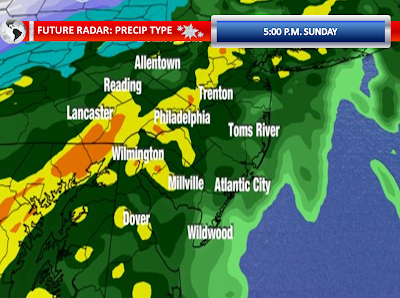
Meanwhile, scattered areas of rain showers will fill in as the night progresses. The models are still indicating excessive rainfall late tonight and early on Friday Morning. The future radar, high resolution models shows this very nicely. You can see a nice convective type feature moves through around 2:00 a.m. Friday.


Heavy Rain Moves In


Round one of the heavy rain is now taking over Southwestern New Jersey and Northwestern New Jersey. The very sharp cutoff line is slowly moving east-northeast and will take more and more areas into the rain as the morning and early afternoon progresses. Flood advisories have already been posted in advance of this line for the majority of New Jersey. A flood watch remains in effect for all 21 New Jersey counties. A coastal flood watch continues for Salem, Camden, Gloucester, and Northwestern Burlington Counties for areas along the Delaware River. Flood warnings remain in effect along the Passaic River basin where the flood waters never receded from the previous heavy rain event on Sunday.

East-southeast winds are so far sustained 15 to 25 MPH with gusts to about 35 MPH. As the low pressure areas strengthen and get closer to our region, the gradient should tighten further. The strongest winds will probably be late this afternoon and early this evening. Gusts should be pretty significant in our eastern counties for a time.

Both the GFS and NAM agree that there will be torrential rain falling in the evening or 12 hours from now.

Wednesday, March 9, 2011

3/9/2011 Extended Forecast: Flood Watch for All of NJ Now/ Strong Winds Expected


UPDATE @ 3:25 p.m.: Coastal Flood Watches have been posted for rather unusual, but significant tidal flooding along the Delaware River from Trenton and points south (let alone the rain flooding that may occur) for Northwestern Burlington, Camden, Gloucester, and Salem Counties...


The east-southeast wind is already cranking across our region today. Winds are sustained 10 to 15 MPH with frequent gusts of 20 to 30 MPH. These winds will only increase as the storm system evolves and moves closer to New Jersey. Vigorous negatively tilted trough and the position of the double-barrel low pressure areas will provide a nice setup for a strong fetch off the Atlantic Ocean and it will also provide a nice setup for strong wind gusts. There is no doubt this will be a windswept rainfall. A low center may exist across the Great Lakes with another forming along the Middle Atlantic. The one across the Middle Atlantic now appears it will move from east into the interior of Central Pennsylvania. This track will really bring in that stream of moisture. Meanwhile, high pressure will be to the north and east of Maine, and that will really work to tighten the gradient. I think the strongest wind gusts will be along our coastlines of Monmouth, Ocean, Southeastern Burlington, and Cape May Counties. Wind gusts past 55 MPH wouldn’t surprise me in these eastern counties during the height of the storm. They will drop off inland, but gusts will still be in excess of 40 MPH. There is the potential for structural damage to the trees and utility poles as the ground is so saturated that these wind gusts would be capable of knocking them down. . I think we will see so much rain that many of the weakened trees even without the wind could fall with the loosened soil. Of course flood waters can also be powerful enough to take down trees. The bottom line is strong easterly to southeasterly winds can be anticipated. Behind the departing system, northwesterly to westerly winds will occur on Friday. With a high pressure area building in, some more windy conditions can be expected, albeit not as intense. The previous Sunday storm, which did not have as strong of an east-southeast setup was able to get wind gusts to 56 MPH in New York City with widespread frequent gusts of around or above 40 MPH in New Jersey. So I do have reason to believe this will be a more impacting strong to high wind event.

Coastal flooding is going to be another concern with a persistent easterly flow. I think the water will pile up fairly well along our coastal communities. Widespread minor tidal flooding looks like a good bet. Some communities should experience moderate coastal flooding with my wind projections.

It appears as though the models want to now show to distinct rounds of heavy rainfall. The one round will be the moisture that streams up from Louisiana and the Florida Panhandle where tornado watches are currently in effect. Then the second round will be the evening and nighttime round which should put many low-lying areas and eventually waterways over their banks. In-between these rounds, there could even be a brief few hour lull (lighter rain?) in the action. Two to three inches of rain will likely fall from Thursday Afternoon into Friday Morning. Some areas will see localized amounts of four to six inches. Historic flooding is quite possible in Northern New Jersey where there is still ongoing flooding around the Passaic River Basin. The water levels will drop some, but perhaps not below flood stage prior to this event. Just imagine the rises in this area this time around as last time around we at least started below flood stage. Elsewhere, even if there is not ongoing flooding, should three inches fall, significant flooding is expected if the rainfall predictions are realized. Some of the flooding could be of moderate to major severity.

Tidal effects will aggravate the flooding along the Delaware River and along the coastline. I remain persistent that anyone living in an area that has flooded in the past few decades should prepare for flooding this go around. Move furniture to higher ground and have an evacuation plan in place. During the heavy rain, flooding in most areas will occur in low spots, around ditches, streets with areas of poor drainage, and at smaller creeks and streams. Then all that water on Friday will head towards the major creeks and major rivers. The rises here will be perhaps slow as it will take time for the runoff to make its way there, although if four inches of rain falls, a much faster rise can be expected, perhaps a flashier flood. The ground is so saturated that this rain cannot be absorbed. Trees are also not sucking in the water since there are no canopies to support. Numerous road closures are expected Thursday Night and Friday Morning.

Some isolated strong to severe thunderstorms cannot be ruled out. There appears to be some marginal instability. Some embedded thunderstorms will be associated with the low as it rides up the cold front. The convection will be mainly low-topped. Strong easterly winds may be enhanced by the convection just like last March when there was a few rumbles of thunder with the monster Nor’easter. With such a well-organized rain shield, detecting microbursts and weak tornadoes are difficult and it may not necessarily happen. It will all be about the parameters in place as the convection approaches from the south. The severe weather threat will be very limited, but not impossible. Any squall-lines that form to our south will have to be watched to see if they move into our region. Lightning could be limited with any convection that does form.

The flood watch now includes all of New Jersey’s 21 Counties. I couldn’t agree with this decision more. My wind forecast is presently more robust than the National Weather Service’s wind forecast. I am well aware. The stronger winds I am expecting is like a domino effect because it is related to tidal flooding in many aspects leading to a more dramatic coastal flood forecast from me. Eventually, in time, I suspect wind advisories and coastal flood statements will be issued for the eastern counties, even if it is issued during the storm. In the March 2010 storm, there were plenty of last minute issuances and upgrades. I have enough confidence in the overall setup to take a step away from cautiousness. If there are already 29 MPH gusts in interior Burlington County, how can I go wrong with the wind forecast during the peak of the storm?

Anyway, I will be updating the forecast again late tonight and all day tomorrow I will have extensive coverage.

Tuesday, March 8, 2011

Flood Watch Issued for Thursday into Friday


The National Weather Service earlier this morning already placed a good portion of New Jersey under a flood watch from Thursday Morning into Friday Morning. Usually a watch would be issued slightly closer to the event. However, the model guidance continues to yield high confidence that another significant…if not excessive…rainfall event will impact the region on Thursday. The heaviest rain may wait until later on Thursday with cresting of waterways occurring approximately twelve to twenty-four hours later.

I am still confident in a widespread two to three inch rainfall, with locally higher amounts between four and six inches. I wouldn’t be surprised that some of sandier soil counties are added to the watch as the event gets closer. These rainfall amounts will result in moderate to major severity flooding. Some of the waterways in Northern New Jersey are still under a flood warning and some are awaiting a crest that will not occur until late tonight or Wednesday Morning at major flood stage. Since I do not believe these rivers will recover in time, historic flooding is a possibility for the Passaic River areas under the current warnings.

Monday, March 7, 2011

Flood Warnings for North and Central NJ


Moderate to major severity flooding has been reported in North Jersey this morning. Minor to moderate severity flooding has been reported in Central New Jersey. Basically, the forecast on this site held true. A widespread two to three inches fell across much of New Jersey with less in Cape May and more in Northwestern New Jersey. I had put on the site a few days ago a map that showed the different rain amounts needed in six hours or less to cause flooding and much of the current area with flooding exceeded those needed amounts. Even portions of the Delaware River north of Trenton are approaching flood stage and some flood warnings have been issued for minor flooding.

Unfortunately, boats could be the method of travel at the end of this week for portions of the Garden State as another super soaker could be on the way. The latest 12z Models just in are indicating another two to three inches of rain possible Thursday Afternoon into Friday Morning. This looks like another potential wind situation as well with strong wind gusts. I’ll post more on this storm later tonight.


Sunday, March 6, 2011

Very Heavy Rain and Thunderstorms On The Way


The threat for heavy rain this evening and overnight continues across New Jersey. While we have had some scattered heavy showers this morning, the main course is waiting to impact us. The radar picture just after noon showed a surface low beginning to develop and intensify along a slow moving cold front moving eastward. Rich gulf moisture and moisture from the Atlantic can be seen injecting itself into the surface low. The low is currently around the Southern Appalachians. The low will move into the Carolina Piedmont and eventually eject northward into our region. As the system gets closer to our region, both the front and the low will begin to develop some heavy, steady rainfall. The heaviest axis of rain will setup in Northwestern New Jersey down through Eastern Pennsylvania. The NAM and GFS models show even heavy rain in Cape May, but I am still expecting lesser amounts in our southeastern counties. The higher resolution models aren’t as robust as the morning GFS and NAM on torrential rain at the shore points.

With New Jersey in the right guardant of this low, I expect it to turn windy for at least a short period of time. Wind gusts of near or in excess of 50 MPH certainly are possible as the front pushes through and the surface low moves to the north and east. With the wet ground, these wind gusts may be able to uproot trees. The heavier rain could be able to transport the stronger winds to the surface. The right quadrant also means that there could be some marginal instability for some thunderstorms. The models indicate low-topped convection with the actual surface low itself, regardless of if you will be on the right side. Any convection will be underneath all of this heavy rain. These situations pose a challenge to detect wet microbursts or a weak tornado, but these are certainly possible with any thunderstorm given the setup.

The high resolution models show cold air catching up with the precipitation on Monday Morning prior to and during the morning commute. It could be cold enough to change the precipitation to sleet and wet snow in our Northwestern Counties. The setup leaves me still with some doubts, but it can happen and one must maintain an eye on the credible models suggesting this possibility.

Saturday, March 5, 2011

3/5/2011 Extended Forecast: Flood Threat, T-Storms


For more on the heavy rain threat, see the previous post.

The latest high resolution modeling is in agreement with the more general modeling that the steadiest and heaviest rain will not be affecting the Garden State until Sunday Afternoon and Sunday Evening. I still also believe that the lowest rain amounts will be recorded around Cape May with the highest amounts in Northwestern New Jersey.

Recent heavy rainfall in February, especially north and west of Philadelphia, and all of the melting snow has caused our waterways to run above normal. Therefore, flash flood guidance is low across a good portion of the Northern and Central New Jersey. According to the updated guidance, one to two inches of rain in six hours or less is all it would take to cause flooding in the Raritan Basin region. For Southern New Jersey, three to four inches of rain would begin to cause flooding. Unfortunately, the latest model guidance has the heaviest rainfall axis where the guidance shows the lower values. This is the reason a flood watch remains posted for Northern and Central New Jersey. Two to three inches of rain with locally higher amounts are possible in Northern and Central New Jersey. One to two inches of rain is expected elsewhere in Southern New Jersey. Cape May could see amounts under an inch. We need to watch to see if any training or terrain effects result in a narrow corridor of 3-6 inches of rain.

For the New Jersey counties within the flood watch, there is a strong potential to see creeks and streams rise and exceed flood stage. The watch area could also have numerous road closures and washed out roadways if amounts exceed two inches. Outside of the watch area, while the road closures may not be as widespread, some street flooding and poor drainage flooding is quite possible. The entire forecast area will likely see hydroplaning conditions by nightfall. Ditches will also fill to capacity.

By evening, everyone should be into steady moderate rain with those pockets of heavier rain. The low developing on the front will be so strong that low-topped convection may develop in the entire region, despite a true lack of instability. In our eastern counties, the lack of rain initially during the day could allow for temperatures to spike up into the sixties and this may add marginal instability in those areas. Don’t be surprised to see some thunderstorms Sunday Evening and Sunday Night. The higher resolution modeling wants bring a line of convection through the area from 4:00 p.m. to 9:00 p.m. The low pressure center will allow for Garden State to be within the right quadrant and any unforeseen instability would be able to trigger potential severe thunderstorms. Sometimes these events could cause a wet microburst or a hard to detect, weak tornado embedded within the heavy rain.

Let’s know get the wind potential. The cold front will cause a strong southerly flow to develop in advance of it. The heavier rain could certainly transport stronger winds to the surface. The winds aloft do not look the most impressive, but there is enough of a kick aloft to be concerned about. With the low crossing our region, the gradient does tighten enough to suspect that a period, perhaps short-lived, of windy conditions could occur. With the saturated ground, the wind potential must be monitored. South winds could be sustained 20 to 25 MPH with gusts of up to 45 MPH. I could even see some areas, especially in the coastal counties; see wind gusts of near or in excess 50 MPH during the frontal and low pressure passage. The wind will be dependent on the exact low pressure center movement and there is low confidence about the wind threat.

Some of the model guidance wants to show this ending as wet snow and sleet Northwestern New Jersey. It will be dependent on whether the cold air catches up with the precipitation behind the cold front. It is not impossible to see this happen, but I have my doubts. I don’t see the best setup for this to occur. The primary impact in these areas will be the flooding and even mudslides in the higher terrain.

The rain will end rapidly on Monday and we will deal with lingering runoff causing flooding. The wind will be stiff with the departing low and incoming high. Tuesday looks seasonable. Wednesday will be mostly cloudy as a warm front passes through and this front perhaps could create some showers. By Thursday, another strong front with low pressure will bring a heavy rain threat. More thunderstorms and windy conditions are possible.

Thursday, March 3, 2011

3/3/2011 Extended Forecast


Another cold tonight is on tap with lows in the upper teens and lower twenties. Some high clouds will begin to become noticeable overnight and during the day on Friday. A warm front moving through on Friday Afternoon and Friday Evening will swing through without much measurable precipitation, if any at all. Warmer air moving in on Friday Night into Saturday Morning may combine with increasing moisture to form some areas of low clouds. Clouds will thin on Saturday and some peaks of sunshine could push to or above 60 degrees. The clouds will increase and thicken again on Saturday Night ahead of a cold front.

The cold front will arrive on Sunday. The timing on the model guidance today is in much less agreement than on the guidance yesterday. The GFS would have rain moving in quicker than the NAM model and this would have an impact on temperatures and we all know this plays a factor in the available instability. The computer models do show some pretty decent forcing for six to twelve hours as the front moves through the region which is indicative of a soaking rain and even a few thunderstorms for that length of time, especially as an area of low pressure moves northward along the front. A quick inch to an inch and one half of rain may fall before the front pushes offshore. Isolated maximum rainfall reports of two to three inches are possible where thunderstorms occur, although there is considerable uncertainty on the convection threat. This rain in such a short time frame could cause street flooding, poor drainage flooding, and cause significant rises (but in most instances the rises will remain below flood stage) on the tributaries, creeks, and streams. I think most areas will be able to handle an inch of rain, despite some higher than normal waterway levels and ditches having more than half of their capacity. The guidance continues to suggest a more significant rain event west of New Jersey. The wind on Sunday may pick up with the frontal passage or any thunderstorms. The wind forecast will be examined more closely on Saturday Evening.

Slow clearing will be underway on Monday, with a sunny day to follow on Tuesday. Wednesday will be impacted with a warm front, followed by a cold front perhaps as late as Thursday. More heavy showers and thunderstorms could be possible…along with gusty winds.

Wednesday, February 23, 2011

2/23/2011 Extended Forecast: 2 Major Storms


A warm front will be entering our region on Thursday Night. A strong area of low pressure will be attached with this warm front as it lifts into our region. A strong moisture connection will become established and this setup will most definitely result in a drenching rain across the region. Two to four inches remains my call for the areas that see all liquid rain. This rainfall will combine with the melting snow in the Northern and Southern parts of New Jersey to increase the potential for flooding of creeks and streams. Should it rain heavily in Northeast Pennsylvania or in Southern-Central New York, that water would runoff down the Delaware River and combine with the runoff from our counties. There is some uncertainty as to whether it will be rain, freezing rain, or a mixture of rain and wet snow in Northwestern New Jersey and Northeastern Pennsylvania. The best chance of any frozen mix would be Thursday Night in Northwest New Jersey. I would encourage those who have been impacting by flooding in the past to prepare for possible road closures and rising water.

The initial surge of warm air will be accompanied by gusty winds with stronger winds aloft. Will these winds reach the surface at night? A few weeks ago the winds did pretty well at night with the surge. The warm front will have difficulty moving into Northern and Central New Jersey and whether it lifts completely through New Jersey remains a challenging situation to predict. The result is questions about instability, shear, temperatures, and dew points. At this stage of the game, it is expected that most of Southern New Jersey could enter the warm sector Friday Morning into Friday Afternoon. Temperatures may be holding in the forties north of Interstate 195 while areas south of this line are in the fifties, if not the lower and mid-sixties. There could even be some partial clearing in portions of Southern New Jersey. If portions of New Jersey get into the warm sector during the daylight hours, strong southwest winds approaching wind advisory criteria are certainly possible. By this time the ground should be soaked, unlike prior events, and this could mean some issues. Then, some of the models show enough shear, instability, and moisture to trigger a line of squall line or at least isolated cellular features in this warm sector ahead of a strong cold front and these features would pose a risk for damaging wind gusts. The cold front will be moving through the entire region and as it approaches and behind it, into Saturday, some strong to high winds could once again begin our weekend. If this is the case, unlike last weekend, our ground will be very saturated by this period in time which could result in an increased chance of downed trees.

I also continue to wonder whether the NAM model has any credibility with some snow behind the cold front as colder air comes rushing in. 20 degree temperature drops or more would definitely be possible in just a few hours. I think the NAM could be overdoing the cold rush that would catch up to measurable precipitation in time. The GFS had this possibility, but the latest model run shows the colder air too late for much more than a few snow showers. The low deepens rapidly off the Maine coastline, which would drive in the colder air. The events this season have done pretty well for backend snow, which usually in most seasons’ ends up being a fluke on the models.

A weak clipper system will pass to our north on Sunday. This could deliver a period of snow showers or light snow, particularly in Northern and Central New Jersey.

Another strong warm front, low pressure center, and cold front approach our area for the early week period. More heavy rain, strong winds, strong to severe thunderstorms, and flooding is possible with this system. This one could have a better chance for a squall-line of thunderstorms if the 00z GFS is correct.

Friday and Monday, there is very low confidence on the temperatures in the graphics. There is going to be big gradients and sharp differences across the state. There is a very high bust potential here.