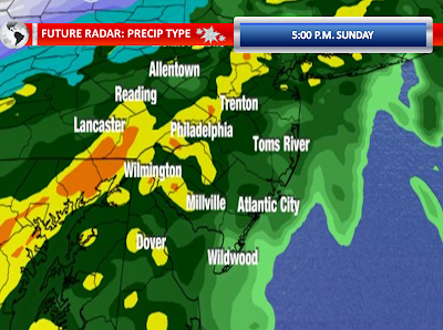


The threat for heavy rain this evening and overnight continues across New Jersey. While we have had some scattered heavy showers this morning, the main course is waiting to impact us. The radar picture just after noon showed a surface low beginning to develop and intensify along a slow moving cold front moving eastward. Rich gulf moisture and moisture from the Atlantic can be seen injecting itself into the surface low. The low is currently around the Southern Appalachians. The low will move into the Carolina Piedmont and eventually eject northward into our region. As the system gets closer to our region, both the front and the low will begin to develop some heavy, steady rainfall. The heaviest axis of rain will setup in Northwestern New Jersey down through Eastern Pennsylvania. The NAM and GFS models show even heavy rain in Cape May, but I am still expecting lesser amounts in our southeastern counties. The higher resolution models aren’t as robust as the morning GFS and NAM on torrential rain at the shore points.
With New Jersey in the right guardant of this low, I expect it to turn windy for at least a short period of time. Wind gusts of near or in excess of 50 MPH certainly are possible as the front pushes through and the surface low moves to the north and east. With the wet ground, these wind gusts may be able to uproot trees. The heavier rain could be able to transport the stronger winds to the surface. The right quadrant also means that there could be some marginal instability for some thunderstorms. The models indicate low-topped convection with the actual surface low itself, regardless of if you will be on the right side. Any convection will be underneath all of this heavy rain. These situations pose a challenge to detect wet microbursts or a weak tornado, but these are certainly possible with any thunderstorm given the setup.
The high resolution models show cold air catching up with the precipitation on Monday Morning prior to and during the morning commute. It could be cold enough to change the precipitation to sleet and wet snow in our Northwestern Counties. The setup leaves me still with some doubts, but it can happen and one must maintain an eye on the credible models suggesting this possibility.

No comments:
Post a Comment