
This is not a tropical storm by any stretch of the imagination, but the winds will be as powerful tonight in gust form. Winds will be sustained between 20 and 35 MPH with gusts to 55 MPH. The cold front is now moving through Pennsylvania. As this front slowly progresses through, I strongly believe we could see some isolated wind gusts up to 65 MPH into tonight for an hour or two after the frontal passage. Currently, we have a wind advisory. Whether we see a high wind warning issued or not, I see the potential is there for at least isolated warning criteria wind gusts. Some whole trees and many branches will likely come down resulting in downed utility wires. We already have a few thousand without power as of mid-afternoon and these numbers will probably increase for a time as the wind is expected to get stronger this evening for a time. Two rough winters of snow and ice has weakened a lot of these branches and the wind doesn’t even need to reach 40 MPH to cause some issues.
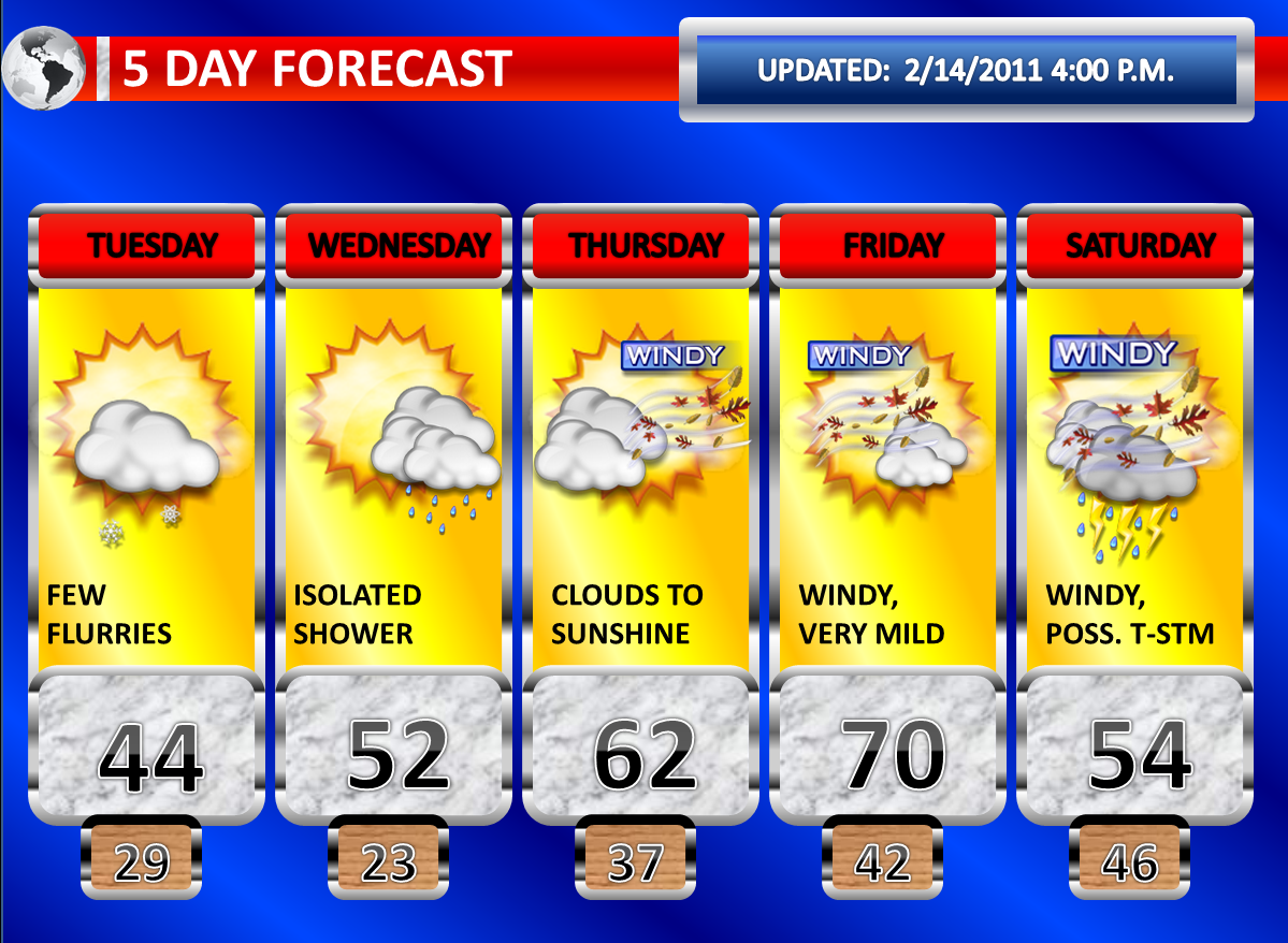
Colder air advection will allow the column to cool to the surface as the night progresses. The strong flow from the northwest will allow for some snow flurries to develop into Tuesday. I continue to maintain a mention of snow flurries in the extended forecast graphic. Tuesday will be blustery and colder, but this cold shot will be brief. Tuesday Night will be chilly with light winds and clear skies.
On Wednesday, temperatures will moderate quite a bit. A warm front will bring an increase in clouds and a chance for some rain showers. The chance for isolated rain showers has also been maintained in my forecast graphic.
Thursday through Early Saturday will be quite mild. Temperatures reached 60 degrees in most areas south of Interstate 195 today. With an even stronger looking warm push, I see no reason why sixties would not be possible again during this late week period. Even some of our northern areas may begin to see some sixties. With this being said, I do think it is possible that a good portion of Southern New Jersey, especially Friday, flirts with or reaches 70 degrees. Localized factors such as leftover snow cover in Northern and Central New Jersey make this difficult to put a number on a graphic as there will likely be a sharper than usual contrast between Northwest New Jersey and Southeast New Jersey. With this being a Central and Southern NJ forecast site, I will go with 70 degrees for Friday. The southwest winds will be quite blustery Thursday and Friday with the wind mixing down as the temperatures rise. Late in the week, some drier ground conditions in Southern New Jersey could increase the risk for fire danger. A cold front should swing through on Saturday Morning which could produce rain showers and thunderstorms. Some of the thunderstorms could be gusty. An earlier frontal passage gives reason to believe Saturday will be colder. Strong winds are possible behind the front.
Don’t look now. But there could be a wintry mess coming for early next week.
No comments:
Post a Comment